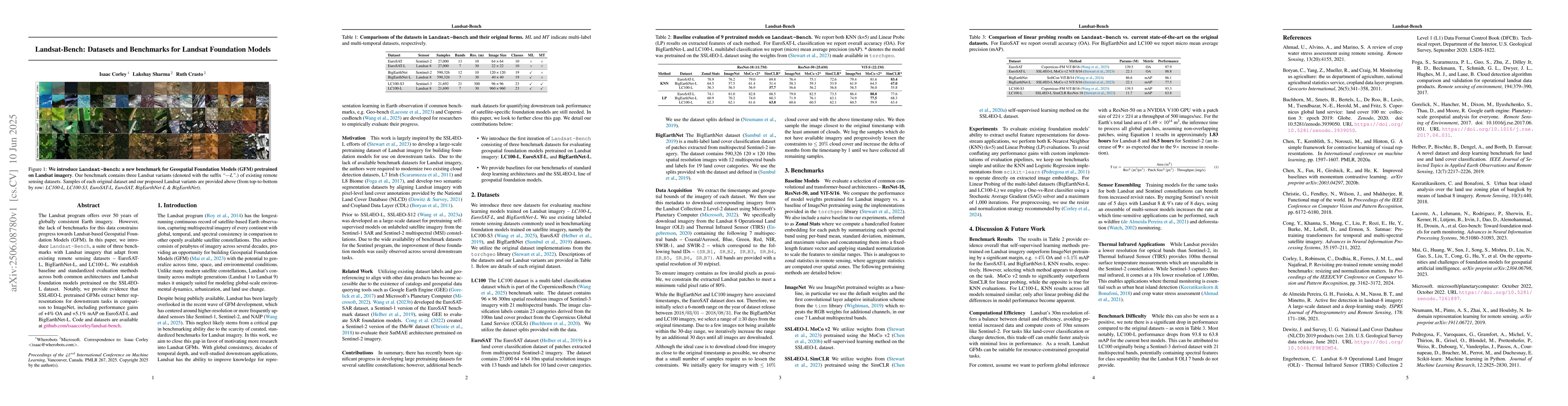
Towards a Unified Copernicus Foundation Model for Earth Vision
|
Yi Wang, Zhitong Xiong, Chenying Liu, Adam J. Stewart, Thomas Dujardin, N. Bountos, Angelos Zavras, Franziska Gerken, Ioannis Papoutsis, Laura Leal-Taix'e, Xiao Xiang Zhu
|
2025
|
View Paper
|
Multilabel-Guided Soft Contrastive Learning for Efficient Earth Observation Pretraining
|
Yi Wang, C. Albrecht, Xiao Xiang Zhu
|
2024
|
View Paper
|
Feature Guided Masked Autoencoder for Self-Supervised Learning in Remote Sensing
|
Yi Wang, Hugo Hern'andez Hern'andez, C. Albrecht, Xiao Xiang Zhu
|
2023
|
View Paper
|
SSL4EO-S12: A large-scale multimodal, multitemporal dataset for self-supervised learning in Earth observation [Software and Data Sets]
|
Yi Wang, Nassim Ait Ali Braham, Zhitong Xiong, Chenying Liu, C. Albrecht, Xiaoxiang Zhu
|
2023
|
View Paper
|
SSL4EO-L: Datasets and Foundation Models for Landsat Imagery
|
A. Stewart, Nils Lehmann, I. Corley, Yi Wang, Yi Chang, Nassim Ait Ali Braham, Shradha Sehgal, Caleb Robinson, Arindam Banerjee
|
2023
|
View Paper
|
GEO-Bench: Toward Foundation Models for Earth Monitoring
|
Alexandre Lacoste, Nils Lehmann, Pau Rodríguez López, Evan D. Sherwin, H. Kerner, Bjorn Lutjens, J. Irvin, David Dao, H. Alemohammad, Alexandre Drouin, Mehmet Gunturkun, Gabriel Huang, David Vázquez, Dava Newman, Y. Bengio, Stefano Ermon, Xiao Xiang Zhu
|
2023
|
View Paper
|
Revisiting pre-trained remote sensing model benchmarks: resizing and normalization matters
|
I. Corley, Caleb Robinson, R. Dodhia, J. Ferres, Peyman Najafirad
|
2023
|
View Paper
|
On the Opportunities and Challenges of Foundation Models for Geospatial Artificial Intelligence
|
Gengchen Mai, Weiming Huang, Jin Sun, Suhang Song, Deepak Mishra, Ninghao Liu, Song Gao, Tianming Liu, G. Cong, Yingjie Hu, Chris Cundy, Ziyuan Li, Rui Zhu, Ni Lao
|
2023
|
View Paper
|
SatMAE: Pre-training Transformers for Temporal and Multi-Spectral Satellite Imagery
|
Yezhen Cong, Samarth Khanna, Chenlin Meng, Patrick Liu, Erik Rozi, Yutong He, M. Burke, D. Lobell, Stefano Ermon
|
2022
|
View Paper
|
A Review of Crop Water Stress Assessment Using Remote Sensing
|
Uzair Ahmad, A. Alvino, S. Marino
|
2021
|
View Paper
|
Deep Learning for Geospatial Data
|
J. D. Wegner
|
2021
|
View Paper
|
Active Fire Detection in Landsat-8 Imagery: a Large-Scale Dataset and a Deep-Learning Study
|
G. Pereira, A. M. Fusioka, B. Nassu, R. Minetto
|
2021
|
View Paper
|
Copernicus Global Land Service: Land Cover 100m: collection 3: epoch 2019: Globe
|
M. Buchhorn, B. Smets, L. Bertels, D. Roo, M. Lesiv, N. Tsendbazar, M. Herold, S. Fritz
|
2020
|
View Paper
|
Improved Baselines with Momentum Contrastive Learning
|
Xinlei Chen, Haoqi Fan, Ross B. Girshick, Kaiming He
|
2020
|
View Paper
|
A Simple Framework for Contrastive Learning of Visual Representations
|
Ting Chen, Simon Kornblith, Mohammad Norouzi, Geoffrey E. Hinton
|
2020
|
View Paper
|
In-domain representation learning for remote sensing
|
Maxim Neumann, André Susano Pinto, Xiaohua Zhai, N. Houlsby
|
2019
|
View Paper
|
Microsoft
|
|
2019
|
|
Bigearthnet: A Large-Scale Benchmark Archive for Remote Sensing Image Understanding
|
Gencer Sumbul, Marcela Charfuelan, B. Demir, V. Markl
|
2019
|
View Paper
|
Urban Heat Island Analysis over the Land Use Zoning Plan of Bangkok by Means of Landsat 8 Imagery
|
Chaiyapon Keeratikasikorn, S. Bonafoni
|
2018
|
View Paper
|
Google Earth Engine: Planetary-scale geospatial analysis for everyone
|
N. Gorelick, Matt Hancher, M. Dixon, S. Ilyushchenko, D. Thau, R. Moore
|
2017
|
View Paper
|
Functional Map of the World
|
Gordon A. Christie, Neil Fendley, James Wilson, R. Mukherjee
|
2017
|
View Paper
|
EuroSAT: A Novel Dataset and Deep Learning Benchmark for Land Use and Land Cover Classification
|
P. Helber, B. Bischke, A. Dengel, Damian Borth
|
2017
|
View Paper
|
Cloud detection algorithm comparison and validation for operational Landsat data products
|
Steve Foga, P. Scaramuzza, Song Guo, Zhe Zhu, Ronald D. Dilley, Tim Beckmann, G. Schmidt, J. Dwyer, M. Hughes, Brady Laue
|
2017
|
View Paper
|
Global Forest Watch
|
Matthew C. Hansen
|
2016
|
View Paper
|
Landsat-8: Science and Product Vision for Terrestrial Global Change Research
|
D. Roy, M. Wulder, T. Loveland, C. Woodcock, R. Allen, Martha C. Anderson, D. Helder, J. Irons, Daniel M. Johnson, R. Kennedy, T. Scambos, C. Schaaf, J. Schott, Y. Sheng, E. Vermote, A. Belward, R. Bindschadler, W. Cohen, F. Gao, J. Hipple, P. Hostert, J. Huntington, C. Justice, A. Kilic, V. Kovalskyy, Z. Lee, L. Lymburner, J. Masek, J. McCorkel, Y. Shuai, R. Trezza, J. Vogelmann, R. Wynne, Zhe Zhu
|
2014
|
View Paper
|
Development of the Landsat Data Continuity Mission Cloud-Cover Assessment Algorithms
|
P. Scaramuzza, M. Bouchard, J. Dwyer
|
2012
|
View Paper
|
Monitoring US agriculture: the US Department of Agriculture, National Agricultural Statistics Service, Cropland Data Layer Program
|
C. Boryan, Zhengwei Yang, R. Mueller, M. Craig
|
2011
|
View Paper
|
Scikit-learn: Machine Learning in Python
|
Fabian Pedregosa, G. Varoquaux, Alexandre Gramfort, V. Michel, B. Thirion, O. Grisel, Mathieu Blondel, Gilles Louppe, P. Prettenhofer, Ron Weiss, Ron J. Weiss, J. Vanderplas, Alexandre Passos, D. Cournapeau, M. Brucher, M. Perrot, E. Duchesnay
|
2011
|
View Paper
|
ImageNet We use ImageNet pretrained weights as a base-line, in particular we use the default weights and the first convolutional layer adaptive initialization scheme from the timm library
|
|
2019
|
|
Pytorch image models
|
|
2019
|
|
National Land Cover Database (NLCD) 2019 products (ver. 2.0)
|
|
|
|
Landsat 8–9
|
|
|
|
SSL4EO-L SimCLR We utilize weights from (Stewart et al., 2023) pretrained using the SimCLR
|
|
|
|
Comments (0)