Landsat30-AU: A Vision-Language Dataset for Australian Landsat Imagery
Publication
Metrics
Paper Preview
Abstract
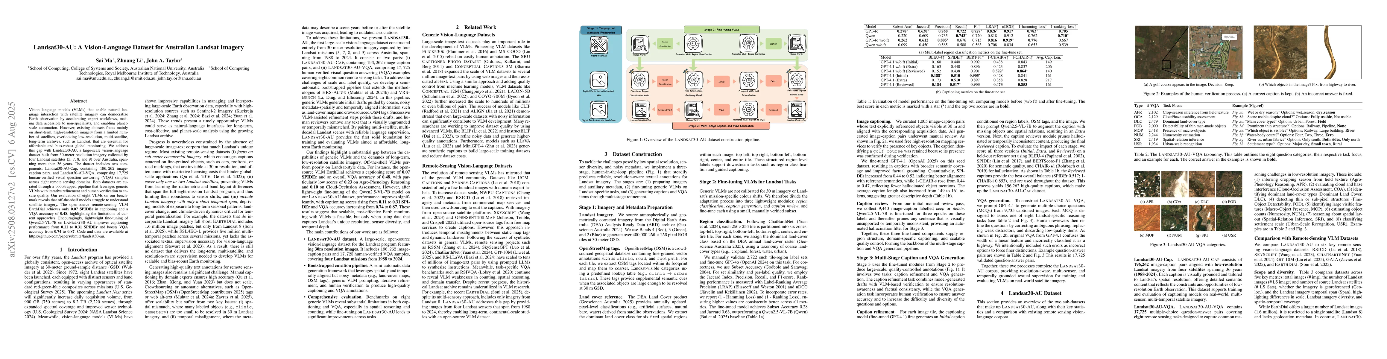
Vision language models (VLMs) that enable natural language interaction with satellite imagery can democratize Earth observation by accelerating expert workflows, making data accessible to non-specialists, and enabling planet-scale automation. However, existing datasets focus mainly on short-term, high-resolution imagery from a limited number of satellites, overlooking low-resolution, multi-satellite, long-term archives, such as Landsat, that are essential for affordable and bias-robust global monitoring. We address this gap with Landsat30-AU, a large-scale vision-language dataset built from 30-meter resolution imagery collected by four Landsat satellites (5, 7, 8, and 9) over Australia, spanning more than 36 years. The dataset includes two components: Landsat30-AU-Cap, containing $196,262$ image-caption pairs, and Landsat30-AU-VQA, comprising 17,725 human-verified visual question answering (VQA) samples across eight remote sensing domains. Both datasets are curated through a bootstrapped pipeline that leverages generic VLMs with iterative refinement and human verification to ensure quality. Our evaluation of eight VLMs on our benchmark reveals that off-the-shelf models struggle to understand satellite imagery. The open-source remote-sensing VLM EarthDial achieves only 0.07 SPIDEr in captioning and a VQA accuracy of 0.48, highlighting the limitations of current approaches. Encouragingly, lightweight fine-tuning of Qwen2.5-VL-7B on Landsat30-AU improves captioning performance from 0.11 to 0.31 SPIDEr and boosts VQA accuracy from 0.74 to 0.87. Code and data are available at https://github.com/papersubmit1/landsat30-au.
AI Key Findings
Get AI-generated insights about this paper's methodology, results, significance, and more — seven facets brought into focus.
Discussion 0