We introduce LandslideBench a multimodal fine-grained dataset, train LandslideVLM via LoRA on LandslideBench to enhance geological semantics, and deploy LandslideAgent with a dual-rule controller that enforces structured report metadata constraints and cross-validation identification constraints to regulate automated tool invocation for autonomous landslide identification and analysis.
LandslideAgent with Multimodal LandslideBench: A Domain-Rule-Augmented Agent for Autonomous Landslide Identification and Analysis
Publication
Metrics
Quick Answers
What methodology did the authors use?
We introduce LandslideBench a multimodal fine-grained dataset, train LandslideVLM via LoRA on LandslideBench to enhance geological semantics, and deploy LandslideAgent with a dual-rule controller that enforces structured report metadata constraints and cross-validation identification constraints to regulate automated tool invocation for autonomous landslide identification and analysis. More in Methodology →
What are the key results?
LandslideBench provides effective baselines across five mainstream models for fine-grained classification and semantic segmentation. — LandslideVLM achieves accuracy improvements of 10.96% on landslide discrimination, 32.87% on fine-grained classification, and 15.91% on semantic description quality. More in Key Results →
Why is this work significant?
The framework integrates domain-specific multimodal data, a landslide-oriented vision-language model, and a rule-based agent to overcome pure-vision model limitations and domain hallucinations, enabling high-level geoscientific reasoning alongside precise visual recognition for hazard analysis. More in Significance →
What are the main limitations?
Performance gains are reported on benchmarked datasets and may not fully capture real-world variability across diverse terrains and sensor modalities. — The reliance on domain-specific rules may limit adaptability to novel, unseen geologic contexts without additional rule engineering. More in Limitations →
Abstract
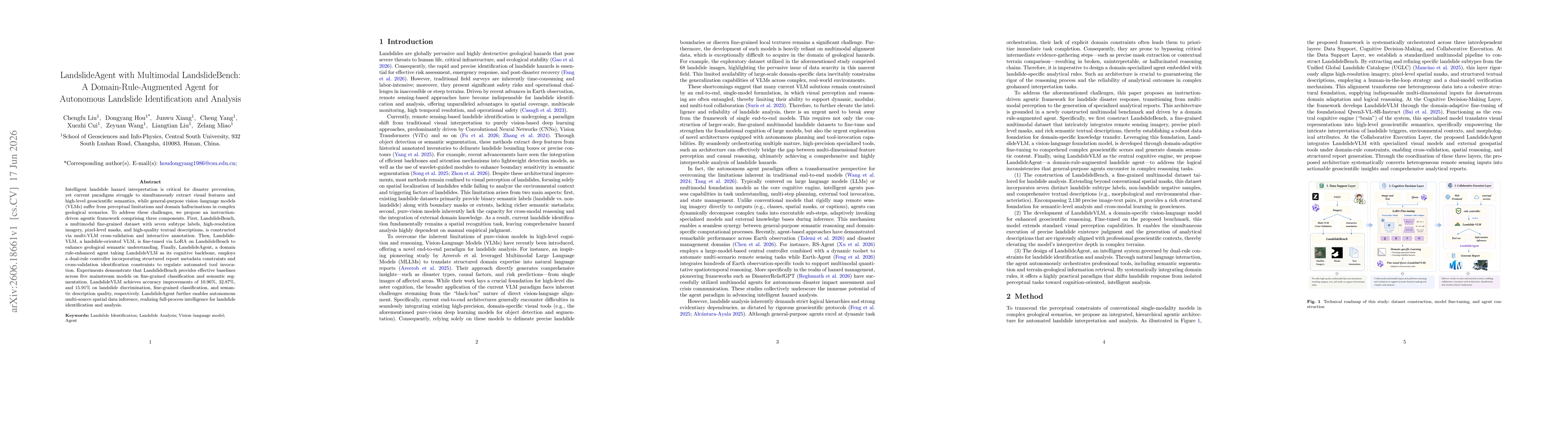
Intelligent landslide hazard interpretation is critical for disaster prevention, yet current paradigms struggle to simultaneously extract visual features and high-level geoscientific semantics, while general-purpose vision-language models (VLMs) suffer from perceptual limitations and domain hallucinations in complex geological scenarios. To address these challenges, we propose an instruction-driven agentic framework comprising three components. First, LandslideBench, a multimodal fine-grained dataset with seven subtype labels, high-resolution imagery, pixel-level masks, and high-quality textual descriptions, is constructed via multi-VLM cross-validation and interactive annotation. Then, LandslideVLM, a landslide-oriented VLM, is fine-tuned via LoRA on LandslideBench to enhance geological semantic understanding. Finally, LandslideAgent, a domain rule-enhanced agent taking LandslideVLM as its cognitive backbone, employs a dual-rule controller incorporating structured report metadata constraints and cross-validation identification constraints to regulate automated tool invocation. Experiments demonstrate that LandslideBench provides effective baselines across five mainstream models on fine-grained classification and semantic segmentation. LandslideVLM achieves accuracy improvements of 10.96%, 32.87%, and 15.91% on landslide discrimination, fine-grained classification, and semantic description quality, respectively. LandslideAgent further enables autonomous multi-source spatial data inference, realizing full-process intelligence for landslide identification and analysis.
Key Findings, in focus
Seven facets of this paper, analysed and brought into focus by AI.
The framework integrates domain-specific multimodal data, a landslide-oriented vision-language model, and a rule-based agent to overcome pure-vision model limitations and domain hallucinations, enabling high-level geoscientific reasoning alongside precise visual recognition for hazard analysis.
- LandslideBench provides effective baselines across five mainstream models for fine-grained classification and semantic segmentation.
- LandslideVLM achieves accuracy improvements of 10.96% on landslide discrimination, 32.87% on fine-grained classification, and 15.91% on semantic description quality.
- LandslideAgent enables autonomous multi-source spatial data inference, achieving full-process intelligence for landslide identification and analysis.
The framework integrates domain-specific multimodal data, a landslide-oriented vision-language model, and a rule-based agent to overcome pure-vision model limitations and domain hallucinations, enabling high-level geoscientific reasoning alongside precise visual recognition for hazard analysis.
Proposes a domain-rule-augmented agentic framework with LandslideBench, LandslideVLM fine-tuned via LoRA, and LandslideAgent featuring a dual-rule controller to regulate tool invocation and cross-validation-based reasoning for landslide identification and analysis.
First to combine a domain-specific multimodal LandslideBench with a landslide-oriented VLM and a rule-guided agent to achieve autonomous, end-to-end landslide identification and analysis, addressing both high-level geological semantics and precise visual comprehension.
- Performance gains are reported on benchmarked datasets and may not fully capture real-world variability across diverse terrains and sensor modalities.
- The reliance on domain-specific rules may limit adaptability to novel, unseen geologic contexts without additional rule engineering.
- Extend LandslideBench with additional environmental factors and temporal sequences to improve longitudinal analysis.
- Explore automatic rule-learning or learning-to-rule mechanisms to reduce manual rule curation in LandslideAgent.
- Evaluate robustness against sensor noise and occlusions in real-world deployment scenarios.
Discussion 0