Quick Answers
What methodology did the authors use?
The research introduces LC-SLab, a deep learning framework that combines object-based classification with graph neural networks and postprocessing techniques from semantic segmentation models. It leverages pre-trained networks to enhance performance on small datasets and evaluates the framework using Sentinel-2 satellite imagery with sparse LUCAS labels. More in Methodology →
What are the key results?
Object-based methods in LC-SLab match or exceed pixel-wise models in accuracy while producing more coherent land cover maps. — Input-level aggregation via graph neural networks is more robust on smaller datasets, whereas output-level aggregation performs best with larger datasets. More in Key Results →
Why is this work significant?
This research addresses the challenge of generating accurate large-scale land cover maps with sparse in-situ labels, offering a scalable solution for Earth science applications and improving the coherence of predictions. More in Significance →
What are the main limitations?
The framework's effectiveness may depend on the quality and distribution of sparse in-situ labels. — The study focuses on medium-resolution imagery, which may limit applicability to higher-resolution datasets. More in Limitations →
Abstract
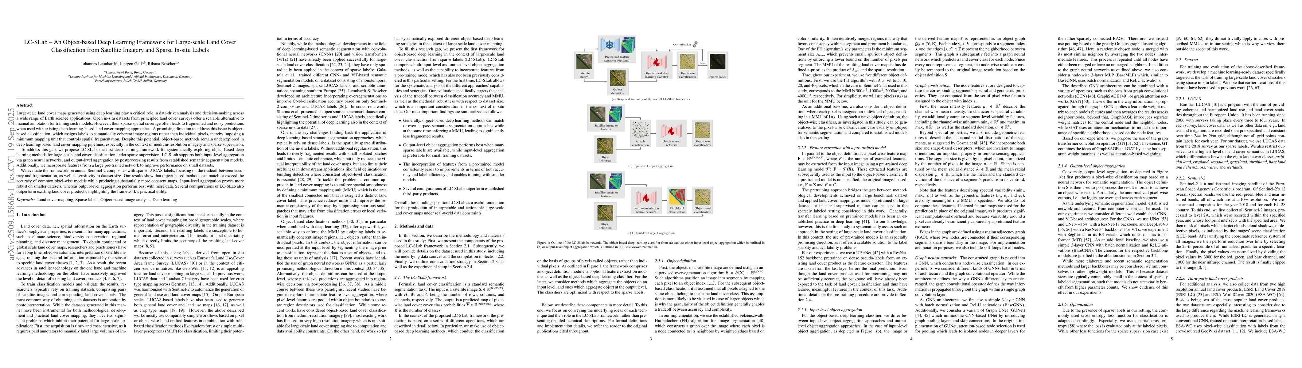
Large-scale land cover maps generated using deep learning play a critical role across a wide range of Earth science applications. Open in-situ datasets from principled land cover surveys offer a scalable alternative to manual annotation for training such models. However, their sparse spatial coverage often leads to fragmented and noisy predictions when used with existing deep learning-based land cover mapping approaches. A promising direction to address this issue is object-based classification, which assigns labels to semantically coherent image regions rather than individual pixels, thereby imposing a minimum mapping unit. Despite this potential, object-based methods remain underexplored in deep learning-based land cover mapping pipelines, especially in the context of medium-resolution imagery and sparse supervision. To address this gap, we propose LC-SLab, the first deep learning framework for systematically exploring object-based deep learning methods for large-scale land cover classification under sparse supervision. LC-SLab supports both input-level aggregation via graph neural networks, and output-level aggregation by postprocessing results from established semantic segmentation models. Additionally, we incorporate features from a large pre-trained network to improve performance on small datasets. We evaluate the framework on annual Sentinel-2 composites with sparse LUCAS labels, focusing on the tradeoff between accuracy and fragmentation, as well as sensitivity to dataset size. Our results show that object-based methods can match or exceed the accuracy of common pixel-wise models while producing substantially more coherent maps. Input-level aggregation proves more robust on smaller datasets, whereas output-level aggregation performs best with more data. Several configurations of LC-SLab also outperform existing land cover products, highlighting the framework's practical utility.
AI Key Findings
Generated Sep 30, 2025
Methodology — What approach did the authors take?
The research introduces LC-SLab, a deep learning framework that combines object-based classification with graph neural networks and postprocessing techniques from semantic segmentation models. It leverages pre-trained networks to enhance performance on small datasets and evaluates the framework using Sentinel-2 satellite imagery with sparse LUCAS labels.
Key Results — What are the main findings?
- Object-based methods in LC-SLab match or exceed pixel-wise models in accuracy while producing more coherent land cover maps.
- Input-level aggregation via graph neural networks is more robust on smaller datasets, whereas output-level aggregation performs best with larger datasets.
- Several LC-SLab configurations outperform existing land cover products, demonstrating practical utility.
Significance — Why does this research matter?
This research addresses the challenge of generating accurate large-scale land cover maps with sparse in-situ labels, offering a scalable solution for Earth science applications and improving the coherence of predictions.
Technical Contribution — What is the technical contribution?
LC-SLab introduces a systematic approach to object-based deep learning for land cover classification, combining input-level and output-level aggregation techniques with pre-trained features for improved performance on small datasets.
Novelty — What is new about this work?
LC-SLab is the first framework to systematically explore object-based deep learning methods for large-scale land cover classification under sparse supervision, integrating graph neural networks and postprocessing techniques from semantic segmentation models.
Limitations — What are the limitations of this study?
- The framework's effectiveness may depend on the quality and distribution of sparse in-situ labels.
- The study focuses on medium-resolution imagery, which may limit applicability to higher-resolution datasets.
Future Work — What did the authors propose for future work?
- Exploring the integration of additional data sources or multi-sensor fusion for improved accuracy.
- Investigating the framework's performance on higher-resolution satellite imagery.
- Developing automated methods for selecting optimal aggregation strategies based on dataset size.
How to Cite This Paper
@article{leonhardt2025lc,
title = {LC-SLab -- An Object-based Deep Learning Framework for Large-scale Land
Cover Classification from Satellite Imagery and Sparse In-situ Labels},
author = {Leonhardt, Johannes and Gall, Juergen and Roscher, Ribana},
year = {2025},
eprint = {2509.15868},
archivePrefix = {arXiv},
primaryClass = {cs.CV},
}
Leonhardt, J., Gall, J., & Roscher, R. (2025). LC-SLab -- An Object-based Deep Learning Framework for Large-scale Land
Cover Classification from Satellite Imagery and Sparse In-situ Labels. arXiv. https://arxiv.org/abs/2509.15868
Leonhardt, Johannes, et al. "LC-SLab -- An Object-based Deep Learning Framework for Large-scale Land
Cover Classification from Satellite Imagery and Sparse In-situ Labels." arXiv, 2025, arxiv.org/abs/2509.15868.
PDF Preview
Similar Papers
Found 4 papersSatellite-Net: Automatic Extraction of Land Cover Indicators from Satellite Imagery by Deep Learning
Harnessing Deep Learning and Satellite Imagery for Post-Buyout Land Cover Mapping
Hakan T. Otal, Elyse Zavar, Sherri B. Binder et al.
Representative-Discriminative Learning for Open-set Land Cover Classification of Satellite Imagery
Craig Stutts, Ying Qu, Razieh Kaviani Baghbaderani et al.
Comments (0)