Quick Summary:

This paper proposes a self-supervised learning framework using spatiotemporal contrast to learn street view representations for urban environments, outperforming traditional methods in tasks like visual place recognition and socioeconomic estimation. The approach leverages temporal and spatial attributes to capture dynamic urban features and neighborhood ambiance.

Summary

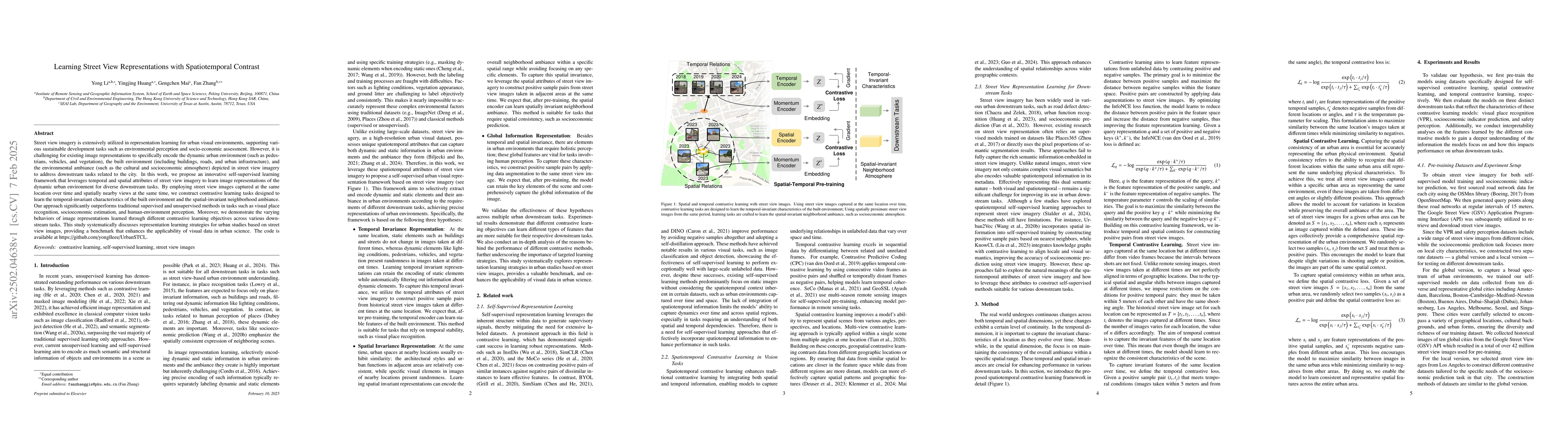
Street view imagery is extensively utilized in representation learning for urban visual environments, supporting various sustainable development tasks such as environmental perception and socio-economic assessment. However, it is challenging for existing image representations to specifically encode the dynamic urban environment (such as pedestrians, vehicles, and vegetation), the built environment (including buildings, roads, and urban infrastructure), and the environmental ambiance (such as the cultural and socioeconomic atmosphere) depicted in street view imagery to address downstream tasks related to the city. In this work, we propose an innovative self-supervised learning framework that leverages temporal and spatial attributes of street view imagery to learn image representations of the dynamic urban environment for diverse downstream tasks. By employing street view images captured at the same location over time and spatially nearby views at the same time, we construct contrastive learning tasks designed to learn the temporal-invariant characteristics of the built environment and the spatial-invariant neighborhood ambiance. Our approach significantly outperforms traditional supervised and unsupervised methods in tasks such as visual place recognition, socioeconomic estimation, and human-environment perception. Moreover, we demonstrate the varying behaviors of image representations learned through different contrastive learning objectives across various downstream tasks. This study systematically discusses representation learning strategies for urban studies based on street view images, providing a benchmark that enhances the applicability of visual data in urban science. The code is available at https://github.com/yonglleee/UrbanSTCL.

AI Key Findings

Generated Jun 11, 2025

Methodology

The research proposes a self-supervised learning framework for urban visual representation learning using street view images, leveraging spatiotemporal attributes to encode dynamic and static urban elements for various downstream tasks.

Key Results

  • The proposed framework significantly outperforms traditional supervised and unsupervised methods in tasks like visual place recognition, socioeconomic estimation, and human-environment perception.
  • Temporal contrastive learning excels in visual place recognition tasks, demonstrating robustness across seasons.
  • Spatial contrastive learning shows superior performance in socioeconomic indicator prediction, capturing the overall ambiance of urban areas.
  • GSV-Self model outperforms others in safety perception tasks, effectively distinguishing between safe and unsafe environments.
  • Different contrastive learning methods excel in different tasks: temporal for VPR, spatial for socioeconomic prediction, and self for safety perception.

Significance

This study systematically explores representation learning strategies for urban studies using street view images, providing a valuable benchmark for the application of visual data in urban science and enhancing their practical applicability.

Technical Contribution

The paper introduces a novel self-supervised learning framework that utilizes spatiotemporal contrastive learning to extract task-specific features from street view images, significantly improving performance in urban understanding tasks.

Novelty

The work distinguishes itself by focusing on the spatiotemporal attributes of street view imagery for contrastive learning, enabling the extraction of both temporal-invariant built environment characteristics and spatial-invariant neighborhood ambiance.

Limitations

  • The study does not extensively cover the generalization of the models to other urban contexts beyond the studied cities.
  • The performance evaluation is primarily based on specific datasets, which might limit the applicability to diverse urban environments.

Future Work

  • Investigate the generalizability of the proposed methods across various urban contexts and climates.
  • Explore the integration of additional data sources (e.g., sensor data, satellite imagery) to enhance the robustness and comprehensiveness of urban representations.

Paper Details

PDF Preview

Download PDF

Key Terms

No key terms available for this paper.

Citation Network

Current paper (gray), citations (green), references (blue)

Current Paper
Citations
References
Click to view

Similar Papers

Found 4 papers

Bird's-Eye View to Street-View: A Survey

Muhammad Usman, Saeed Anwar, Abdul Bais et al.

2024-05-16

Animating Street View

Ira Kemelmacher-Shlizerman, Mengyi Shan, Brian Curless et al.

2023-10-13

No citations found for this paper.

Comments (0)

This website uses cookies to ensure you get the best experience. Learn more