Quick Answers
What methodology did the authors use?
The research employs a combination of visual geometry methods (MASt3R, VGGT) and control algorithms (MPPI) to process real-world trajectories and evaluate navigation performance. It involves reconstructing trajectories, analyzing pose predictions, and implementing controllers for autonomous navigation. More in Methodology →
What are the key results?
MASt3R and VGGT produce reconstructions with pose errors and inconsistencies, making direct navigation challenging. — LoTIS provides stable image-space outputs suitable for control, outperforming one-to-many matching approaches in navigation tasks. More in Key Results →
Why is this work significant?
This research highlights the challenges of applying learned visual geometry methods to real-time navigation and demonstrates the effectiveness of specialized control systems for autonomous trajectory following. More in Significance →
What are the main limitations?
MASt3R and VGGT require significant computational resources and time for trajectory reconstruction. — The study focuses on specific trajectory scenarios, limiting generalizability to other environments. More in Limitations →
Abstract
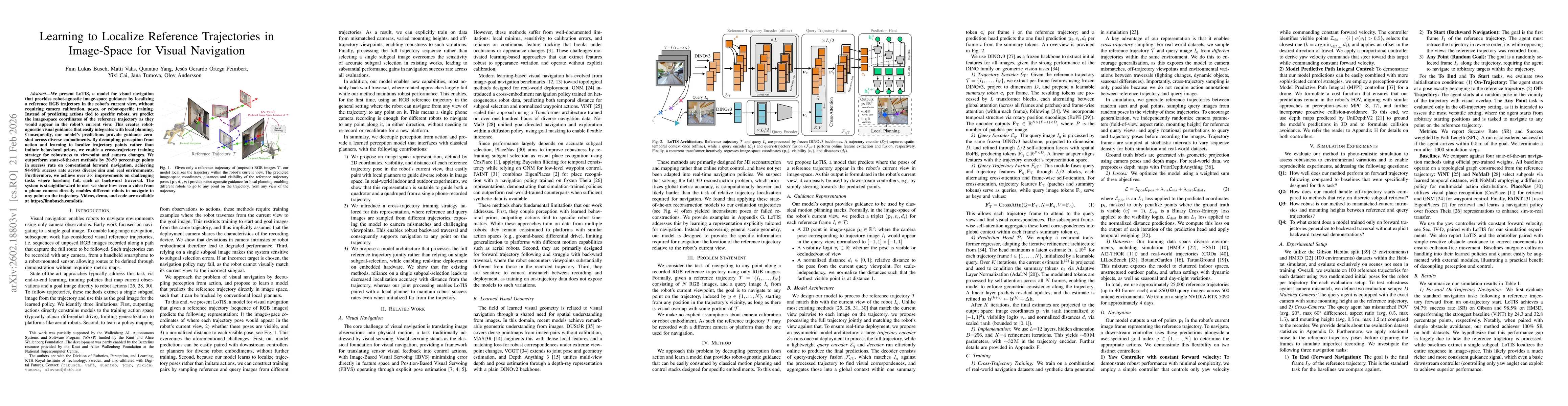
We present LoTIS, a model for visual navigation that provides robot-agnostic image-space guidance by localizing a reference RGB trajectory in the robot's current view, without requiring camera calibration, poses, or robot-specific training. Instead of predicting actions tied to specific robots, we predict the image-space coordinates of the reference trajectory as they would appear in the robot's current view. This creates robot-agnostic visual guidance that easily integrates with local planning. Consequently, our model's predictions provide guidance zero-shot across diverse embodiments. By decoupling perception from action and learning to localize trajectory points rather than imitate behavioral priors, we enable a cross-trajectory training strategy for robustness to viewpoint and camera changes. We outperform state-of-the-art methods by 20-50 percentage points in success rate on conventional forward navigation, achieving 94-98% success rate across diverse sim and real environments. Furthermore, we achieve over 5x improvements on challenging tasks where baselines fail, such as backward traversal. The system is straightforward to use: we show how even a video from a phone camera directly enables different robots to navigate to any point on the trajectory. Videos, demo, and code are available at https://finnbusch.com/lotis.
AI Key Findings
Generated Feb 24, 2026
Methodology — What approach did the authors take?
The research employs a combination of visual geometry methods (MASt3R, VGGT) and control algorithms (MPPI) to process real-world trajectories and evaluate navigation performance. It involves reconstructing trajectories, analyzing pose predictions, and implementing controllers for autonomous navigation.
Key Results — What are the main findings?
- MASt3R and VGGT produce reconstructions with pose errors and inconsistencies, making direct navigation challenging.
- LoTIS provides stable image-space outputs suitable for control, outperforming one-to-many matching approaches in navigation tasks.
- The MPPI controller effectively minimizes horizontal pixel error while maintaining constant forward velocity.
Significance — Why does this research matter?
This research highlights the challenges of applying learned visual geometry methods to real-time navigation and demonstrates the effectiveness of specialized control systems for autonomous trajectory following.
Technical Contribution — What is the technical contribution?
The work introduces a controller framework integrating MPPI with trajectory prediction, enabling stable and accurate navigation through complex visual environments.
Novelty — What is new about this work?
This research is novel in its combination of advanced visual geometry reconstruction with real-time control algorithms, specifically tailored for autonomous navigation tasks.
Limitations — What are the limitations of this study?
- MASt3R and VGGT require significant computational resources and time for trajectory reconstruction.
- The study focuses on specific trajectory scenarios, limiting generalizability to other environments.
Future Work — What did the authors propose for future work?
- Develop more efficient and real-time capable visual geometry methods for navigation.
- Explore hybrid approaches combining learned models with traditional SLAM techniques.
- Test navigation systems in diverse and dynamic environments.
How to Cite This Paper
@article{busch2026learning,
title = {Learning to Localize Reference Trajectories in Image-Space for Visual Navigation},
author = {Busch, Finn Lukas and Tumova, Jana and Peimbert, Jesús Gerardo Ortega and others},
year = {2026},
eprint = {2602.18803},
archivePrefix = {arXiv},
primaryClass = {cs.RO},
}
Busch, F., Tumova, J., Peimbert, J., Vahs, M., Andersson, O., Yang, Q., & Cai, Y. (2026). Learning to Localize Reference Trajectories in Image-Space for Visual Navigation. arXiv. https://arxiv.org/abs/2602.18803
Busch, Finn Lukas, et al. "Learning to Localize Reference Trajectories in Image-Space for Visual Navigation." arXiv, 2026, arxiv.org/abs/2602.18803.
PDF Preview
Similar Papers
Found 4 papersRELO: Reinforcement Learning to Localize for Visual Object Tracking
Xin Chen, Chuanyu Sun, Jiao Xu et al.
ThermalDiffusion: Visual-to-Thermal Image-to-Image Translation for Autonomous Navigation
Shruti Bansal, Wenshan Wang, Yifei Liu et al.
Learning to Localize Objects Improves Spatial Reasoning in Visual-LLMs
Kanchana Ranasinghe, Satya Narayan Shukla, Omid Poursaeed et al.
Comments (0)