Summary
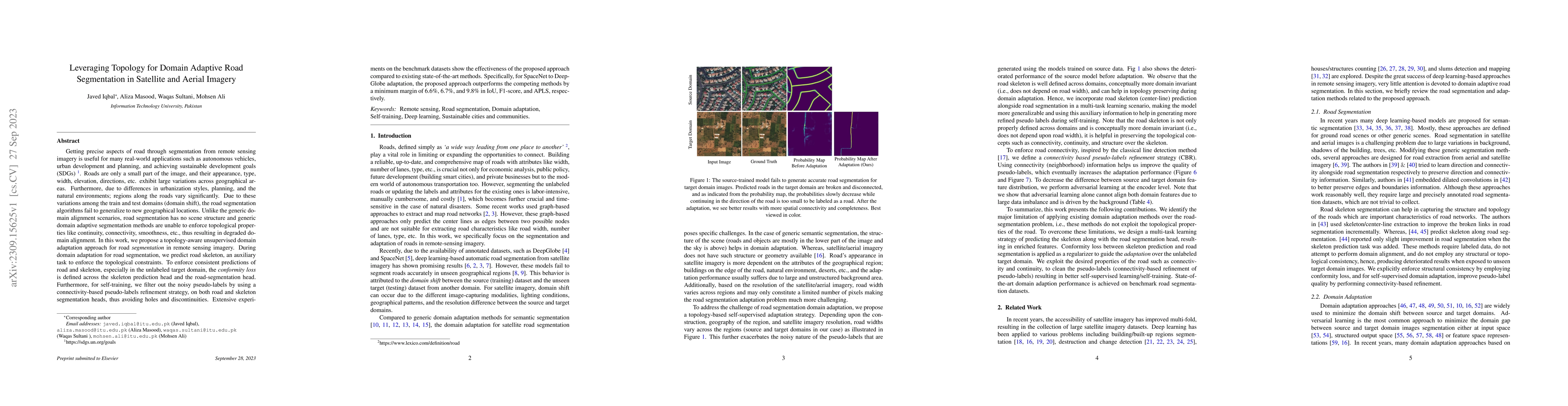
Getting precise aspects of road through segmentation from remote sensing imagery is useful for many real-world applications such as autonomous vehicles, urban development and planning, and achieving sustainable development goals. Roads are only a small part of the image, and their appearance, type, width, elevation, directions, etc. exhibit large variations across geographical areas. Furthermore, due to differences in urbanization styles, planning, and the natural environments; regions along the roads vary significantly. Due to these variations among the train and test domains, the road segmentation algorithms fail to generalize to new geographical locations. Unlike the generic domain alignment scenarios, road segmentation has no scene structure, and generic domain adaptation methods are unable to enforce topological properties like continuity, connectivity, smoothness, etc., thus resulting in degraded domain alignment. In this work, we propose a topology-aware unsupervised domain adaptation approach for road segmentation in remote sensing imagery. Specifically, we predict road skeleton, an auxiliary task to impose the topological constraints. To enforce consistent predictions of road and skeleton, especially in the unlabeled target domain, the conformity loss is defined across the skeleton prediction head and the road-segmentation head. Furthermore, for self-training, we filter out the noisy pseudo-labels by using a connectivity-based pseudo-labels refinement strategy, on both road and skeleton segmentation heads, thus avoiding holes and discontinuities. Extensive experiments on the benchmark datasets show the effectiveness of the proposed approach compared to existing state-of-the-art methods. Specifically, for SpaceNet to DeepGlobe adaptation, the proposed approach outperforms the competing methods by a minimum margin of 6.6%, 6.7%, and 9.8% in IoU, F1-score, and APLS, respectively.
AI Key Findings
Get AI-generated insights about this paper's methodology, results, and significance.
Paper Details
PDF Preview
Key Terms
Citation Network
Current paper (gray), citations (green), references (blue)
Display is limited for performance on very large graphs.
Similar Papers
Found 4 papersWeakly Supervised Domain Adaptation for Built-up Region Segmentation in Aerial and Satellite Imagery
AF$_2$: Adaptive Focus Framework for Aerial Imagery Segmentation
Jiang Bian, Lijun Wu, Tie-Yan Liu et al.
Brightearth roads: Towards fully automatic road network extraction from satellite imagery
Liuyun Duan, Willard Mapurisa, Maxime Leras et al.
| Title | Authors | Year | Actions |
|---|
Comments (0)