LIDAR data based Segmentation and Localization using Open Street Maps for Rural Roads
Publication
Metrics
AI Quick Summary
A new method for accurately localizing self-driving cars in rural areas using LIDAR data and Open Street Maps is proposed, achieving a mean accuracy of 6.5 meters within a 2 sq. km area.
Paper Preview
Abstract
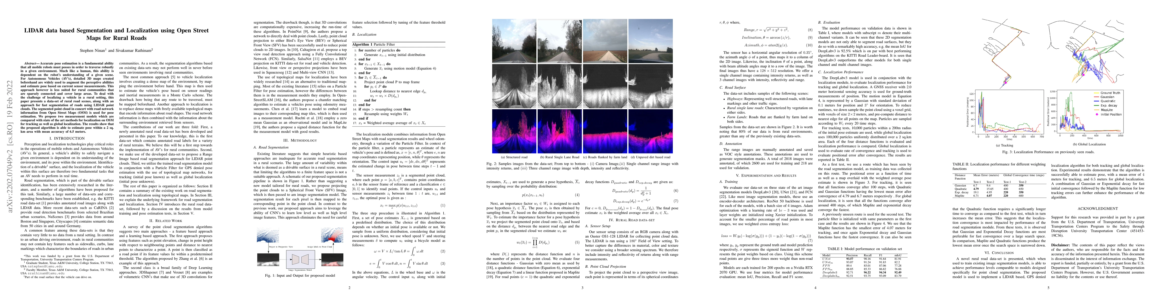
Accurate pose estimation is a fundamental ability that all mobile robots must posses in order to traverse robustly in a given environment. Much like a human, this ability is dependent on the robot's understanding of a given scene. For Autonomous Vehicles (AV's), detailed 3D maps created beforehand are widely used to augment the perceptive abilities and estimate pose based on current sensor measurements. This approach however is less suited for rural communities that are sparsely connected and cover large areas. To deal with the challenge of localizing a vehicle in a rural setting, this paper presents a data-set of rural road scenes, along with an approach for fast segmentation of roads using LIDAR point clouds. The segmented point cloud in concert with road network information from Open Street Maps (OSM) is used for pose estimation. We propose two measurement models which are compared with state of the art methods for localization on OSM for tracking as well as global localization. The results show that the proposed algorithm is able to estimate pose within a 2 sq. km area with mean accuracy of 6.5 meters.
AI Key Findings
Get AI-generated insights about this paper's methodology, results, significance, and more — seven facets brought into focus.
Impact
Paper Details
Authors
PDF Preview
Key Terms
Citation Network
Current paper (gray), citations (green), references (blue)
Display is limited for performance on very large graphs.
Discussion 0