LiDAR-GS:Real-time LiDAR Re-Simulation using Gaussian Splatting

Source: ArXiv

AI Quick Summary

LiDAR-GS introduces a novel Gaussian Splatting method for real-time, high-fidelity re-simulation of LiDAR scans, addressing limitations of existing methods. It employs differentiable laser beam splatting and Neural Gaussian Fields to achieve state-of-the-art frame rates and quality in simulating LiDAR properties and scenes.

Share: Share on X LinkedIn

Summary

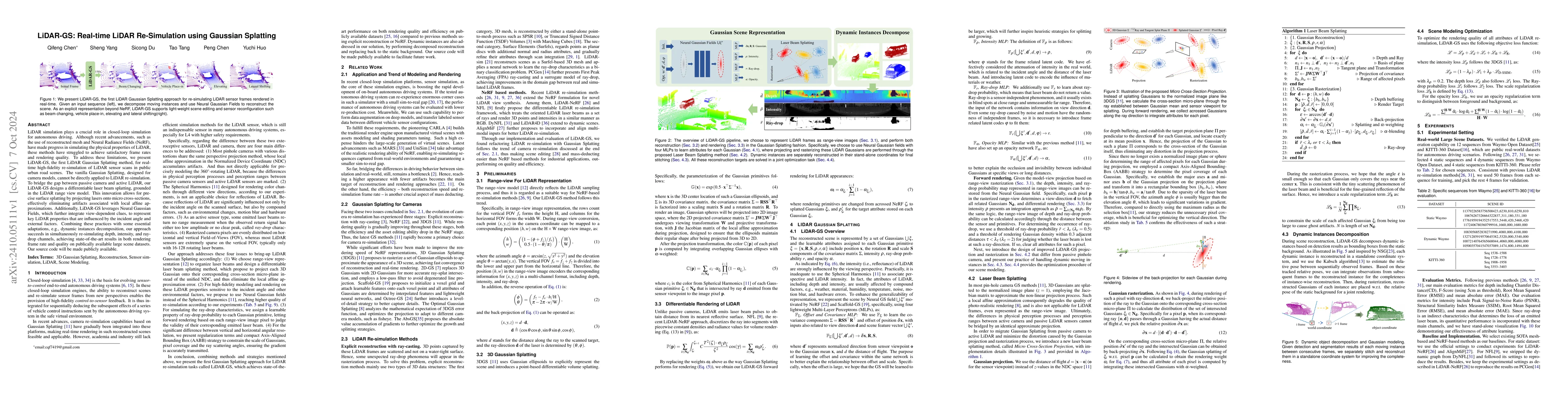
LiDAR simulation plays a crucial role in closed-loop simulation for autonomous driving. Although recent advancements, such as the use of reconstructed mesh and Neural Radiance Fields (NeRF), have made progress in simulating the physical properties of LiDAR, these methods have struggled to achieve satisfactory frame rates and rendering quality. To address these limitations, we present LiDAR-GS, the first LiDAR Gaussian Splatting method, for real-time high-fidelity re-simulation of LiDAR sensor scans in public urban road scenes. The vanilla Gaussian Splatting, designed for camera models, cannot be directly applied to LiDAR re-simulation. To bridge the gap between passive camera and active LiDAR, our LiDAR-GS designs a differentiable laser beam splatting, grounded in the LiDAR range view model. This innovation allows for precise surface splatting by projecting lasers onto micro cross-sections, effectively eliminating artifacts associated with local affine approximations. Additionally, LiDAR-GS leverages Neural Gaussian Fields, which further integrate view-dependent clues, to represent key LiDAR properties that are influenced by the incident angle and external factors. Combining these practices with some essential adaptations, e.g., dynamic instances decomposition, our approach succeeds in simultaneously re-simulating depth, intensity, and ray-drop channels, achieving state-of-the-art results in both rendering frame rate and quality on publically available large scene datasets. Our source code will be made publicly available.

AI Key Findings

Generated Sep 03, 2025

Methodology

The research introduces LiDAR-GS, a method for real-time high-fidelity re-simulation of LiDAR sensor scans using Gaussian Splatting, specifically designed for urban road scenes. It proposes differentiable laser beam splatting based on micro cross-section planes, Neural Gaussian Representation (NGR) for precise simulation of LiDAR properties, and strategies like AABB for projection constraints and spatial scale regularization.

Key Results

  • LiDAR-GS achieves state-of-the-art results in both rendering frame rate and quality on public large scene datasets.
  • The method successfully re-simulates depth, intensity, and ray-drop channels simultaneously.
  • LiDAR-GS outperforms existing explicit reconstruction and NeRF methods in terms of training and inference costs, reaching real-time rendering for LiDAR re-simulation tasks.
  • The approach demonstrates remarkable performance on most evaluation metrics for dynamic scenes, underscoring the realism of the re-simulated LiDAR scans.
  • LiDAR-GS shows effectiveness in novel view synthesis, adjusting free-viewpoint by lateral shifting, elevation, or changing the number of laser beams.

Significance

This research is significant as it bridges the gap between real-world LiDAR sensors and simulation, enabling large-scale realistic re-simulation of urban road scenes at high frame rates, which is crucial for autonomous driving development and testing.

Technical Contribution

LiDAR-GS introduces a novel differentiable laser beam splatting method based on micro cross-section planes, Neural Gaussian Representation for precise simulation of LiDAR properties, and strategies like AABB for projection constraints and spatial scale regularization.

Novelty

LiDAR-GS stands out as the first LiDAR Gaussian Splatting method designed for real-time high-fidelity re-simulation, addressing limitations of previous methods by proposing innovative laser beam splatting and integrating Neural Gaussian Representation to precisely simulate LiDAR properties.

Limitations

  • The method might struggle with sparse initialization in occluded or distant areas, potentially affecting performance on certain metrics like CD.
  • Two-stage convolutional network optimization could impact intensity rendering accuracy compared to methods like LiDAR4D.

Future Work

  • Explore methods to improve initialization in occluded or distant areas for better performance on CD metric.
  • Investigate alternative network architectures to enhance intensity rendering accuracy in LiDAR-GS.

Paper Details

PDF Preview

Download PDF

Citation Network

Current paper (gray), citations (green), references (blue)

Display is limited for performance on very large graphs.

Current Paper
Citations
References
Click to view

Similar Papers

Found 4 papers
Title Authors Year Actions

Comments (0)

This website uses cookies to ensure you get the best experience. Learn more