Quick Summary:

This paper presents LiGSM, a LiDAR-enhanced 3D Gaussian Splatting Mapping framework that integrates LiDAR data to improve 3D scene mapping accuracy and robustness. It leverages joint loss from images and LiDAR point clouds to optimize sensor alignment and initializes 3DGS with denser LiDAR points for better scene rendering.

Summary

This paper introduces LiGSM, a novel LiDAR-enhanced 3D Gaussian Splatting (3DGS) mapping framework that improves the accuracy and robustness of 3D scene mapping by integrating LiDAR data. LiGSM constructs joint loss from images and LiDAR point clouds to estimate the poses and optimize their extrinsic parameters, enabling dynamic adaptation to variations in sensor alignment. Furthermore, it leverages LiDAR point clouds to initialize 3DGS, providing a denser and more reliable starting points compared to sparse SfM points. In scene rendering, the framework augments standard image-based supervision with depth maps generated from LiDAR projections, ensuring an accurate scene representation in both geometry and photometry. Experiments on public and self-collected datasets demonstrate that LiGSM outperforms comparative methods in pose tracking and scene rendering.

AI Key Findings

Generated Jun 10, 2025

Methodology

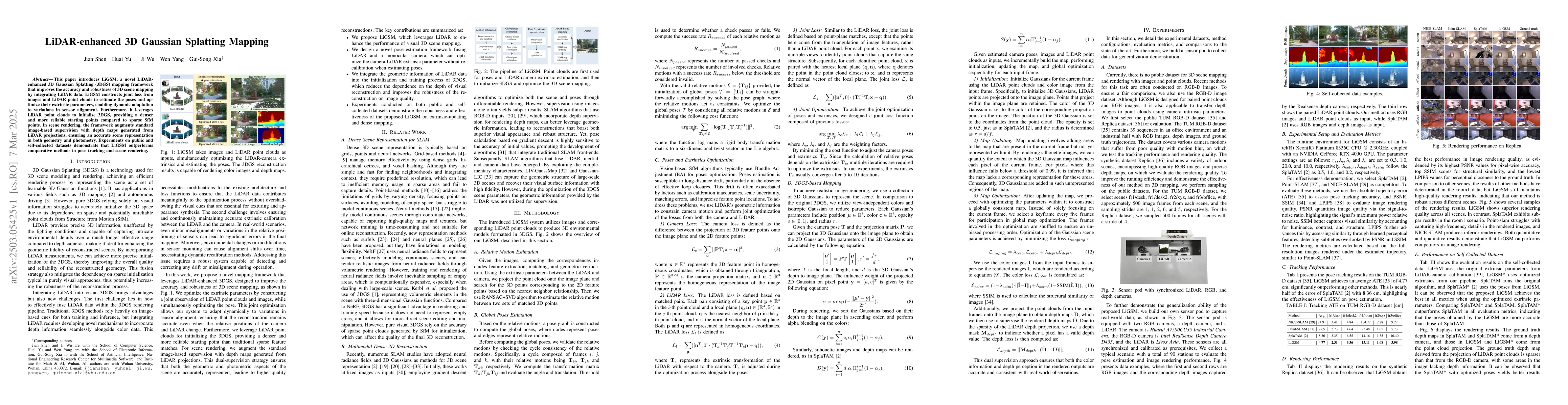
LiGSM utilizes images and corresponding LiDAR point clouds to produce 3D environmental models formatted in 3D Gaussian Splattering (3DGS). It involves relative motion estimation using feature extraction, matching, and geometric verification, followed by global pose estimation through pose graph construction and validation. LiDAR's geometric information is used to constrain camera motion and perform joint optimization of losses from both camera and LiDAR. 3DGS-based mapping is achieved using a collection of 3D Gaussians, which are projected onto the image plane for rendering, ensuring accurate color and depth information.

Key Results

  • LiGSM achieves an average ATE of 4.77 cm on the TUM RGB-D dataset, significantly outperforming other methods like SplaTAM (8.36 cm), Point-SLAM (7.65 cm), and NICE-SLAM (24.91 cm, 13.41 cm, 14.84 cm, 104.77 cm, 9.27 cm).
  • On the synthetic Replica dataset, LiGSM obtains the best performance in image rendering quality, evidenced by its highest PSNR values, top SSIM scores, and lowest LPIPS values compared to SplaTAM, Point-SLAM, and NICE-SLAM.
  • Using optimized extrinsics from the LiGSM pipeline on the self-collected dataset, LiGSM outperforms SplaTAM and SplaTAM* in all evaluation metrics, demonstrating the accuracy of LiGSM-derived poses.
  • LiGSM, even with sparse LiDAR points, shows the best depth rendering with dense depth information and the highest similarity to the ground truth, indicating its effectiveness in using sparse LiDAR points.
  • LiGSM completes the missed depth information without LiDAR point input, demonstrating its robustness.

Significance

This research is significant as it proposes a LiDAR-enhanced 3D Gaussian Splattering-based mapping pipeline that integrates geometric information from LiDAR point clouds with textural information from images for high-precision and high-quality 3D scene mapping. The method robustly optimizes joint observations of images and point clouds, achieving effective LiDAR-camera extrinsic parameter optimization and pose estimation, which is crucial for autonomous navigation and mapping applications.

Technical Contribution

The technical contribution of this work is the development of LiGSM, a novel framework that enhances 3D Gaussian Splattering mapping by integrating LiDAR data, leading to improved accuracy and robustness in 3D scene mapping through joint loss optimization from images and LiDAR point clouds.

Novelty

LiGSM's novelty lies in its approach to leverage LiDAR data for initializing 3D Gaussian Splattering, providing denser and more reliable starting points compared to sparse SfM points. Additionally, it augments standard image-based supervision with depth maps generated from LiDAR projections, ensuring accurate scene representation in both geometry and photometry.

Limitations

  • The paper does not explicitly discuss limitations, but potential limitations could include computational complexity, dependency on high-quality LiDAR and camera data, and the need for calibration between sensors.
  • The method's performance in highly dynamic or cluttered environments might require further investigation.

Future Work

  • Exploring the scalability of LiGSM in large-scale scenarios to ensure efficient and meticulous mapping.
  • Improving the computational speed of LiGSM to meet real-time application demands.

Paper Details

PDF Preview

Download PDF

Key Terms

No key terms available for this paper.

Citation Network

Current paper (gray), citations (green), references (blue)

Current Paper
Citations
References
Click to view

No citations found for this paper.

Comments (0)

This website uses cookies to ensure you get the best experience. Learn more