Authors
Summary
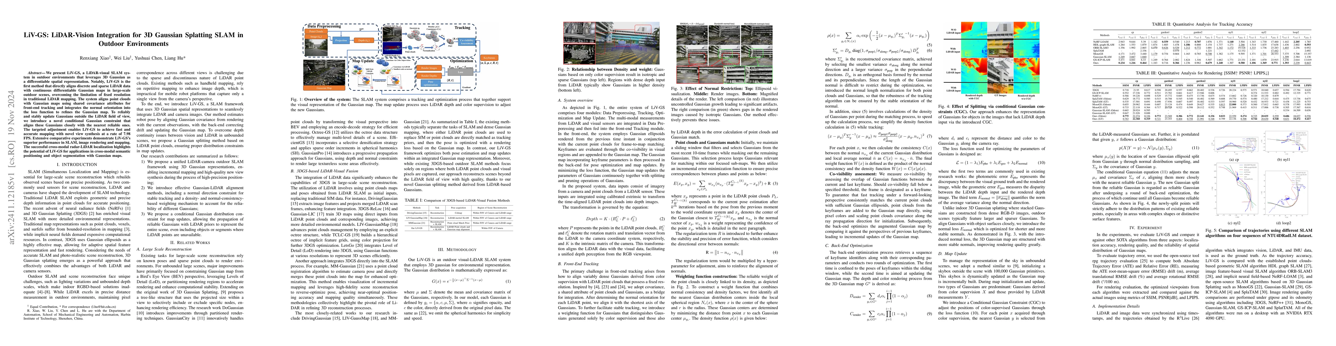
We present LiV-GS, a LiDAR-visual SLAM system in outdoor environments that leverages 3D Gaussian as a differentiable spatial representation. Notably, LiV-GS is the first method that directly aligns discrete and sparse LiDAR data with continuous differentiable Gaussian maps in large-scale outdoor scenes, overcoming the limitation of fixed resolution in traditional LiDAR mapping. The system aligns point clouds with Gaussian maps using shared covariance attributes for front-end tracking and integrates the normal orientation into the loss function to refines the Gaussian map. To reliably and stably update Gaussians outside the LiDAR field of view, we introduce a novel conditional Gaussian constraint that aligns these Gaussians closely with the nearest reliable ones. The targeted adjustment enables LiV-GS to achieve fast and accurate mapping with novel view synthesis at a rate of 7.98 FPS. Extensive comparative experiments demonstrate LiV-GS's superior performance in SLAM, image rendering and mapping. The successful cross-modal radar-LiDAR localization highlights the potential of LiV-GS for applications in cross-modal semantic positioning and object segmentation with Gaussian maps.
AI Key Findings
Get AI-generated insights about this paper's methodology, results, and significance.
Paper Details
PDF Preview
Similar Papers
Found 4 papersStereo 3D Gaussian Splatting SLAM for Outdoor Urban Scenes
Dong Liu, Fabio Tosi, Matteo Poggi et al.
GS-SLAM: Dense Visual SLAM with 3D Gaussian Splatting
Dong Wang, Zhigang Wang, Bin Zhao et al.
LVI-GS: Tightly-coupled LiDAR-Visual-Inertial SLAM using 3D Gaussian Splatting
Peng Lu, Weipeng Guan, Huibin Zhao
RGB-Only Gaussian Splatting SLAM for Unbounded Outdoor Scenes
Hao Wang, Yifan Zhou, Xiaojun Yang et al.
No citations found for this paper.
Comments (0)