LOGOS treats the road surface as a continuous mixture of 2D Gaussian primitives and performs a backpropagation-free LiDAR-only pipeline. It uses a freespace-aware initialization to incrementally prune non-road Gaussians via smoothness constraints, followed by a novel normal-aware elevation splatting function to compute pointwise signed distances by blending nearby Gaussians weighted by horizontal Mahalanobis distance.
LOGOS: LiDAR-Only Gaussian Elevation Splatting for Unified Tiny Obstacle Segmentation
Publication
Metrics
Quick Answers
What methodology did the authors use?
LOGOS treats the road surface as a continuous mixture of 2D Gaussian primitives and performs a backpropagation-free LiDAR-only pipeline. It uses a freespace-aware initialization to incrementally prune non-road Gaussians via smoothness constraints, followed by a novel normal-aware elevation splatting function to compute pointwise signed distances by blending nearby Gaussians weighted by horizontal Mahalanobis distance. More in Methodology →
What are the key results?
LOGOS significantly improves tiny obstacle segmentation accuracy in degraded point cloud regions and challenging off-road scenarios compared with state-of-the-art methods. — The approach maintains real-time efficiency, achieving faster initialization and pruning stages than baselines while keeping overall runtime competitive on road and off-road datasets. More in Key Results →
Why is this work significant?
Introduces the first LiDAR-only Gaussian elevation splatting method for unified tiny obstacle segmentation, addressing the limitations of fixed-parametric and discrete-grid road models in degraded LiDAR scans and off-road environments, while preserving real-time performance. More in Significance →
What are the main limitations?
Real-time gains are partly dataset- and sensor-dependent; extremely high point densities may increase per-frame computations. — The method relies on Gaussian-based road surface modeling which may struggle in highly irregular or non-Gaussian road geometries not well represented by primitives. More in Limitations →
Abstract
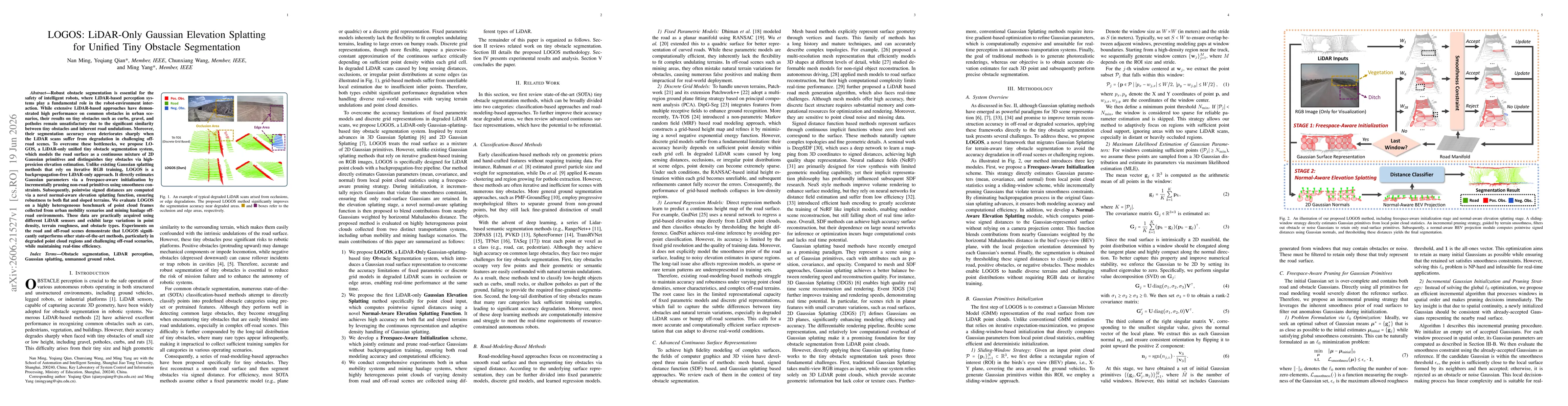
Robust obstacle segmentation is essential for the safety of intelligent robots, where LiDAR-based perception systems play a fundamental role in the robot-environment interaction. While extensive LiDAR-based approaches have demonstrated high performance on common obstacles in urban scenarios, their results on tiny obstacles such as curbs, gravel, and potholes remain unsatisfactory due to the significant similarity between tiny obstacles and inherent road undulations. Moreover, their segmentation accuracy even deteriorates sharply when the LiDAR scans suffer from degradation in challenging off-road scenes. To overcome these bottlenecks, we propose LOGOS, a LiDAR-only unified tiny obstacle segmentation system, which models the road surface as a continuous mixture of 2D Gaussian primitives and distinguishes tiny obstacles via high-presicion elevation estimation. Unlike existing Gaussian splatting methods that rely on iterative RGB training, LOGOS is a backpropagation-free LiDAR-only approach. It directly estimates Gaussian parameters via a freespace-aware initialization by incrementally pruning non-road primitives using smoothness constraints. Subsequently, pointwise signed distances are computed via a novel normal-aware elevation splatting function, ensuring robustness to both flat and sloped terrains. We evaluate LOGOS on a highly heterogeneous benchmark of point cloud frames collected from urban mobility scenarios and mining haulage off-road environments. These data are practically acquired using different LiDAR sensors and exhibit large variations in point density, terrain roughness, and obstacle types. Experiments on the road and off-road scenes demonstrate that LOGOS significantly outperforms other state-of-the-art methods, particularly in degraded point cloud regions and challenging off-road scenarios, while maintaining real-time efficiency.
Key Findings, in focus
Seven facets of this paper, analysed and brought into focus by AI.
Introduces the first LiDAR-only Gaussian elevation splatting method for unified tiny obstacle segmentation, addressing the limitations of fixed-parametric and discrete-grid road models in degraded LiDAR scans and off-road environments, while preserving real-time performance.
- LOGOS significantly improves tiny obstacle segmentation accuracy in degraded point cloud regions and challenging off-road scenarios compared with state-of-the-art methods.
- The approach maintains real-time efficiency, achieving faster initialization and pruning stages than baselines while keeping overall runtime competitive on road and off-road datasets.
- Experiments across urban mobility and mining haulage scenes with heterogeneous LiDAR data demonstrate robustness to varying point densities and terrain roughness.
Introduces the first LiDAR-only Gaussian elevation splatting method for unified tiny obstacle segmentation, addressing the limitations of fixed-parametric and discrete-grid road models in degraded LiDAR scans and off-road environments, while preserving real-time performance.
Proposes a backpropagation-free LiDAR-only pipeline that (1) models roads as a continuous Gaussian mixture with freespace-aware initialization and pruning, (2) introduces a normal-aware elevation splatting function for accurate pointwise signed distances, and (3) demonstrates real-time capable tiny obstacle segmentation across road and off-road scenarios.
First LiDAR-only Gaussian elevation splatting method for Tiny Obstacle Segmentation that eliminates RGB-based backpropagation, enabling continuous road surface representation and robust tiny obstacle discrimination in degraded LiDAR conditions.
- Real-time gains are partly dataset- and sensor-dependent; extremely high point densities may increase per-frame computations.
- The method relies on Gaussian-based road surface modeling which may struggle in highly irregular or non-Gaussian road geometries not well represented by primitives.
- Evaluation in extremely dense urban scenes with occlusions may require further optimization to sustain peak throughput.
- Extend LOGOS to dynamically adapt the number and size of Gaussians based on local surface complexity.
- Investigate integration with multi-sensor data (e.g., cameras) while preserving LiDAR-only advantages.
- Explore adaptive weighting schemes in the normal-aware elevation splatting to handle extreme terrain slopes.
Discussion 0