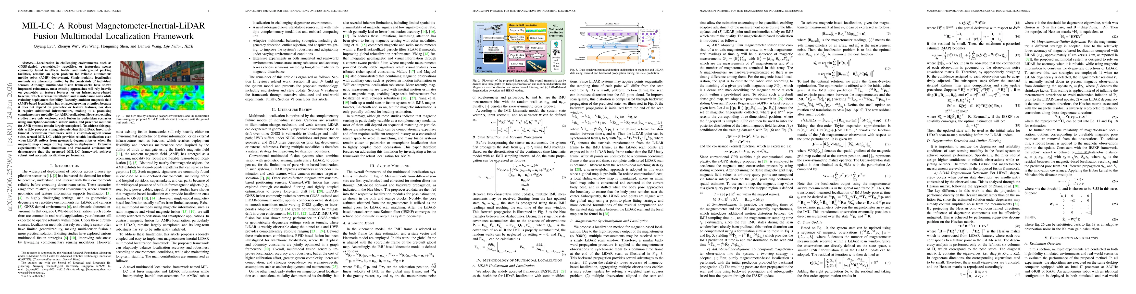
MIL-LC presents a loosely coupled multimodal localization framework that fuses magnetometer (AMF) data, LiDAR scans, and inertial measurements. Measurements from different sensors are time-synchronized and corrected for motion distortion using IMU-forward and backward propagation. The magnetometer-based pose estimate seeds LiDAR scan matching, after which an Iterated Extended Kalman Filter (IESKF) refines the pose to produce system odometry. The framework includes a novel standalone sensor suite, degeneracy detection, outlier rejection, and adaptive weighting to balance LiDAR accuracy with magnetic robustness, enabling reliable localization in LiDAR-degenerate or magnetically disturbed environments. The global map is pre-built, and magnetic measurements are continuously fused to maintain localization accuracy even when the magnetic map changes over long-term deployment.
MIL-LC: A Robust Magnetometer-Inertial-LiDAR Fusion Multimodal Localization Framework
Publication
Metrics
Quick Answers
What methodology did the authors use?
MIL-LC presents a loosely coupled multimodal localization framework that fuses magnetometer (AMF) data, LiDAR scans, and inertial measurements. Measurements from different sensors are time-synchronized and corrected for motion distortion using IMU-forward and backward propagation. The magnetometer-based pose estimate seeds LiDAR scan matching, after which an Iterated Extended Kalman Filter (IESKF) refines the pose to produce system odometry. The framework includes... More in Methodology →
What are the key results?
MIL-LC achieves robust localization in challenging degenerate environments where LiDAR alone would struggle, maintaining low drift and stable pose estimates. — Experiments show strong long-term resilience to magnetic disturbances, with localization accuracy preserved when magnetic maps are perturbed or updated over time. More in Key Results →
Why is this work significant?
Provides a practical, infrastructure-free multimodal localization solution for autonomous mobile robots operating in GNSS-denied, geometrically repetitive, or textureless environments by combining magnetometer data with LiDAR and inertial sensing. Enhances long-term stability and robustness against magnetic map changes and environmental disturbances, reducing reliance on LiDAR alone. More in Significance →
What are the main limitations?
Dependence on a pre-built magnetic map and potential degradation if magnetic signatures change drastically beyond the framework’s adaptive capacity. — Performance may vary with sensor calibration quality and magnetometer noise, particularly in highly dynamic magnetic environments. More in Limitations →
Paper Preview
Abstract
Localization in challenging environments, such as GNSS-denied, geometrically repetitive, or textureless scenes commonly found in offices, hotels, and underground parking facilities, remains an open problem for reliable autonomous mobile robot (AMR) deployment. Single-modality localization methods are inherently limited by the constraints of individual sensors. Although multimodal fusion frameworks have shown improved robustness, most existing approaches still rely heavily on geometric or texture features, or on infrastructure-based beacons, which increase installation and maintenance costs while reducing deployment flexibility. Recently, ambient magnetic field (AMF)-based localization has attracted growing attention because it does not depend on geometric or texture features, nor does it require additional infrastructure, making it a promising complementary modality for AMR localization. However, existing studies have only explored such fusion in pedestrian scenarios using smartphone-mounted sensor suites, and practical solutions for AMR systems remain largely unexplored. To address this gap, this article proposes a magnetometer-inertial-LiDAR fused multimodal localization framework with a custom-designed sensor suite, termed MIL-LC, which provides reliable localization even when LiDAR suffers from geometric degeneration or when the magnetic map changes during long-term deployment. Extensive experiments in both simulation and real-world environments demonstrate that the proposed MIL-LC framework achieves robust and accurate localization performance.
Key Findings, in focus
Seven facets of this paper, analysed and brought into focus by AI.
Provides a practical, infrastructure-free multimodal localization solution for autonomous mobile robots operating in GNSS-denied, geometrically repetitive, or textureless environments by combining magnetometer data with LiDAR and inertial sensing.
- MIL-LC achieves robust localization in challenging degenerate environments where LiDAR alone would struggle, maintaining low drift and stable pose estimates.
- Experiments show strong long-term resilience to magnetic disturbances, with localization accuracy preserved when magnetic maps are perturbed or updated over time.
- Adaptive weighting and degeneracy detection effectively switch emphasis between modalities to preserve localization integrity under varying conditions.
- The framework demonstrates the ability to detect disturbed magnetic regions and provide clearer trajectories by leveraging the fused multimodal measurements.
Provides a practical, infrastructure-free multimodal localization solution for autonomous mobile robots operating in GNSS-denied, geometrically repetitive, or textureless environments by combining magnetometer data with LiDAR and inertial sensing. Enhances long-term stability and robustness against magnetic map changes and environmental disturbances, reducing reliance on LiDAR alone.
Introduces MIL-LC, a novel multimodal localization framework that fuses magnetometer, inertial, and LiDAR data with degeneracy detection and adaptive weighting. It also implements a new standalone sensor suite and demonstrates long-term robustness to magnetic disturbances and map changes.
Targets robust AMR localization by leveraging ambient magnetic field signatures in combination with LiDAR and IMU in a tightly integrated, adaptively balanced fusion framework, addressing long-term magnetic map disturbances and degeneracy scenarios where LiDAR-only approaches fail.
- Dependence on a pre-built magnetic map and potential degradation if magnetic signatures change drastically beyond the framework’s adaptive capacity.
- Performance may vary with sensor calibration quality and magnetometer noise, particularly in highly dynamic magnetic environments.
- Computational overhead from maintaining multiple modalities and adaptive weighting could impact real-time performance on resource-constrained platforms.
- Explore fully online magnetic map building and map update strategies to further improve robustness to long-term magnetic field changes.
- Investigate tighter coupling approaches between modalities to potentially improve observability in extreme degeneracy.
- Extend evaluation to more diverse environments (e.g., outdoor urban canyons, changing electromagnetic landscapes) and larger-scale deployments.
Discussion 0