MSDPN: Monocular Depth Prediction with Partial Laser Observation using Multi-stage Neural Networks
Publication
Metrics
AI Quick Summary
The paper proposes MSDPN, a multi-stage neural network for predicting dense depth maps using 2D LiDAR and monocular camera data, addressing partial observation issues. The network's Cross Stage Feature Aggregation enhances feature learning and inter-spatial relationships, outperforming state-of-the-art methods.
Paper Preview
Abstract
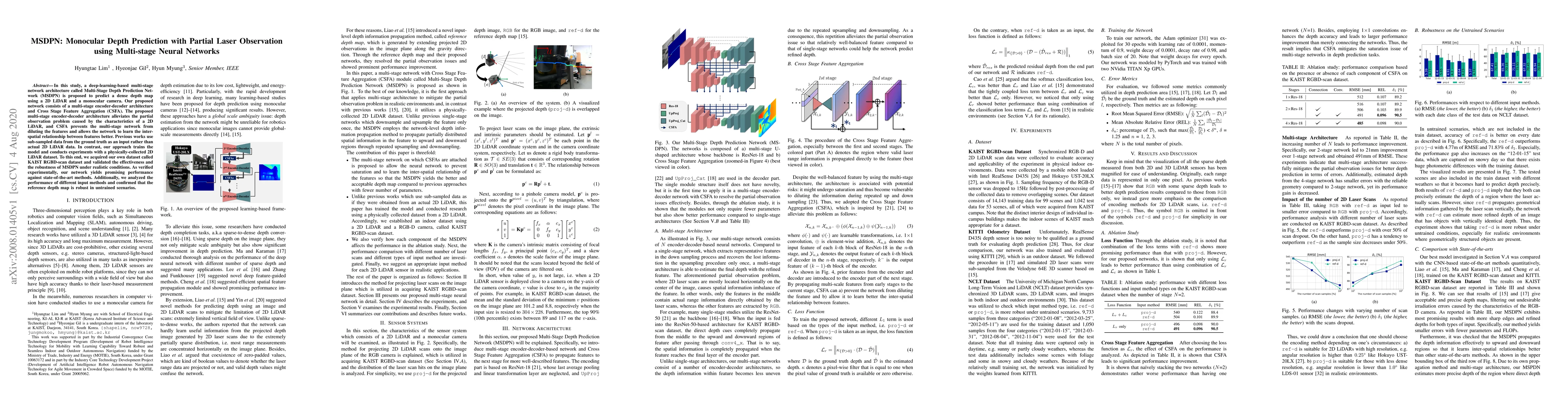
In this study, a deep-learning-based multi-stage network architecture called Multi-Stage Depth Prediction Network (MSDPN) is proposed to predict a dense depth map using a 2D LiDAR and a monocular camera. Our proposed network consists of a multi-stage encoder-decoder architecture and Cross Stage Feature Aggregation (CSFA). The proposed multi-stage encoder-decoder architecture alleviates the partial observation problem caused by the characteristics of a 2D LiDAR, and CSFA prevents the multi-stage network from diluting the features and allows the network to learn the inter-spatial relationship between features better. Previous works use sub-sampled data from the ground truth as an input rather than actual 2D LiDAR data. In contrast, our approach trains the model and conducts experiments with a physically-collected 2D LiDAR dataset. To this end, we acquired our own dataset called KAIST RGBD-scan dataset and validated the effectiveness and the robustness of MSDPN under realistic conditions. As verified experimentally, our network yields promising performance against state-of-the-art methods. Additionally, we analyzed the performance of different input methods and confirmed that the reference depth map is robust in untrained scenarios.
AI Key Findings
Get AI-generated insights about this paper's methodology, results, significance, and more — seven facets brought into focus.
Impact
Paper Details
Authors
PDF Preview
Key Terms
Citation Network
Current paper (gray), citations (green), references (blue)
Display is limited for performance on very large graphs.
Discussion 0