Authors
Publication
Metrics
Quick Actions
AI Quick Summary
This paper introduces a novel Bayesian inference framework using InSAR imagery to assess multi-class seismic building damage, achieving up to 35.7% improvement in accuracy over existing methods and reducing computational overhead by over 40%. The method integrates InSAR data with ground failure models, employing quadratic variational bounds for efficient signal separation.
Quick Answers
What is "Multi-class Seismic Building Damage Assessment from InSAR Imagery using Quadratic Variational Causal Bayesian Inference" about?
This paper introduces a novel Bayesian inference framework using InSAR imagery to assess multi-class seismic building damage, achieving up to 35.7% improvement in accuracy over existing methods and reducing computational overhead by over 40%. The method integrates InSAR data with ground failure models, employing quadratic variational bounds for efficient signal separation.
What methodology did the authors use?
The research employs a novel multi-class variational causal Bayesian inference framework with quadratic variational bounds for processing InSAR imagery data to classify building damage from earthquakes. It integrates InSAR observations with USGS ground failure models and building fragility functions, using an expectation-maximization algorithm and a pruning strategy based on building footprint information. More in Methodology →
What are the key results?
Improved damage classification accuracy (AUC: 0.94-0.96) compared to existing methods, with up to 35.7% improvement. — High accuracy (AUC > 0.93) across all damage categories maintained without requiring extensive ground truth data. More in Key Results →
Why is this work significant?
This research contributes to more reliable rapid post-earthquake damage assessment, which is crucial for emergency response planning and resource allocation. It addresses critical challenges in multi-class building damage assessment from InSAR data, such as overlapping damage signatures with environmental noise and computational complexity. More in Significance →
What are the main limitations?
The study was limited to five major earthquakes for evaluation, which may not fully capture the variability of all possible seismic events. — Reliance on ground failure models and building fragility functions, which may have limitations in regions with sparse features or unusual seismic patterns. More in Limitations →
Abstract
Interferometric Synthetic Aperture Radar (InSAR) technology uses satellite 
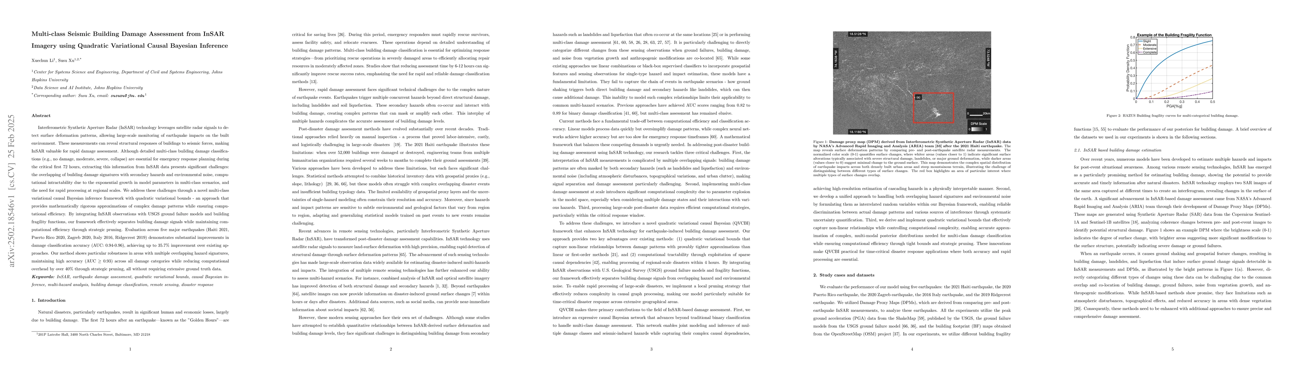
radar to detect surface deformation patterns and monitor earthquake impacts on buildings. While vital for emergency response planning, extracting multi-class building damage classifications from InSAR data faces challenges: overlapping damage signatures with environmental noise, computational complexity in multi-class scenarios, and the need for rapid regional-scale processing. Our novel multi-class variational causal Bayesian inference framework with quadratic variational bounds provides rigorous approximations while ensuring efficiency. By integrating InSAR observations with USGS ground failure models and building fragility functions, our approach separates building damage signals while maintaining computational efficiency through strategic pruning. Evaluation across five major earthquakes (Haiti 2021, Puerto Rico 2020, Zagreb 2020, Italy 2016, Ridgecrest 2019) shows improved damage classification accuracy (AUC: 0.94-0.96), achieving up to 35.7% improvement over existing methods. Our approach maintains high accuracy (AUC > 0.93) across all damage categories while reducing computational overhead by over 40% without requiring extensive ground truth data.
AI Key Findings
Generated Jun 11, 2025
Methodology — What approach did the authors take?
The research employs a novel multi-class variational causal Bayesian inference framework with quadratic variational bounds for processing InSAR imagery data to classify building damage from earthquakes. It integrates InSAR observations with USGS ground failure models and building fragility functions, using an expectation-maximization algorithm and a pruning strategy based on building footprint information.
Key Results — What are the main findings?
- Improved damage classification accuracy (AUC: 0.94-0.96) compared to existing methods, with up to 35.7% improvement.
- High accuracy (AUC > 0.93) across all damage categories maintained without requiring extensive ground truth data.
- 40% reduction in computational overhead achieved through strategic pruning.
- Robust performance across diverse urban contexts, including regular residential blocks, dense city centers, mixed urban-suburban areas, and coastal regions.
- Effective handling of poorly-performing prior models, demonstrating the ability to overcome regional variations in building vulnerability.
Significance — Why does this research matter?
This research contributes to more reliable rapid post-earthquake damage assessment, which is crucial for emergency response planning and resource allocation. It addresses critical challenges in multi-class building damage assessment from InSAR data, such as overlapping damage signatures with environmental noise and computational complexity.
Technical Contribution — What is the technical contribution?
The paper introduces a two-stage bounding approach for obtaining tight approximations in variational causal Bayesian inference, incorporating L-1 regularization to balance the influence of damage proxy maps (DPMs) and prior geospatial models.
Novelty — What is new about this work?
The novelty of this work lies in the integration of quadratic variational bounds with causal Bayesian inference for multi-class building damage assessment from InSAR imagery, along with a pruning strategy based on building footprint information to improve computational efficiency.
Limitations — What are the limitations of this study?
- The study was limited to five major earthquakes for evaluation, which may not fully capture the variability of all possible seismic events.
- Reliance on ground failure models and building fragility functions, which may have limitations in regions with sparse features or unusual seismic patterns.
Future Work — What did the authors propose for future work?
- Explore the application of the framework to other natural disasters and different remote sensing data sources.
- Investigate the scalability of the approach for real-time damage assessment during ongoing seismic events.
Paper Details
How to Cite This Paper
@article{xu2025multi,
title = {Multi-class Seismic Building Damage Assessment from InSAR Imagery using
Quadratic Variational Causal Bayesian Inference},
author = {Xu, Susu and Li, Xuechun},
year = {2025},
eprint = {2502.18546},
archivePrefix = {arXiv},
primaryClass = {cs.CV},
}
Xu, S., & Li, X. (2025). Multi-class Seismic Building Damage Assessment from InSAR Imagery using
Quadratic Variational Causal Bayesian Inference. arXiv. https://arxiv.org/abs/2502.18546
Xu, Susu, and Xuechun Li. "Multi-class Seismic Building Damage Assessment from InSAR Imagery using
Quadratic Variational Causal Bayesian Inference." arXiv, 2025, arxiv.org/abs/2502.18546.
PDF Preview
Citation Network
Current paper (gray), citations (green), references (blue)
Display is limited for performance on very large graphs.
Similar Papers
Found 4 papersNormalizing flow-based deep variational Bayesian network for seismic multi-hazards and impacts estimation from InSAR imagery
Xuechun Li, Paula M. Burgi, Wei Ma et al.
Causality-informed Rapid Post-hurricane Building Damage Detection in Large Scale from InSAR Imagery
Chenguang Wang, Yepeng Liu, Xiaojian Zhang et al.
RescueNet: Joint Building Segmentation and Damage Assessment from Satellite Imagery
Rohit Gupta, Mubarak Shah
Building Disaster Damage Assessment in Satellite Imagery with Multi-Temporal Fusion
Hassan Kané, Ethan Weber
No citations found for this paper.
Comments (0)