Online Fusion of Multi-resolution Multispectral Images with Weakly Supervised Temporal Dynamics
Publication
Metrics
AI Quick Summary
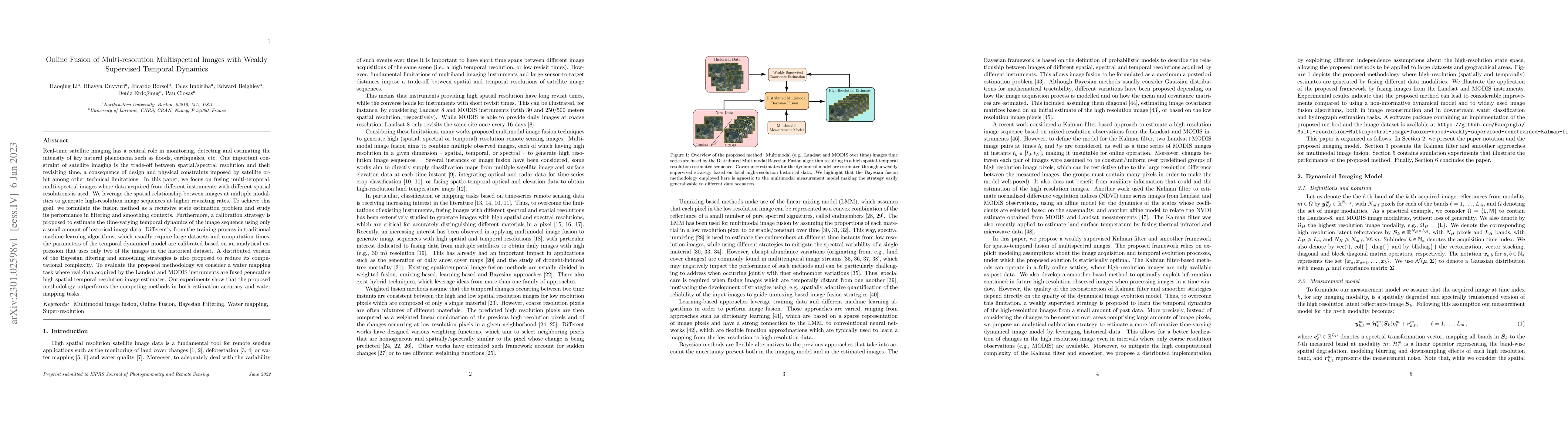
This paper presents a method for fusing multi-resolution, multispectral satellite images to generate high-resolution sequences with improved temporal revisit rates. It leverages spatial relationships and formulates the fusion as a recursive state estimation problem, employing a weakly supervised temporal dynamics calibration strategy to reduce computational complexity.
Paper Preview
Abstract
Real-time satellite imaging has a central role in monitoring, detecting and estimating the intensity of key natural phenomena such as floods, earthquakes, etc. One important constraint of satellite imaging is the trade-off between spatial/spectral resolution and their revisiting time, a consequence of design and physical constraints imposed by satellite orbit among other technical limitations. In this paper, we focus on fusing multi-temporal, multi-spectral images where data acquired from different instruments with different spatial resolutions is used. We leverage the spatial relationship between images at multiple modalities to generate high-resolution image sequences at higher revisiting rates. To achieve this goal, we formulate the fusion method as a recursive state estimation problem and study its performance in filtering and smoothing contexts. Furthermore, a calibration strategy is proposed to estimate the time-varying temporal dynamics of the image sequence using only a small amount of historical image data. Differently from the training process in traditional machine learning algorithms, which usually require large datasets and computation times, the parameters of the temporal dynamical model are calibrated based on an analytical expression that uses only two of the images in the historical dataset. A distributed version of the Bayesian filtering and smoothing strategies is also proposed to reduce its computational complexity. To evaluate the proposed methodology we consider a water mapping task where real data acquired by the Landsat and MODIS instruments are fused generating high spatial-temporal resolution image estimates. Our experiments show that the proposed methodology outperforms the competing methods in both estimation accuracy and water mapping tasks.
AI Key Findings
Get AI-generated insights about this paper's methodology, results, significance, and more — seven facets brought into focus.
Impact
Paper Details
Authors
PDF Preview
Key Terms
Citation Network
Current paper (gray), citations (green), references (blue)
Display is limited for performance on very large graphs.
Discussion 0