Summary
LiDAR place recognition is a critical capability for autonomous navigation and cross-modal localization in large-scale outdoor environments. Existing approaches predominantly depend on pre-built 3D dense maps or aerial imagery, which impose significant storage overhead and lack real-time adaptability. In this paper, we propose OPAL, a novel network for LiDAR place recognition that leverages OpenStreetMap (OSM) as a lightweight and up-to-date prior. Our key innovation lies in bridging the domain disparity between sparse LiDAR scans and structured OSM data through two carefully designed components. First, a cross-modal visibility mask that identifies maximal observable regions from both modalities to guide feature learning. Second, an adaptive radial fusion module that dynamically consolidates radial features into discriminative global descriptors. Extensive experiments on the KITTI and KITTI-360 datasets demonstrate OPAL's superiority, achieving 15.98% higher recall at @1m threshold for top-1 retrieved matches, along with 12x faster inference speed compared to the state-of-the-art approach. Code and datasets will be publicly available.
AI Key Findings
Generated Jun 09, 2025
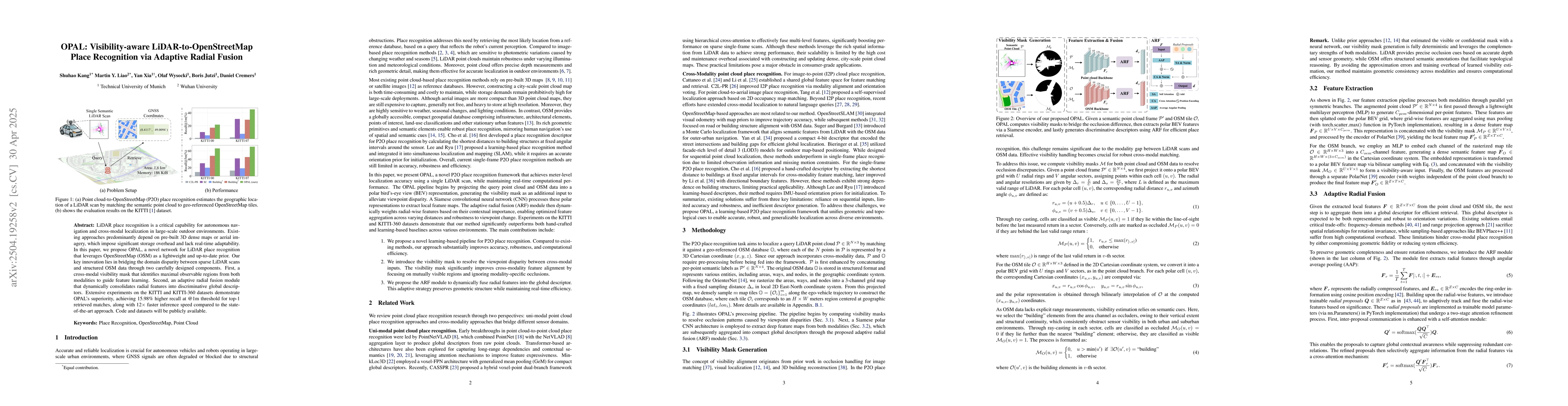
Methodology
The research proposes OPAL, a network for LiDAR place recognition that utilizes OpenStreetMap (OSM) data, addressing limitations of pre-built 3D dense maps or aerial imagery through visibility masks and adaptive radial fusion modules.
Key Results
- OPAL achieves 15.98% higher recall at @1m threshold for top-1 retrieved matches compared to state-of-the-art approaches.
- The method demonstrates 12x faster inference speed than existing techniques.
Significance
This research is significant for autonomous navigation and cross-modal localization, providing a lightweight, up-to-date, and efficient alternative to pre-built 3D maps or aerial imagery.
Technical Contribution
The paper introduces OPAL, a visibility-aware LiDAR-to-OSM place recognition method using a cross-modal visibility mask and adaptive radial fusion module.
Novelty
OPAL bridges the gap between sparse LiDAR scans and structured OSM data, offering a novel approach distinct from existing methods relying on dense 3D maps or aerial imagery.
Limitations
- The paper does not discuss limitations explicitly; however, reliance on OSM data might introduce inaccuracies if the map data is outdated or incomplete.
- Performance in highly dynamic or cluttered urban environments remains unexplored.
Future Work
- Investigate the method's performance in diverse and challenging environments.
- Explore integration with other map data sources for enhanced robustness.
Paper Details
PDF Preview
Similar Papers
Found 4 papersRanking-aware Continual Learning for LiDAR Place Recognition
Tiantian Feng, Junqiao Zhao, Qiankun Yu et al.
Uncertainty-Aware Lidar Place Recognition in Novel Environments
Dimity Miller, Peyman Moghadam, Milad Ramezani et al.
| Title | Authors | Year | Actions |
|---|
Comments (0)