Remote sensing images inevitably suffer from various degradation factors
during acquisition, including atmospheric interference, sensor limitations, and
imaging conditions. These complex and heterogeneous degradations pose severe
challenges to image quality and downstream interpretation tasks. Addressing
limitations of existing all-in-one restoration methods that overly rely on
implicit feature representations and lack explicit modeling of degradation
physics, this paper proposes Physics-Guided Degradation-Adaptive Experts
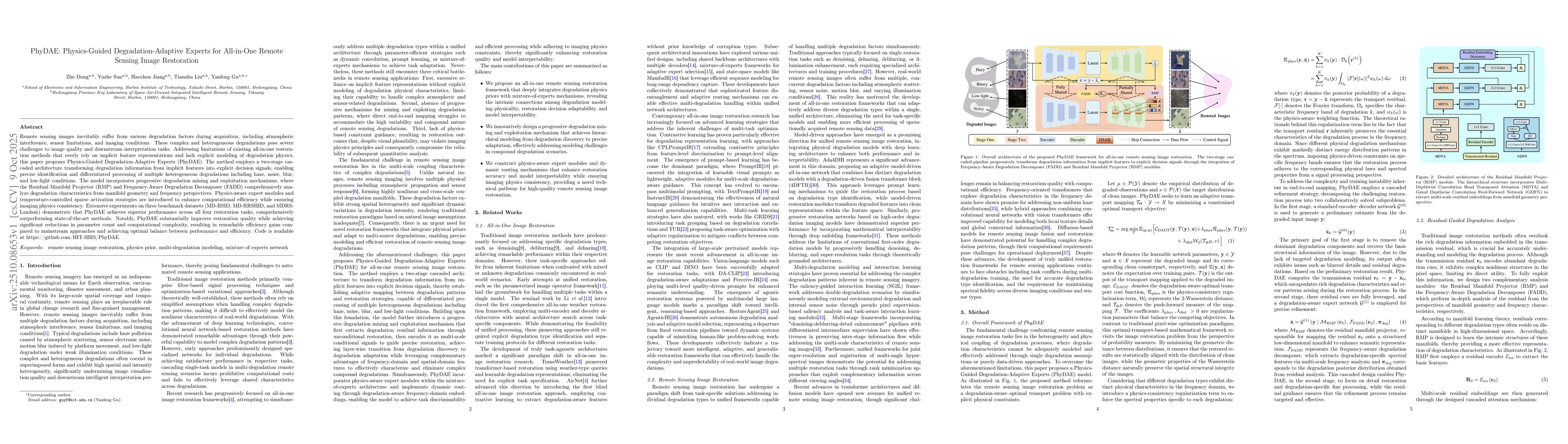
(PhyDAE). The method employs a two-stage cascaded architecture transforming
degradation information from implicit features into explicit decision signals,
enabling precise identification and differentiated processing of multiple
heterogeneous degradations including haze, noise, blur, and low-light
conditions. The model incorporates progressive degradation mining and
exploitation mechanisms, where the Residual Manifold Projector (RMP) and
Frequency-Aware Degradation Decomposer (FADD) comprehensively analyze
degradation characteristics from manifold geometry and frequency perspectives.
Physics-aware expert modules and temperature-controlled sparse activation
strategies are introduced to enhance computational efficiency while ensuring
imaging physics consistency. Extensive experiments on three benchmark datasets
(MD-RSID, MD-RRSHID, and MDRS-Landsat) demonstrate that PhyDAE achieves
superior performance across all four restoration tasks, comprehensively
outperforming state-of-the-art methods. Notably, PhyDAE substantially improves
restoration quality while achieving significant reductions in parameter count
and computational complexity, resulting in remarkable efficiency gains compared
to mainstream approaches and achieving optimal balance between performance and
efficiency. Code is available at https://github.com/HIT-SIRS/PhyDAE.
Discussion 0