pyrtklib: An open-source package for tightly coupled deep learning and GNSS integration for positioning in urban canyons
Publication
Metrics
AI Quick Summary
**Summary:** pyrtklib is an open-source Python package that bridges GNSS positioning algorithms with deep learning, aiming to enhance accuracy in urban environments. It integrates RTKLIB functionalities into Python, enabling the development of advanced deep learning-based GNSS algorithms.
Paper Preview
Abstract
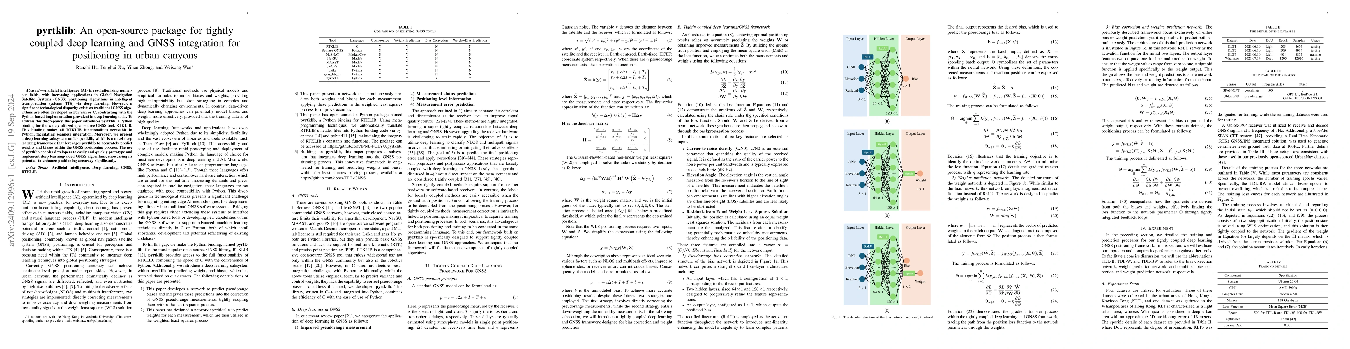
Artificial intelligence (AI) is revolutionizing numerous fields, with increasing applications in Global Navigation Satellite Systems (GNSS) positioning algorithms in intelligent transportation systems (ITS) via deep learning. However, a significant technological disparity exists as traditional GNSS algorithms are often developed in Fortran or C, contrasting with the Python-based implementation prevalent in deep learning tools. To address this discrepancy, this paper introduces pyrtklib, a Python binding for the widely utilized open-source GNSS tool, RTKLIB. This binding makes all RTKLIB functionalities accessible in Python, facilitating seamless integration. Moreover, we present a deep learning subsystem under pyrtklib, which is a novel deep learning framework that leverages pyrtklib to accurately predict weights and biases within the GNSS positioning process. The use of pyrtklib enables developers to easily and quickly prototype and implement deep learning-aided GNSS algorithms, showcasing its potential to enhance positioning accuracy significantly.
AI Key Findings
Get AI-generated insights about this paper's methodology, results, significance, and more — seven facets brought into focus.
Impact
Authors
PDF Preview
Citation Network
Current paper (gray), citations (green), references (blue)
Display is limited for performance on very large graphs.
Discussion 0