Publication
Metrics
AI Quick Summary
This paper develops a data-driven, network-based method to quantify urban life quality through walkability in Budapest, introducing a Life Quality Index (LQI) based on pedestrian accessibility, safety, and environmental factors. The approach offers a granular measurement tool for urban planners and can be generalized to other cities.
Paper Preview
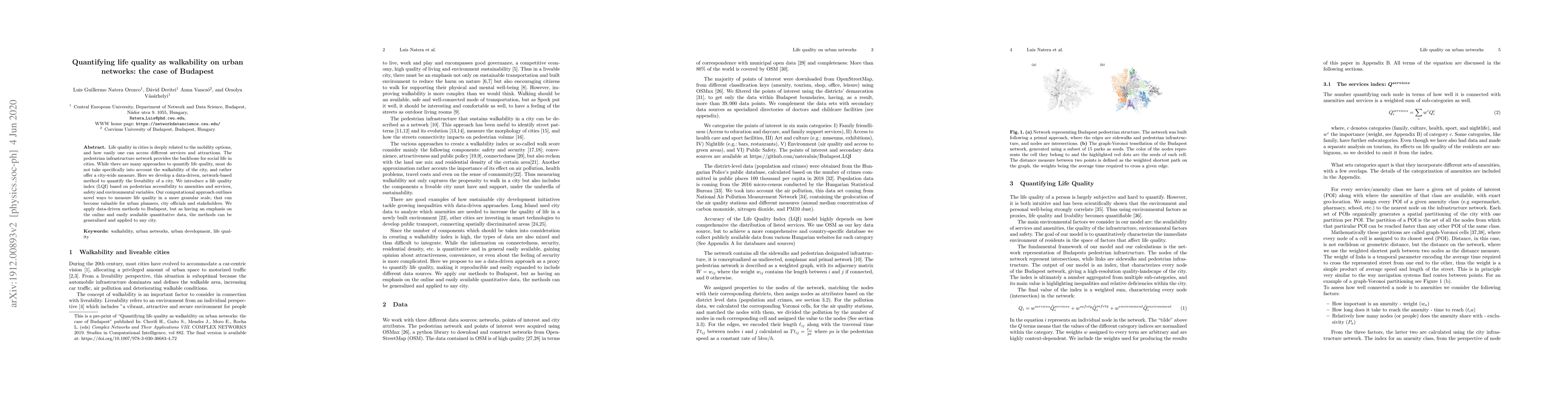
Abstract
Life quality in cities is deeply related to the mobility options, and how easily one can access different services and attractions. The pedestrian infrastructure network provides the backbone for social life in cities. While there are many approaches to quantify life quality, most do not take specifically into account the walkability of the city, and rather offer a city-wide measure. Here we develop a data-driven, network-based method to quantify the liveability of a city. We introduce a life quality index (LQI) based on pedestrian accessibility to amenities and services, safety and environmental variables. Our computational approach outlines novel ways to measure life quality in a more granular scale, that can become valuable for urban planners, city officials and stakeholders. We apply data-driven methods to Budapest, but as having an emphasis on the online and easily available quantitative data, the methods can be generalized and applied to any city.
AI Key Findings
Get AI-generated insights about this paper's methodology, results, significance, and more — seven facets brought into focus.
Impact
Paper Details
PDF Preview
Key Terms
Citation Network
Current paper (gray), citations (green), references (blue)
Display is limited for performance on very large graphs.
Discussion 0