QuickQuakeBuildings: Post-earthquake SAR-Optical Dataset for Quick Damaged-building Detection
Publication
Metrics
AI Quick Summary
This paper introduces a new dataset for detecting earthquake-damaged buildings using post-event high-resolution SAR and optical satellite imagery from the 2023 Turkey-Syria earthquakes. The dataset includes coregistered building footprints and image patches, aiming to expedite algorithm development for rapid damaged building detection.
Paper Preview
Abstract
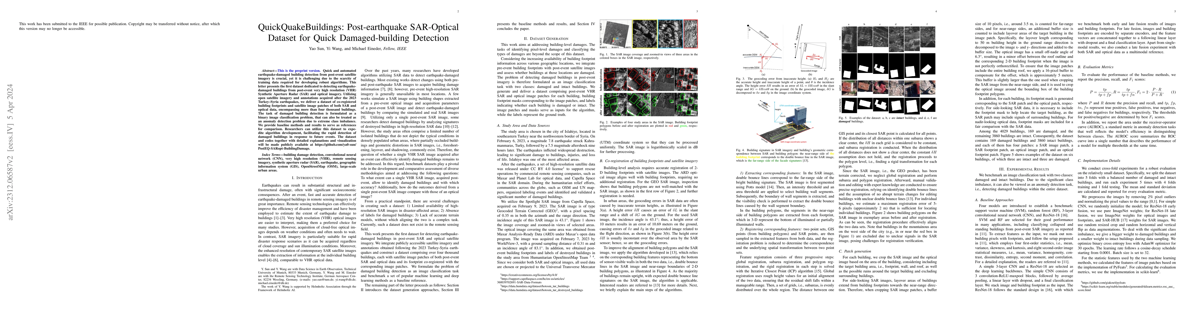
Quick and automated earthquake-damaged building detection from post-event satellite imagery is crucial, yet it is challenging due to the scarcity of training data required to develop robust algorithms. This letter presents the first dataset dedicated to detecting earthquake-damaged buildings from post-event very high resolution (VHR) Synthetic Aperture Radar (SAR) and optical imagery. Utilizing open satellite imagery and annotations acquired after the 2023 Turkey-Syria earthquakes, we deliver a dataset of coregistered building footprints and satellite image patches of both SAR and optical data, encompassing more than four thousand buildings. The task of damaged building detection is formulated as a binary image classification problem, that can also be treated as an anomaly detection problem due to extreme class imbalance. We provide baseline methods and results to serve as references for comparison. Researchers can utilize this dataset to expedite algorithm development, facilitating the rapid detection of damaged buildings in response to future events. The dataset and codes together with detailed explanations and visualization are made publicly available at \url{https://github.com/ya0-sun/PostEQ-SARopt-BuildingDamage}.
AI Key Findings
Get AI-generated insights about this paper's methodology, results, significance, and more — seven facets brought into focus.
Impact
Paper Details
Authors
PDF Preview
Key Terms
Citation Network
Current paper (gray), citations (green), references (blue)
Display is limited for performance on very large graphs.
Discussion 0