Quick Summary:

This paper introduces RCPCC, a novel framework for real-time LiDAR point cloud compression and transmission, addressing the challenges of data storage and transmission in resource-constrained robots. The method iteratively fits surfaces, eliminates redundancy, and uses Shape-adaptive DCT for data volume reduction, achieving compression rates of 40$\times$ to 80$\times$ while maintaining high accuracy.

Summary

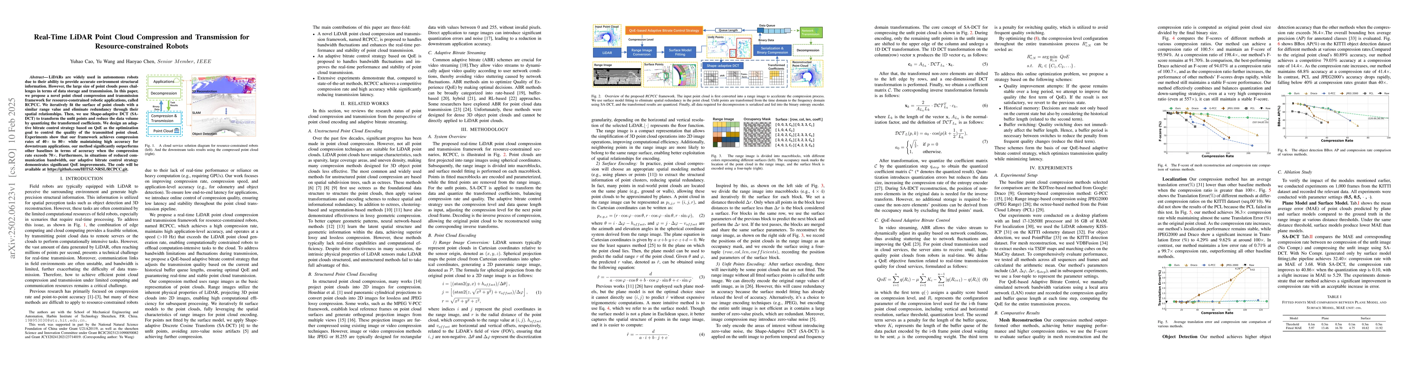
LiDARs are widely used in autonomous robots due to their ability to provide accurate environment structural information. However, the large size of point clouds poses challenges in terms of data storage and transmission. In this paper, we propose a novel point cloud compression and transmission framework for resource-constrained robotic applications, called RCPCC. We iteratively fit the surface of point clouds with a similar range value and eliminate redundancy through their spatial relationships. Then, we use Shape-adaptive DCT (SA-DCT) to transform the unfit points and reduce the data volume by quantizing the transformed coefficients. We design an adaptive bitrate control strategy based on QoE as the optimization goal to control the quality of the transmitted point cloud. Experiments show that our framework achieves compression rates of 40$\times$ to 80$\times$ while maintaining high accuracy for downstream applications. our method significantly outperforms other baselines in terms of accuracy when the compression rate exceeds 70$\times$. Furthermore, in situations of reduced communication bandwidth, our adaptive bitrate control strategy demonstrates significant QoE improvements. The code will be available at https://github.com/HITSZ-NRSL/RCPCC.git.

AI Key Findings

Generated Jun 11, 2025

Methodology

The proposed framework, RCPCC, converts LiDAR point clouds into range images using spherical projections, followed by surface model fitting, Shape-adaptive DCT (SA-DCT) transformation, and quantization. An adaptive bitrate control strategy based on Quality of Experience (QoE) optimizes the compression level dynamically.

Key Results

  • RCPCC achieves compression rates of 40x to 80x while maintaining high accuracy for downstream applications.
  • The method significantly outperforms other baselines in terms of accuracy when the compression rate exceeds 70x.
  • In situations of reduced communication bandwidth, the adaptive bitrate control strategy demonstrates significant QoE improvements.

Significance

This research is significant for resource-constrained robots as it enables real-time LiDAR point cloud transmission with high compression rates and minimal loss of accuracy, crucial for applications like autonomous navigation.

Technical Contribution

The novel combination of surface model fitting, SA-DCT, and an adaptive QoE-based bitrate control strategy for efficient LiDAR point cloud compression and transmission.

Novelty

RCPCC distinguishes itself by focusing on real-time performance and high accuracy for resource-constrained robots, employing SA-DCT for unfit points, and using a QoE-driven adaptive bitrate control strategy, which are not common in existing LiDAR compression frameworks.

Limitations

  • The paper does not discuss the computational resources required for the proposed method, which could be a limitation for very low-resource devices.
  • The performance of RCPCC in highly dynamic environments with rapidly changing point cloud data is not explicitly evaluated.

Future Work

  • Investigate the computational complexity and resource requirements for deployment on even lower-end hardware.
  • Evaluate the method's robustness in highly dynamic environments with fast-moving objects.

Paper Details

PDF Preview

Download PDF

Key Terms

No key terms available for this paper.

Citation Network

Current paper (gray), citations (green), references (blue)

Current Paper
Citations
References
Click to view

No citations found for this paper.

Comments (0)

This website uses cookies to ensure you get the best experience. Learn more