Publication
Metrics
Paper Preview
Abstract
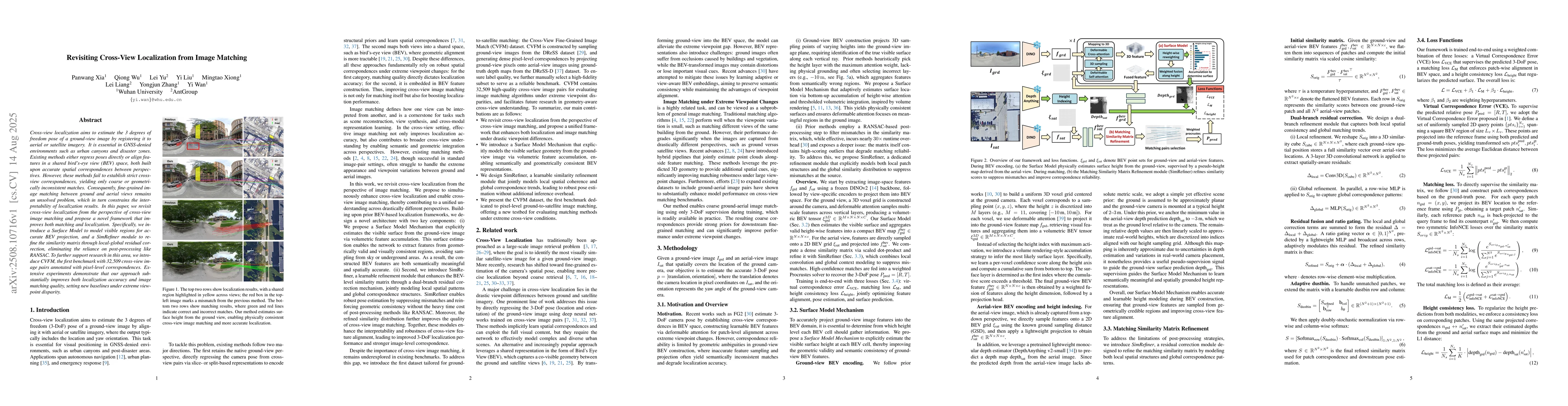
Cross-view localization aims to estimate the 3 degrees of freedom pose of a ground-view image by registering it to aerial or satellite imagery. It is essential in GNSS-denied environments such as urban canyons and disaster zones. Existing methods either regress poses directly or align features in a shared bird's-eye view (BEV) space, both built upon accurate spatial correspondences between perspectives. However, these methods fail to establish strict cross-view correspondences, yielding only coarse or geometrically inconsistent matches. Consequently, fine-grained image matching between ground and aerial views remains an unsolved problem, which in turn constrains the interpretability of localization results. In this paper, we revisit cross-view localization from the perspective of cross-view image matching and propose a novel framework that improves both matching and localization. Specifically, we introduce a Surface Model to model visible regions for accurate BEV projection, and a SimRefiner module to refine the similarity matrix through local-global residual correction, eliminating the reliance on post-processing like RANSAC. To further support research in this area, we introduce CVFM, the first benchmark with 32,509 cross-view image pairs annotated with pixel-level correspondences. Extensive experiments demonstrate that our approach substantially improves both localization accuracy and image matching quality, setting new baselines under extreme viewpoint disparity.
AI Key Findings
Get AI-generated insights about this paper's methodology, results, significance, and more — seven facets brought into focus.
Discussion 0