ArxivLens

Publication

Published: Jan 22, 2026
Categories: cs.IT

Metrics

Source: ArXiv

Quick Answers

What methodology did the authors use?

The research proposes a RIS-aided cooperative ISAC network for low-altitude airspace surveillance, modeling it as a compressive sensing (CS) imaging problem solved via the subspace pursuit (SP) algorithm. It derives the Cramér-Rao Lower Bound (CRLB) for the system and analyzes the impact of various system parameters on sensing performance through theoretical analysis and simulations. More in Methodology →

What are the key results?

ARIS provides superior performance over PRIS under the same power constraints by amplifying signals — ARIS-aided systems can achieve surveillance at low altitudes below 300 meters More in Key Results →

Why is this work significant?

This research addresses the limitations of high deployment costs and weak signals in conventional low-altitude surveillance methods, offering a promising solution for future network deployments with improved efficiency and accuracy. More in Significance →

What are the main limitations?

The analysis assumes ideal RIS characteristics and perfect channel state information (CSI) — The CRLB analysis may not fully capture real-world system complexities More in Limitations →

Paper Preview

Abstract

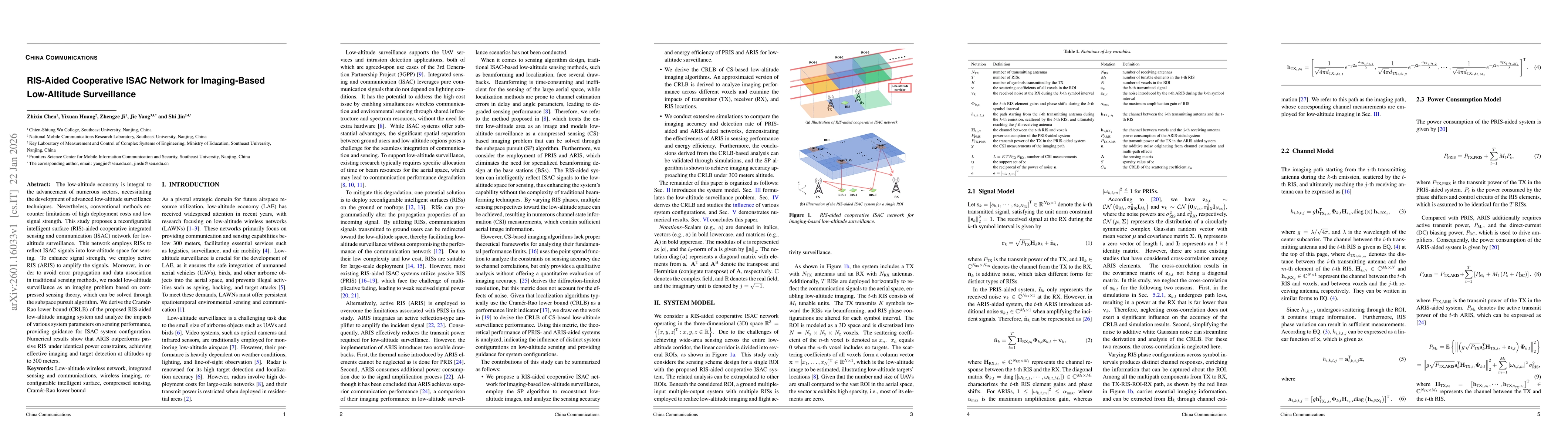
The low-altitude economy is integral to the advancement of numerous sectors, necessitating the development of advanced low-altitude surveillance techniques. Nevertheless, conventional methods encounter limitations of high deployment costs and low signal strength. This study proposes a reconfigurable intelligent surface (RIS)-aided cooperative integrated sensing and communication (ISAC) network for low-altitude surveillance. This network employs RISs to reflect ISAC signals into low-altitude space for sensing. To enhance signal strength, we employ active RIS (ARIS) to amplify the signals. Moreover, in order to avoid error propagation and data association in traditional sensing methods, we model low-altitude surveillance as an imaging problem based on compressed sensing theory, which can be solved through the subspace pursuit algorithm. We derive the Cramer-Rao lower bound (CRLB) of the proposed RIS-aided low-altitude imaging system and analyze the impacts of various system parameters on sensing performance, providing guidance for ISAC system configuration. Numerical results show that ARIS outperforms passive RIS under identical power constraints, achieving effective imaging and target detection at altitudes up to 300 meters.

Key Findings, in focus

Seven facets of this paper, analysed and brought into focus by AI.

AI-generated · verify against source Generated Jan 23, 2026
In focus · one-line synthesis

This research addresses the limitations of high deployment costs and weak signals in conventional low-altitude surveillance methods, offering a promising solution for future network deployments with improved efficiency and accuracy.

01
MethodologyHow they did it

The research proposes a RIS-aided cooperative ISAC network for low-altitude airspace surveillance, modeling it as a compressive sensing (CS) imaging problem solved via the subspace pursuit (SP) algorithm. It derives the Cramér-Rao Lower Bound (CRLB) for the system and analyzes the impact of various system parameters on sensing performance through theoretical analysis and simulations.

02
ResultsWhat they found
  • ARIS provides superior performance over PRIS under the same power constraints by amplifying signals
  • ARIS-aided systems can achieve surveillance at low altitudes below 300 meters
  • The work provides insights into system parameter design: RX should be near ROI center, TX close to RIS, and RIS spacing balances path length and imaging aperture
03
SignificanceWhy it matters

This research addresses the limitations of high deployment costs and weak signals in conventional low-altitude surveillance methods, offering a promising solution for future network deployments with improved efficiency and accuracy.

04
Technical ContributionsWhat's new technically

Derivation of CRLB for RIS-aided low-altitude imaging systems and analysis of system parameter impacts on sensing performance

05
NoveltyWhat sets it apart

Integration of RIS with ISAC for low-altitude surveillance, combined with CS-based imaging and CRLB analysis for performance evaluation

06
LimitationsWhat to be cautious about
  • The analysis assumes ideal RIS characteristics and perfect channel state information (CSI)
  • The CRLB analysis may not fully capture real-world system complexities
07
Future WorkWhere it goes next
  • Optimization of RIS deployment strategies
  • Handling of more complex non-ideal interference scenarios

Paper Details

Paper ID: 2601.16033
Comments: Accepted by China Communications
Categories:
cs.IT

How to Cite This Paper

Reference manager: RIS EndNote


Discussion 0

This website uses cookies to ensure you get the best experience. Learn more