AI Quick Summary
This paper proposes a road similarity-based method for UGV localization using BEV perception images and satellite maps, achieving high-precision positioning in GNSS-denied environments. The method integrates LiDAR-inertial odometry, BEV image generation, and particle filtering for robust localization, demonstrating stability and accuracy over a 10 km test with minimal errors.
Quick Answers
What methodology did the authors use?
The methodology involves implementing a robust LiDAR-inertial odometry system, fusing LiDAR and image data to generate a local Bird's Eye View (BEV) perception image of the UGV, projecting BEV image and satellite map into a road similarity space, and using Normalized Cross Correlation (NCC) to assess matching scores. A particle filter then estimates the probability distribution of the vehicle's pose. More in Methodology →
What are the key results?
The localization system demonstrated stability without divergence over a 10 km test, achieving an average lateral error of 0.89 meters and a planar Euclidean error of 3.41 meters. — Accurate and stable global localization was maintained even under nighttime conditions, validating robustness and adaptability. More in Key Results →
Why is this work significant?
This research is important for addressing the challenge of autonomous Unmanned Ground Vehicle (UGV) localization in GNSS-denied off-road environments, providing a high-precision positioning method that combines BEV perception images with satellite maps. More in Significance →
What are the main limitations?
The paper does not discuss limitations explicitly, but potential limitations could include dependency on high-quality LiDAR and image data, computational resources for real-time processing, and the assumption of road-like environments. More in Limitations →
Abstract
To address the challenge of autonomous UGV localization in GNSS-denied off-road environments,this study proposes a matching-based localization method 
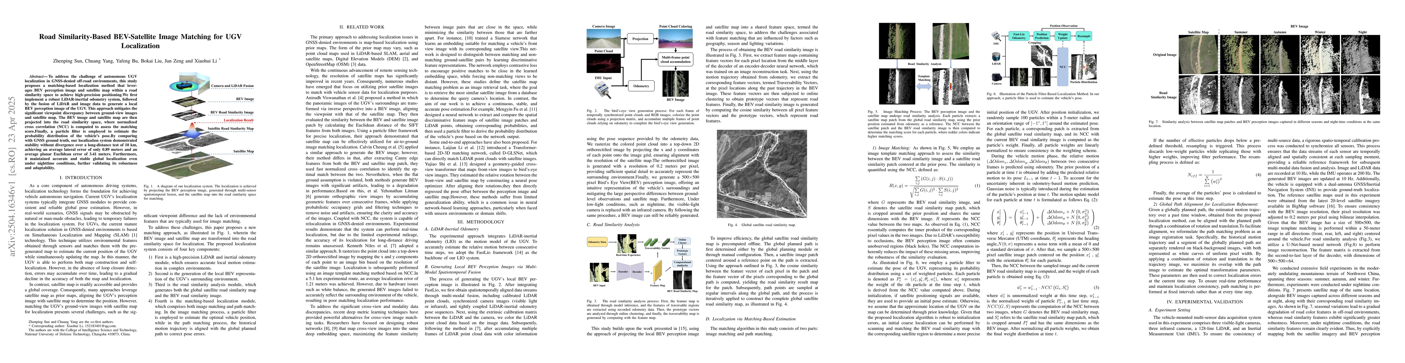
that leverages BEV perception image and satellite map within a road similarity space to achieve high-precision positioning.We first implement a robust LiDAR-inertial odometry system, followed by the fusion of LiDAR and image data to generate a local BEV perception image of the UGV. This approach mitigates the significant viewpoint discrepancy between ground-view images and satellite map. The BEV image and satellite map are then projected into the road similarity space, where normalized cross correlation (NCC) is computed to assess the matching score.Finally, a particle filter is employed to estimate the probability distribution of the vehicle's pose.By comparing with GNSS ground truth, our localization system demonstrated stability without divergence over a long-distance test of 10 km, achieving an average lateral error of only 0.89 meters and an average planar Euclidean error of 3.41 meters. Furthermore, it maintained accurate and stable global localization even under nighttime conditions, further validating its robustness and adaptability.
AI Key Findings
Generated Jun 09, 2025
Methodology — What approach did the authors take?
The methodology involves implementing a robust LiDAR-inertial odometry system, fusing LiDAR and image data to generate a local Bird's Eye View (BEV) perception image of the UGV, projecting BEV image and satellite map into a road similarity space, and using Normalized Cross Correlation (NCC) to assess matching scores. A particle filter then estimates the probability distribution of the vehicle's pose.
Key Results — What are the main findings?
- The localization system demonstrated stability without divergence over a 10 km test, achieving an average lateral error of 0.89 meters and a planar Euclidean error of 3.41 meters.
- Accurate and stable global localization was maintained even under nighttime conditions, validating robustness and adaptability.
Significance — Why does this research matter?
This research is important for addressing the challenge of autonomous Unmanned Ground Vehicle (UGV) localization in GNSS-denied off-road environments, providing a high-precision positioning method that combines BEV perception images with satellite maps.
Technical Contribution — What is the technical contribution?
The main technical contribution is the road similarity-based BEV-satellite image matching method for UGV localization, which effectively mitigates viewpoint discrepancies and provides stable, high-precision positioning in GNSS-denied environments.
Novelty — What is new about this work?
This work stands out by introducing a novel approach that combines BEV perception images with satellite maps in a road similarity space, enabling accurate localization in off-road settings without GNSS.
Limitations — What are the limitations of this study?
- The paper does not discuss limitations explicitly, but potential limitations could include dependency on high-quality LiDAR and image data, computational resources for real-time processing, and the assumption of road-like environments.
Future Work — What did the authors propose for future work?
- Future work could focus on improving the method's performance in diverse terrains, reducing computational demands, and integrating more sensor modalities for enhanced robustness.
- Exploration of machine learning techniques for more accurate road similarity assessment and localization refinement could be beneficial.
Paper Details
How to Cite This Paper
@article{liu2025road,
title = {Road Similarity-Based BEV-Satellite Image Matching for UGV Localization},
author = {Liu, Bokai and Yang, Chuang and Zeng, Jun and others},
year = {2025},
eprint = {2504.16346},
archivePrefix = {arXiv},
primaryClass = {cs.RO},
}
Liu, B., Yang, C., Zeng, J., Li, X., Bu, Y., & Sun, Z. (2025). Road Similarity-Based BEV-Satellite Image Matching for UGV Localization. arXiv. https://arxiv.org/abs/2504.16346
Liu, Bokai, et al. "Road Similarity-Based BEV-Satellite Image Matching for UGV Localization." arXiv, 2025, arxiv.org/abs/2504.16346.
PDF Preview
Citation Network
Current paper (gray), citations (green), references (blue)
Display is limited for performance on very large graphs.
Similar Papers
Found 4 papersBEV-Patch-PF: Particle Filtering with BEV-Aerial Feature Matching for Off-Road Geo-Localization
Dongmyeong Lee, Jesse Quattrociocchi, Christian Ellis et al.
Satellite Image Based Cross-view Localization for Autonomous Vehicle
Shan Wang, Yanhao Zhang, Ankit Vora et al.
No citations found for this paper.
Comments (0)