ArxivLens

Publication

Published: Apr 09, 2025
Updated: Apr 21, 2025
Categories: cs.CV

Metrics

Source: ArXiv

AI Quick Summary

A new dataset called S-EO is introduced for geometry-aware shadow detection in remote sensing applications, featuring 702 high-resolution images of the USA, along with ground-truth data and a shadow mask, to advance 3D reconstruction.

Quick Answers

What is "S-EO: A Large-Scale Dataset for Geometry-Aware Shadow Detection in Remote Sensing Applications" about?

A new dataset called S-EO is introduced for geometry-aware shadow detection in remote sensing applications, featuring 702 high-resolution images of the USA, along with ground-truth data and a shadow mask, to advance 3D reconstruction.

What methodology did the authors use?

The S-EO dataset was created using WorldView-3 imagery, panchromatic and pansharpened RGB images, RPC models, and LiDAR-derived DSMs. Shadow masks were automatically generated using a shadow simulation algorithm that casts shadows over DSMs based on sun position and projects them onto images using RPCs. More in Methodology →

What are the key results?

The S-EO dataset comprises 702 georeferenced tiles across the USA, providing approximately 20,000 images with associated shadow, vegetation, and RPC masks. — A shadow detection network was trained on the S-EO dataset using U-Net and FSDNet architectures, demonstrating improved shadow detection performance with data augmentation and color correction techniques. More in Key Results →

Why is this work significant?

The S-EO dataset serves as a large-scale resource for training shadow detection models in remote sensing imagery, with applications in 3D reconstruction and improved NeRF-based geometry estimation. More in Significance →

What are the main limitations?

DSMs and satellite images may be captured at different times, leading to discrepancies and potential missing or phantom shadows. — Transient objects and seasonal vegetation changes can introduce spurious shadow artifacts that are not always fully removed by post-processing or vegetation masks. More in Limitations →

Paper Preview

Abstract

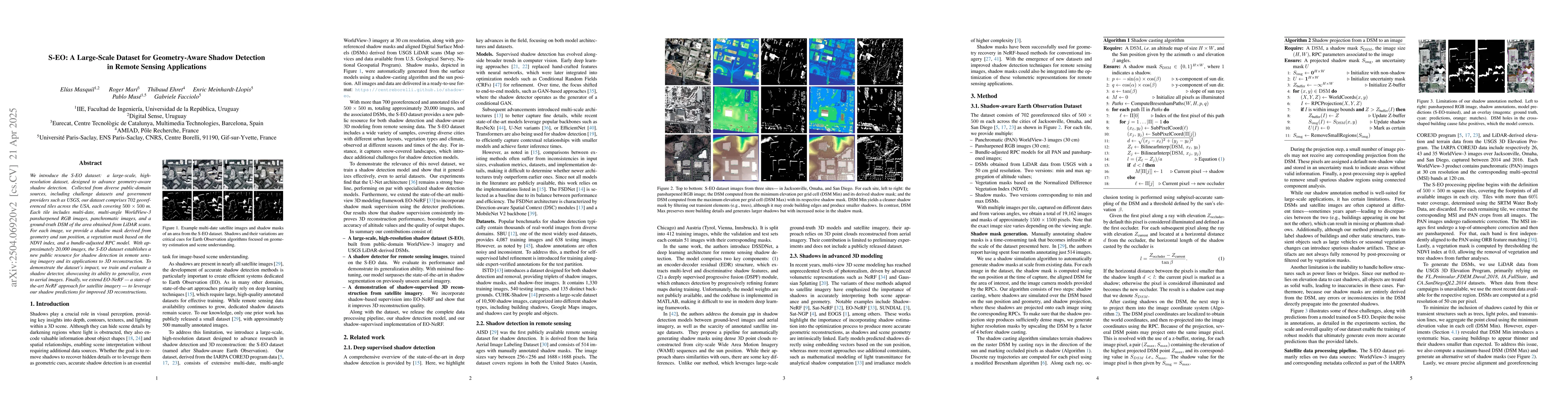
We introduce the S-EO dataset: a large-scale, high-resolution dataset, designed to advance geometry-aware shadow detection. Collected from diverse public-domain sources, including challenge datasets and government providers such as USGS, our dataset comprises 702 georeferenced tiles across the USA, each covering 500x500 m. Each tile includes multi-date, multi-angle WorldView-3 pansharpened RGB images, panchromatic images, and a ground-truth DSM of the area obtained from LiDAR scans. For each image, we provide a shadow mask derived from geometry and sun position, a vegetation mask based on the NDVI index, and a bundle-adjusted RPC model. With approximately 20,000 images, the S-EO dataset establishes a new public resource for shadow detection in remote sensing imagery and its applications to 3D reconstruction. To demonstrate the dataset's impact, we train and evaluate a shadow detector, showcasing its ability to generalize, even to aerial images. Finally, we extend EO-NeRF - a state-of-the-art NeRF approach for satellite imagery - to leverage our shadow predictions for improved 3D reconstructions.

Key Findings, in focus

Seven facets of this paper, analysed and brought into focus by AI.

AI-generated · verify against source Generated Jun 10, 2025
In focus · one-line synthesis

The S-EO dataset serves as a large-scale resource for training shadow detection models in remote sensing imagery, with applications in 3D reconstruction and improved NeRF-based geometry estimation.

01
MethodologyHow they did it

The S-EO dataset was created using WorldView-3 imagery, panchromatic and pansharpened RGB images, RPC models, and LiDAR-derived DSMs. Shadow masks were automatically generated using a shadow simulation algorithm that casts shadows over DSMs based on sun position and projects them onto images using RPCs.

02
ResultsWhat they found
  • The S-EO dataset comprises 702 georeferenced tiles across the USA, providing approximately 20,000 images with associated shadow, vegetation, and RPC masks.
  • A shadow detection network was trained on the S-EO dataset using U-Net and FSDNet architectures, demonstrating improved shadow detection performance with data augmentation and color correction techniques.
  • The shadow detector generalized well to unseen aerial imagery using the AISD dataset after fine-tuning with a small subset of AISD training data.
  • Extending EO-NeRF with shadow supervision from the S-EO dataset's predicted shadow masks resulted in improved geometry estimation and sharper, less noisy outputs compared to the original EO-NeRF method.
03
SignificanceWhy it matters

The S-EO dataset serves as a large-scale resource for training shadow detection models in remote sensing imagery, with applications in 3D reconstruction and improved NeRF-based geometry estimation.

04
Technical ContributionsWhat's new technically

The automatic shadow mask generation algorithm using sun position and DSM geometry, along with the fine-tuning of EO-NeRF for shadow supervision.

05
NoveltyWhat sets it apart

The S-EO dataset is unique in its large-scale, high-resolution, and geometry-aware nature, providing a comprehensive resource for shadow detection in remote sensing applications.

06
LimitationsWhat to be cautious about
  • DSMs and satellite images may be captured at different times, leading to discrepancies and potential missing or phantom shadows.
  • Transient objects and seasonal vegetation changes can introduce spurious shadow artifacts that are not always fully removed by post-processing or vegetation masks.
  • The method struggles with hollow structures like power lines or bridges, treating all objects as solid walls.
07
Future WorkWhere it goes next
  • Addressing the limitations of the shadow annotation method to handle transient objects, seasonal changes, and hollow structures more accurately.
  • Exploring the integration of the shadow-based supervision approach with other 3D modeling methods beyond EO-NeRF.

Impact

46
References

Paper Details

Paper ID: 2504.06920
Comments: Accepted at Earthvision 2025 (CVPR Workshop)
Categories:
cs.CV

How to Cite This Paper

Reference manager: RIS EndNote

Citation Network

Current paper (gray), citations (green), references (blue)

Display is limited for performance on very large graphs.

Current Paper
Citations
References
Click to view


Discussion 0

This website uses cookies to ensure you get the best experience. Learn more