SeeFar: Satellite Agnostic Multi-Resolution Dataset for Geospatial Foundation Models
Publication
Metrics
AI Quick Summary
SeeFar is a satellite-agnostic multi-resolution dataset combining public and commercial satellite images to train geospatial foundation models, addressing the barriers of high cost and limited availability of commercial data. It standardizes and aligns diverse satellite data to enhance interoperability and accessibility for researchers and policymakers.
Paper Preview
Abstract
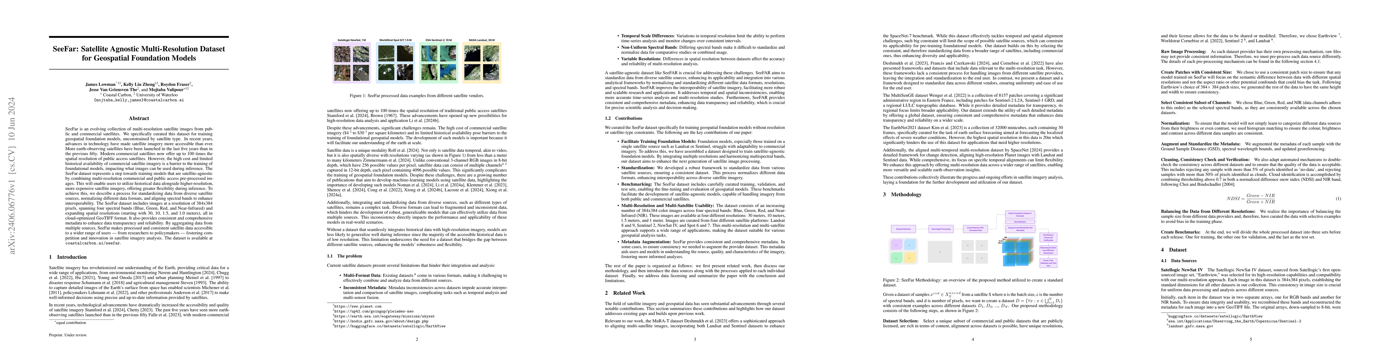
SeeFar is an evolving collection of multi-resolution satellite images from public and commercial satellites. We specifically curated this dataset for training geospatial foundation models, unconstrained by satellite type. In recent years, advances in technology have made satellite imagery more accessible than ever. More earth-observing satellites have been launched in the last five years than in the previous fifty. Modern commercial satellites now offer up to 100 times the spatial resolution of public access satellites. However, the high cost and limited historical availability of commercial satellite imagery is a barrier to the training of foundational models, impacting what images can be used during inference. The SeeFar dataset represents a step towards training models that are satellite-agnostic by combining multi-resolution commercial and public access pre-processed images. This will enable users to utilize historical data alongside higher-resolution, more expensive satellite imagery, offering greater flexibility during inference. To achieve this, we describe a process for standardizing data from diverse satellite sources, normalizing different data formats, and aligning spectral bands to enhance interoperability. The SeeFar dataset includes images at a resolution of 384x384 pixels, spanning four spectral bands (Blue, Green, Red, and Near-Infrared) and expanding spatial resolutions (starting with 30, 10, 1.5, and 1.0 meters), all in cloud-optimized GeoTIFF format. It also provides consistent and comprehensive metadata to enhance data transparency and reliability. By aggregating data from multiple sources, SeeFar makes processed and consistent satellite data accessible to a wider range of users - from researchers to policymakers - fostering competition and innovation in satellite imagery analysis. The dataset is available at \url{coastalcarbon.ai/seefar}.
AI Key Findings
Get AI-generated insights about this paper's methodology, results, significance, and more — seven facets brought into focus.
Impact
Paper Details
Authors
PDF Preview
Key Terms
Citation Network
Current paper (gray), citations (green), references (blue)
Display is limited for performance on very large graphs.
Discussion 0