ArxivLens

Publication

Published: May 24, 2024
Categories: cs.CV

Metrics

Source: ArXiv

AI Quick Summary

This research proposes using Geospatial Foundation Models like Prithvi for multi-spectral remote sensing image retrieval, achieving high accuracy and generalization without fine-tuning. Prithvi outperforms RGB-based models and employs compressed embeddings for efficient retrieval while maintaining accuracy.

Quick Answers

What is "Multi-Spectral Remote Sensing Image Retrieval Using Geospatial Foundation Models" about?

This research proposes using Geospatial Foundation Models like Prithvi for multi-spectral remote sensing image retrieval, achieving high accuracy and generalization without fine-tuning. Prithvi outperforms RGB-based models and employs compressed embeddings for efficient retrieval while maintaining accuracy.

What methodology did the authors use?

The research proposes using Geospatial Foundation Models (GeoFMs) like Prithvi for multi-spectral remote sensing image retrieval. These models encode multi-spectral satellite data and generalize without further fine-tuning, utilizing two introduced datasets: BigEarthNet-43 and ForestNet-12. More in Methodology →

What are the key results?

Prithvi-100M achieves a mean Average Precision (mAP) of 97.62% on BigEarthNet-43 and 44.51% on ForestNet-12, outperforming RGB-based models. — Compression methods with binarized embeddings balance retrieval speed and accuracy, matching the speed of shorter hash codes while maintaining the same accuracy as floating-point embeddings but with a 32-fold compression. More in Key Results →

Why is this work significant?

This work demonstrates the applicability of GeoFMs for image retrieval in remote sensing, providing strong baselines for more holistic evaluations in the future. More in Significance →

What are the main limitations?

The study is limited to specific GeoFM models and datasets, which may not generalize to all remote sensing scenarios. — The effect of different satellite data sources and multi-spectral channels on performance was not extensively explored. More in Limitations →

Paper Preview

Abstract

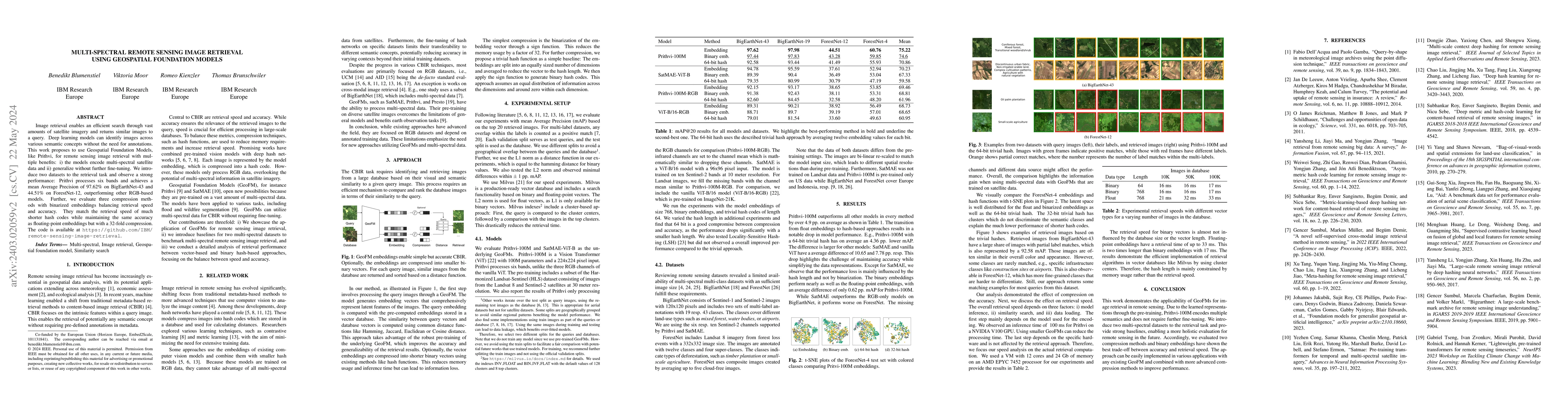
Image retrieval enables an efficient search through vast amounts of satellite imagery and returns similar images to a query. Deep learning models can identify images across various semantic concepts without the need for annotations. This work proposes to use Geospatial Foundation Models, like Prithvi, for remote sensing image retrieval with multiple benefits: i) the models encode multi-spectral satellite data and ii) generalize without further fine-tuning. We introduce two datasets to the retrieval task and observe a strong performance: Prithvi processes six bands and achieves a mean Average Precision of 97.62% on BigEarthNet-43 and 44.51% on ForestNet-12, outperforming other RGB-based models. Further, we evaluate three compression methods with binarized embeddings balancing retrieval speed and accuracy. They match the retrieval speed of much shorter hash codes while maintaining the same accuracy as floating-point embeddings but with a 32-fold compression. The code is available at https://github.com/IBM/remote-sensing-image-retrieval.

Key Findings, in focus

Seven facets of this paper, analysed and brought into focus by AI.

AI-generated · verify against source Generated Sep 07, 2025
In focus · one-line synthesis

This work demonstrates the applicability of GeoFMs for image retrieval in remote sensing, providing strong baselines for more holistic evaluations in the future.

01
MethodologyHow they did it

The research proposes using Geospatial Foundation Models (GeoFMs) like Prithvi for multi-spectral remote sensing image retrieval. These models encode multi-spectral satellite data and generalize without further fine-tuning, utilizing two introduced datasets: BigEarthNet-43 and ForestNet-12.

02
ResultsWhat they found
  • Prithvi-100M achieves a mean Average Precision (mAP) of 97.62% on BigEarthNet-43 and 44.51% on ForestNet-12, outperforming RGB-based models.
  • Compression methods with binarized embeddings balance retrieval speed and accuracy, matching the speed of shorter hash codes while maintaining the same accuracy as floating-point embeddings but with a 32-fold compression.
  • Prithvi-100M outperforms all other models by over 4.9 pp on average in various methods.
03
SignificanceWhy it matters

This work demonstrates the applicability of GeoFMs for image retrieval in remote sensing, providing strong baselines for more holistic evaluations in the future.

04
Technical ContributionsWhat's new technically

The research introduces two multi-spectral datasets for retrieval tasks and evaluates compression methods for efficient retrieval using GeoFMs.

05
NoveltyWhat sets it apart

The approach leverages pre-trained GeoFMs to encode multi-spectral data, improving retrieval accuracy and generalizability without further fine-tuning, which differentiates it from existing RGB-focused methods.

06
LimitationsWhat to be cautious about
  • The study is limited to specific GeoFM models and datasets, which may not generalize to all remote sensing scenarios.
  • The effect of different satellite data sources and multi-spectral channels on performance was not extensively explored.
07
Future WorkWhere it goes next
  • Explore the use of GeoFMs with other remote sensing datasets and satellite data sources.
  • Investigate the impact of varying spatial resolutions and data augmentation techniques on retrieval performance.

Impact

25
References

Paper Details

Paper ID: 2403.02059
License: http://creativecommons.org/licenses/by-nc-sa/4.0/
Comments: Proceedings of the IEEE International Geoscience and Remote Sensing Symposium (IGARSS)
Categories:
cs.CV

How to Cite This Paper

Reference manager: RIS EndNote

Key Terms

retrieval (0.308)
remote sensing (0.230)
embeddings (0.198)
remote (0.197)
satellite (0.193)
compression (0.193)
sensing (0.176)
image (0.169)

Citation Network

Current paper (gray), citations (green), references (blue)

Display is limited for performance on very large graphs.

Current Paper
Citations
References
Click to view


Discussion 0

This website uses cookies to ensure you get the best experience. Learn more