Quick Summary:

Researchers developed SeG-SR, a new method for super-resolving remote sensing images using semantic knowledge, achieving state-of-the-art performance on two datasets.

Summary

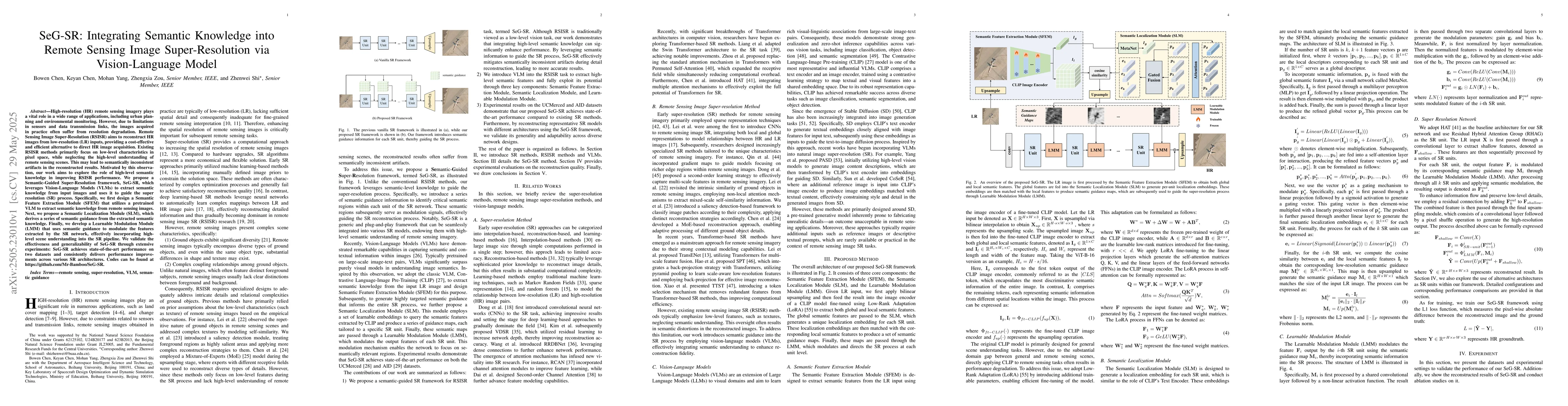
High-resolution (HR) remote sensing imagery plays a vital role in a wide range of applications, including urban planning and environmental monitoring. However, due to limitations in sensors and data transmission links, the images acquired in practice often suffer from resolution degradation. Remote Sensing Image Super-Resolution (RSISR) aims to reconstruct HR images from low-resolution (LR) inputs, providing a cost-effective and efficient alternative to direct HR image acquisition. Existing RSISR methods primarily focus on low-level characteristics in pixel space, while neglecting the high-level understanding of remote sensing scenes. This may lead to semantically inconsistent artifacts in the reconstructed results. Motivated by this observation, our work aims to explore the role of high-level semantic knowledge in improving RSISR performance. We propose a Semantic-Guided Super-Resolution framework, SeG-SR, which leverages Vision-Language Models (VLMs) to extract semantic knowledge from input images and uses it to guide the super resolution (SR) process. Specifically, we first design a Semantic Feature Extraction Module (SFEM) that utilizes a pretrained VLM to extract semantic knowledge from remote sensing images. Next, we propose a Semantic Localization Module (SLM), which derives a series of semantic guidance from the extracted semantic knowledge. Finally, we develop a Learnable Modulation Module (LMM) that uses semantic guidance to modulate the features extracted by the SR network, effectively incorporating high-level scene understanding into the SR pipeline. We validate the effectiveness and generalizability of SeG-SR through extensive experiments: SeG-SR achieves state-of-the-art performance on two datasets and consistently delivers performance improvements across various SR architectures. Codes can be found at https://github.com/Mr-Bamboo/SeG-SR.

AI Key Findings

Generated Jun 05, 2025

Methodology

The paper proposes SeG-SR, a Semantic-Guided Super-Resolution framework for Remote Sensing Image Super-Resolution (RSISR). It integrates Vision-Language Models (VLMs) to extract semantic knowledge and guide the super-resolution process, comprising Semantic Feature Extraction Module (SFEM), Semantic Localization Module (SLM), and Learnable Modulation Module (LMM).

Key Results

  • SeG-SR outperforms existing state-of-the-art methods on UCMerced and AID datasets in both ×2 and ×4 super-resolution tasks.
  • On UCMerced, SeG-SR achieves the best PSNR and SSIM scores in ×4 SR, surpassing the baseline HAT by more than 0.2 dB.
  • On AID, SeG-SR also achieves the best performance for ×4 SR in both evaluation metrics.
  • SeG-SR demonstrates robust adaptability across diverse remote sensing scene types, excelling in at least one evaluation metric for 18 out of 20 scene categories in UCMerced.
  • Visual comparisons show that SeG-SR produces the most visually accurate and detailed reconstructions compared to other methods on both UCMerced and AID datasets.

Significance

This research is significant as it introduces high-level semantic understanding into RSISR, addressing the limitation of existing methods that primarily focus on low-level pixel characteristics.

Technical Contribution

The main technical contribution is the Semantic-Guided Super-Resolution (SeG-SR) framework, which incorporates VLMs to extract semantic knowledge and guide the super-resolution process, enhancing the accuracy and fidelity of RSISR.

Novelty

The novelty lies in integrating vision-language models for semantic guidance in RSISR, which is different from traditional methods focusing solely on pixel-level characteristics.

Limitations

  • The study was conducted on two specific datasets (UCMerced and AID), so generalizability to other types of remote sensing data remains to be explored.
  • The computational cost of using VLMs might be a limitation for real-time applications.

Future Work

  • Explore the applicability of SeG-SR on other remote sensing datasets and scenarios.
  • Investigate methods to reduce computational complexity for real-time or resource-constrained applications.

Paper Details

PDF Preview

Download PDF

Key Terms

No key terms available for this paper.

No citations found for this paper.

Comments (0)

This website uses cookies to ensure you get the best experience. Learn more