Quick Summary:

This paper presents a novel SLAM approach that uses road elements for enhanced localization accuracy in outdoor environments with rolling-shutter cameras and low-precision INS, achieving significant improvements over existing methods.

Summary

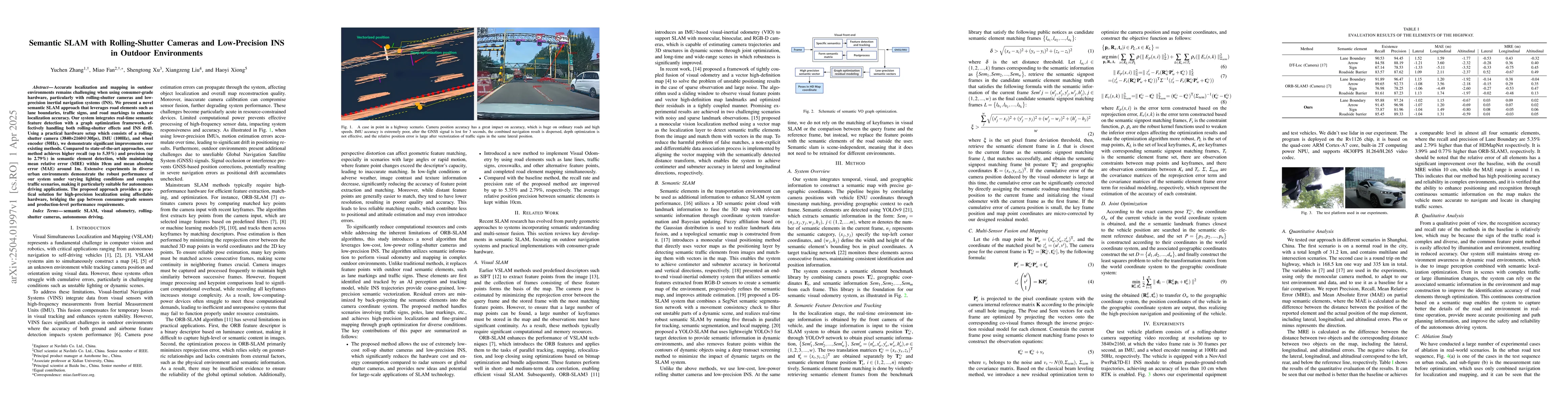
Accurate localization and mapping in outdoor environments remains challenging when using consumer-grade hardware, particularly with rolling-shutter cameras and low-precision inertial navigation systems (INS). We present a novel semantic SLAM approach that leverages road elements such as lane boundaries, traffic signs, and road markings to enhance localization accuracy. Our system integrates real-time semantic feature detection with a graph optimization framework, effectively handling both rolling-shutter effects and INS drift. Using a practical hardware setup which consists of a rolling-shutter camera (3840*2160@30fps), IMU (100Hz), and wheel encoder (50Hz), we demonstrate significant improvements over existing methods. Compared to state-of-the-art approaches, our method achieves higher recall (up to 5.35\%) and precision (up to 2.79\%) in semantic element detection, while maintaining mean relative error (MRE) within 10cm and mean absolute error (MAE) around 1m. Extensive experiments in diverse urban environments demonstrate the robust performance of our system under varying lighting conditions and complex traffic scenarios, making it particularly suitable for autonomous driving applications. The proposed approach provides a practical solution for high-precision localization using affordable hardware, bridging the gap between consumer-grade sensors and production-level performance requirements.

AI Key Findings

Generated Jun 10, 2025

Methodology

The research presents a semantic SLAM approach using rolling-shutter cameras and low-precision INS, integrating real-time semantic feature detection with a graph optimization framework to handle rolling-shutter effects and INS drift.

Key Results

  • Significant improvements in semantic element detection (up to 5.35% recall and 2.79% precision)
  • Mean relative error (MRE) maintained within 10cm and mean absolute error (MAE) around 1m
  • Demonstrated robust performance in diverse urban environments with varying lighting and traffic conditions

Significance

This work provides a practical solution for high-precision localization using affordable hardware, bridging the gap between consumer-grade sensors and production-level performance requirements, particularly beneficial for autonomous driving applications.

Technical Contribution

The novel algorithm utilizes semantic information to perform visual odometry and mapping in complex outdoor environments, replacing traditional feature points with outdoor road semantic elements.

Novelty

The approach leverages low-cost, low-power rolling-shutter cameras and low-precision INS, offering new ideas for large-scale SLAM applications and introducing a method for visual odometry using road elements without relying on keyframe matching or comparison between query and reference frames.

Limitations

  • The study did not use LiDAR in experiments
  • Performance was evaluated only with monocular camera methods as a baseline

Future Work

  • Extending the system to handle more dynamic environments
  • Improving real-time performance on embedded platforms

Paper Details

PDF Preview

Download PDF

Key Terms

No key terms available for this paper.

Citation Network

Current paper (gray), citations (green), references (blue)

Current Paper
Citations
References
Click to view

No citations found for this paper.

Comments (0)

This website uses cookies to ensure you get the best experience. Learn more