Semi-Supervised Contrastive Learning for Remote Sensing: Identifying Ancient Urbanization in the South Central Andes
Publication
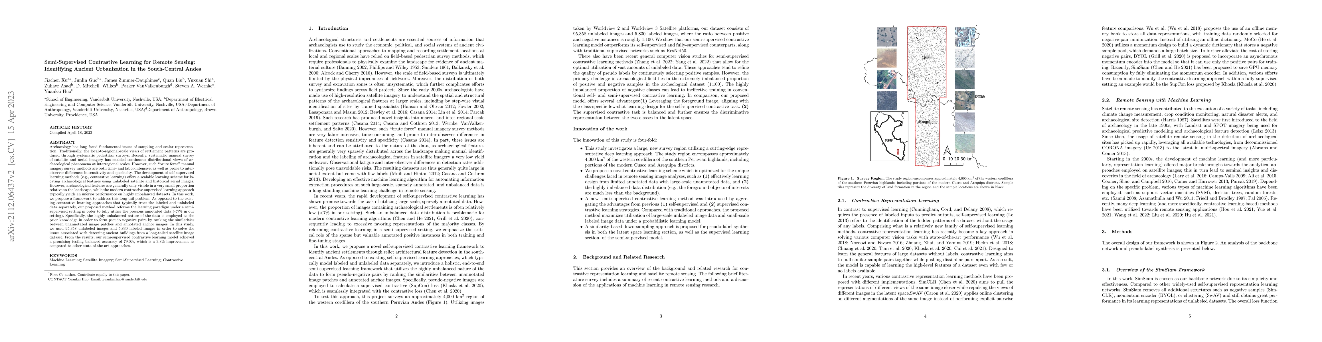
Metrics
AI Quick Summary
This paper proposes a semi-supervised contrastive learning framework to address the long-tail problem in detecting ancient urbanization features from satellite imagery in the South Central Andes. The method leverages a small amount of labeled data to improve performance on highly imbalanced datasets, achieving a 79.0% balanced accuracy, outperforming existing approaches by 3.8%.
Paper Preview
Abstract
Archaeology has long faced fundamental issues of sampling and scalar representation. Traditionally, the local-to-regional-scale views of settlement patterns are produced through systematic pedestrian surveys. Recently, systematic manual survey of satellite and aerial imagery has enabled continuous distributional views of archaeological phenomena at interregional scales. However, such 'brute force' manual imagery survey methods are both time- and labor-intensive, as well as prone to inter-observer differences in sensitivity and specificity. The development of self-supervised learning methods offers a scalable learning scheme for locating archaeological features using unlabeled satellite and historical aerial images. However, archaeological features are generally only visible in a very small proportion relative to the landscape, while the modern contrastive-supervised learning approach typically yields an inferior performance on highly imbalanced datasets. In this work, we propose a framework to address this long-tail problem. As opposed to the existing contrastive learning approaches that treat the labelled and unlabeled data separately, our proposed method reforms the learning paradigm under a semi-supervised setting in order to utilize the precious annotated data (<7% in our setting). Specifically, the highly unbalanced nature of the data is employed as the prior knowledge in order to form pseudo negative pairs by ranking the similarities between unannotated image patches and annotated anchor images. In this study, we used 95,358 unlabeled images and 5,830 labelled images in order to solve the issues associated with detecting ancient buildings from a long-tailed satellite image dataset. From the results, our semi-supervised contrastive learning model achieved a promising testing balanced accuracy of 79.0%, which is a 3.8% improvement as compared to other state-of-the-art approaches.
AI Key Findings
Get AI-generated insights about this paper's methodology, results, significance, and more — seven facets brought into focus.
Impact
Paper Details
Authors
PDF Preview
Key Terms
Citation Network
Current paper (gray), citations (green), references (blue)
Display is limited for performance on very large graphs.
Discussion 0