Publication
Metrics
AI Quick Summary
This paper proposes Sky-GVINS, a GNSS-Visual-Inertial system that uses sky segmentation to improve GNSS measurement reliability and localization accuracy in urban canyons by rejecting Non-Line-Of-Sight signals. The Otsu algorithm is found to be the most effective for sky region detection.
Paper Preview
Abstract
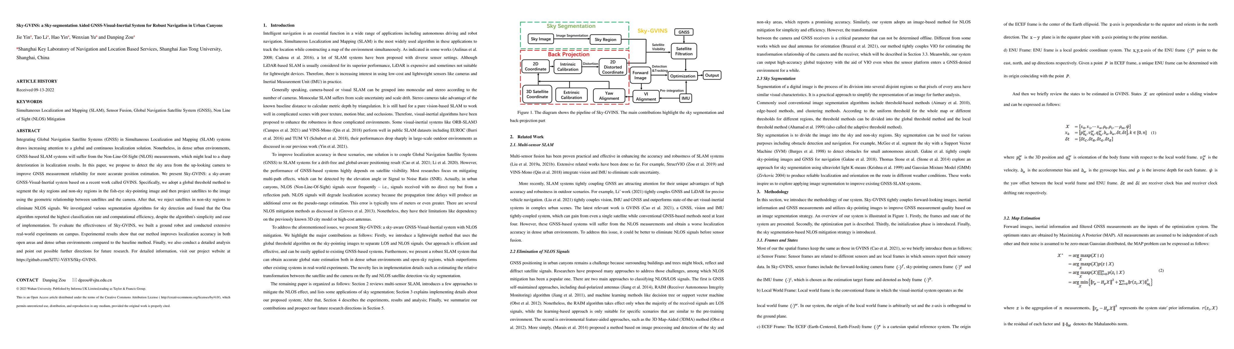
Integrating Global Navigation Satellite Systems (GNSS) in Simultaneous Localization and Mapping (SLAM) systems draws increasing attention to a global and continuous localization solution. Nonetheless, in dense urban environments, GNSS-based SLAM systems will suffer from the Non-Line-Of-Sight (NLOS) measurements, which might lead to a sharp deterioration in localization results. In this paper, we propose to detect the sky area from the up-looking camera to improve GNSS measurement reliability for more accurate position estimation. We present Sky-GVINS: a sky-aware GNSS-Visual-Inertial system based on a recent work called GVINS. Specifically, we adopt a global threshold method to segment the sky regions and non-sky regions in the fish-eye sky-pointing image and then project satellites to the image using the geometric relationship between satellites and the camera. After that, we reject satellites in non-sky regions to eliminate NLOS signals. We investigated various segmentation algorithms for sky detection and found that the Otsu algorithm reported the highest classification rate and computational efficiency, despite the algorithm's simplicity and ease of implementation. To evaluate the effectiveness of Sky-GVINS, we built a ground robot and conducted extensive real-world experiments on campus. Experimental results show that our method improves localization accuracy in both open areas and dense urban environments compared to the baseline method. Finally, we also conduct a detailed analysis and point out possible further directions for future research. For detailed information, visit our project website at https://github.com/SJTU-ViSYS/Sky-GVINS.
AI Key Findings
Get AI-generated insights about this paper's methodology, results, significance, and more — seven facets brought into focus.
Impact
Paper Details
Authors
PDF Preview
Key Terms
Citation Network
Current paper (gray), citations (green), references (blue)
Display is limited for performance on very large graphs.
Discussion 0