Publication
Metrics
Quick Actions
AI Quick Summary
Researchers developed a method to estimate distance to trees on landscape photos using skyline variations in semantic segmentation, achieving a 0.47 R2 score in regression analysis.
Quick Answers
What is "Skyline variations allow estimating distance to trees on landscape photos using semantic segmentation" about?
Researchers developed a method to estimate distance to trees on landscape photos using skyline variations in semantic segmentation, achieving a 0.47 R2 score in regression analysis.
What methodology did the authors use?
The methodology involves using semantic segmentation with DeepLabV3+ trained on the COCO dataset to extract skyline objects from LUCAS landscape photos. Skyline height in pixels (skyline signal) is analyzed using three metrics (NSL, sample variance, absolute deviation) to investigate relationships with distance to skyline objects. Regression analysis is performed against 475 ortho-photo based distance measurements. More in Methodology →
What are the key results?
Three skyline variation metrics (NSL, sample variance, absolute deviation) show functional relationships with distance for trees. — Best R2 score of 0.47 achieved for trees, indicating significant components of sample variance variations can be explained by a power law model depending on distance. More in Key Results →
Why is this work significant?
This research demonstrates the potential of skyline variation metrics for inferring distance-related information from landscape photos, which can be useful for estimating landscape complexity and openness. More in Significance →
What are the main limitations?
The study is limited by potential errors in camera location, reference object location, measurement process limitations, human operator errors, and orthorectification errors. — Larger distances may lead to lack of detail in the signal, saturating the model. More in Limitations →
Abstract
Approximate distance estimation can be used to determine fundamental landscape properties including complexity and openness. We show that variations 
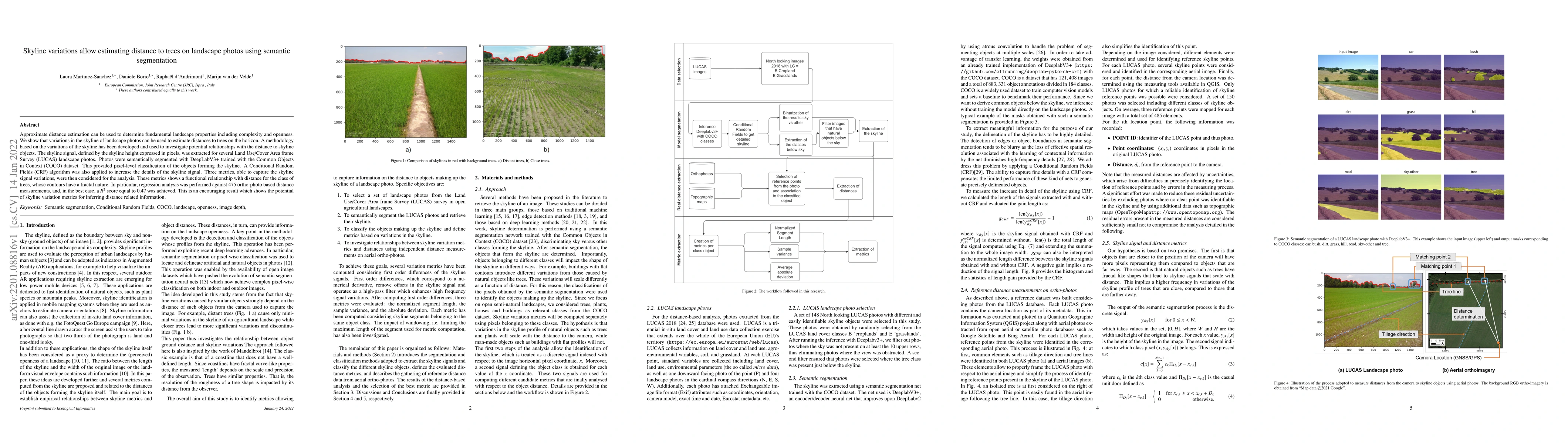
in the skyline of landscape photos can be used to estimate distances to trees on the horizon. A methodology based on the variations of the skyline has been developed and used to investigate potential relationships with the distance to skyline objects. The skyline signal, defined by the skyline height expressed in pixels, was extracted for several Land Use/Cover Area frame Survey (LUCAS) landscape photos. Photos were semantically segmented with DeepLabV3+ trained with the Common Objects in Context (COCO) dataset. This provided pixel-level classification of the objects forming the skyline. A Conditional Random Fields (CRF) algorithm was also applied to increase the details of the skyline signal. Three metrics, able to capture the skyline signal variations, were then considered for the analysis. These metrics shows a functional relationship with distance for the class of trees, whose contours have a fractal nature. In particular, regression analysis was performed against 475 ortho-photo based distance measurements, and, in the best case, a R2 score equal to 0.47 was achieved. This is an encouraging result which shows the potential of skyline variation metrics for inferring distance related information.
AI Key Findings
Generated Sep 02, 2025
Methodology — What approach did the authors take?
The methodology involves using semantic segmentation with DeepLabV3+ trained on the COCO dataset to extract skyline objects from LUCAS landscape photos. Skyline height in pixels (skyline signal) is analyzed using three metrics (NSL, sample variance, absolute deviation) to investigate relationships with distance to skyline objects. Regression analysis is performed against 475 ortho-photo based distance measurements.
Key Results — What are the main findings?
- Three skyline variation metrics (NSL, sample variance, absolute deviation) show functional relationships with distance for trees.
- Best R2 score of 0.47 achieved for trees, indicating significant components of sample variance variations can be explained by a power law model depending on distance.
- CRF application significantly improves skyline signal detail and length by an average of 105.47%.
Significance — Why does this research matter?
This research demonstrates the potential of skyline variation metrics for inferring distance-related information from landscape photos, which can be useful for estimating landscape complexity and openness.
Technical Contribution — What is the technical contribution?
The paper presents a novel method for estimating distances to trees on landscape photos using semantic segmentation and skyline variations, backed by regression analysis.
Novelty — What is new about this work?
This work differs from existing research by exploiting the fractal-like visual appearance of natural objects like trees and their diminishing visual detail with distance, combined with semantic segmentation for object identification and profile extraction.
Limitations — What are the limitations of this study?
- The study is limited by potential errors in camera location, reference object location, measurement process limitations, human operator errors, and orthorectification errors.
- Larger distances may lead to lack of detail in the signal, saturating the model.
Future Work — What did the authors propose for future work?
- Future work will involve precise field measurements using tape meters and GNSS receivers for distant objects.
- The metric developed could be applied to detect woody vegetation in photos and support applications like monitoring woody vegetation regrowth.
Paper Details
How to Cite This Paper
@article{borio2022skyline,
title = {Skyline variations allow estimating distance to trees on landscape
photos using semantic segmentation},
author = {Borio, Daniele and Martinez-Sanchez, Laura and Velde, Marijn van der and others},
year = {2022},
eprint = {2201.08816},
archivePrefix = {arXiv},
primaryClass = {cs.CV},
}
Borio, D., Martinez-Sanchez, L., Velde, M., & d'Andrimont, R. (2022). Skyline variations allow estimating distance to trees on landscape
photos using semantic segmentation. arXiv. https://arxiv.org/abs/2201.08816
Borio, Daniele, et al. "Skyline variations allow estimating distance to trees on landscape
photos using semantic segmentation." arXiv, 2022, arxiv.org/abs/2201.08816.
PDF Preview
Key Terms
Citation Network
Current paper (gray), citations (green), references (blue)
Display is limited for performance on very large graphs.
Similar Papers
Found 4 papersGeneralized Referring Expression Segmentation on Aerial Photos
Luís Marnoto, Alexandre Bernardino, Bruno Martins
Semantic Segmentation on 3D Point Clouds with High Density Variations
Ryan Faulkner, Luke Haub, Simon Ratcliffe et al.
From Pixels to Damage Severity: Estimating Earthquake Impacts Using Semantic Segmentation of Social Media Images
Danrong Zhang, Huili Huang, N. Simrill Smith et al.
Distance Guided Channel Weighting for Semantic Segmentation
Xuanyi Liu, Shiping Zhu, Lanyun Zhu et al.
| Title | Authors | Year | Actions |
|---|
Comments (0)