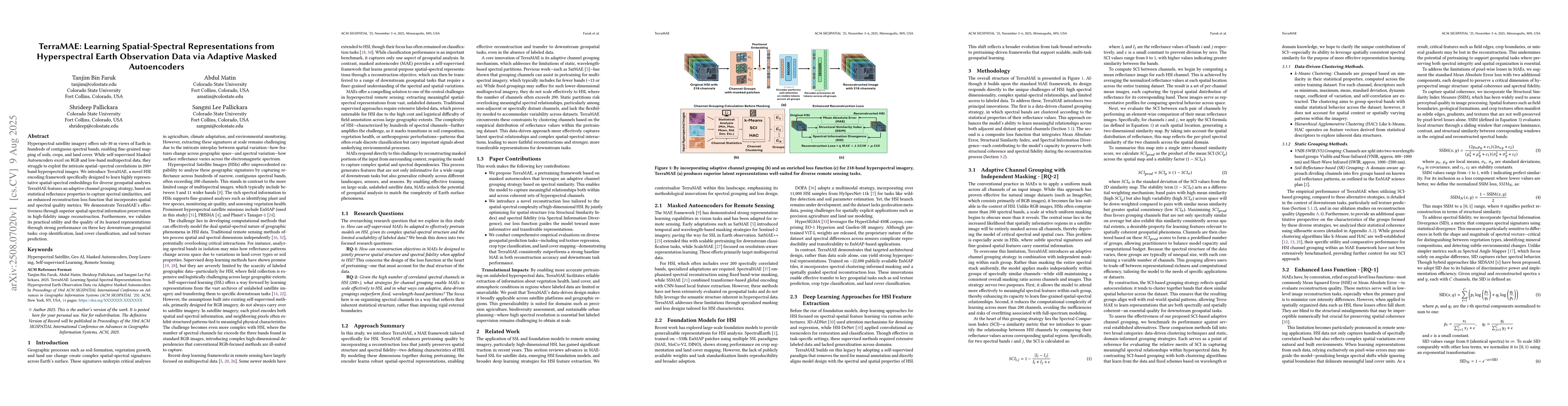
Hyperspectral satellite imagery offers sub-30 m views of Earth in hundreds of contiguous spectral bands, enabling fine-grained mapping of soils, crops, and land cover. While self-supervised Masked Autoencoders excel on RGB and low-band multispectral data, they struggle to exploit the intricate spatial-spectral correlations in 200+ band hyperspectral images. We introduce TerraMAE, a novel HSI encoding framework specifically designed to learn highly representative spatial-spectral embeddings for diverse geospatial analyses. TerraMAE features an adaptive channel grouping strategy, based on statistical reflectance properties to capture spectral similarities, and an enhanced reconstruction loss function that incorporates spatial and spectral quality metrics. We demonstrate TerraMAE's effectiveness through superior spatial-spectral information preservation in high-fidelity image reconstruction. Furthermore, we validate its practical utility and the quality of its learned representations through strong performance on three key downstream geospatial tasks: crop identification, land cover classification, and soil texture prediction.
Generated Aug 14, 2025
The paper introduces TerraMAE, a self-supervised model designed to learn generalizable spatial-spectral representations for downstream geospatial tasks from hyperspectral imagery. TerraMAE uses adaptive channel grouping based on spatial-spectral coherence and an enhanced loss function integrating pixel-level error with measures of structural similarity and spectral divergence.
This research is significant as it develops a self-supervised model, TerraMAE, that learns generalizable spatial-spectral representations from hyperspectral imagery, which are crucial for various geospatial tasks. The model's ability to adaptively group channels based on spatial-spectral coherence and its enhanced loss function, which considers both local spatial patterns and inter-band spectral relationships, sets it apart from existing methods.
The primary technical contribution of this work is the development of TerraMAE, a self-supervised model that learns spatial-spectral representations from hyperspectral imagery using adaptive channel grouping and an enhanced loss function.
TerraMAE's novelty lies in its adaptive channel grouping strategy based on spatial-spectral coherence and its enhanced loss function that integrates pixel-level error with measures of structural similarity and spectral divergence, enabling it to outperform existing methods on various geospatial tasks.
Comments (0)