Quick Summary:

This paper proposes a GeoQA Portal that leverages a multi-agent Large Language Model framework to enable natural language interaction with geospatial data, simplifying complex GIS functionalities for non-expert users. The system uses specialized agents for subtask management, semantic search, and transparent task plans to enhance data accessibility and usability.

Summary

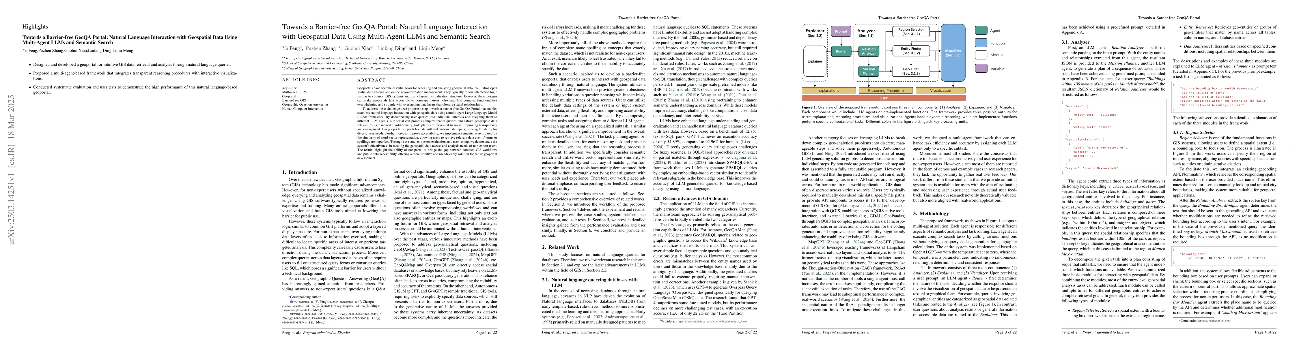
A Barrier-Free GeoQA Portal: Enhancing Geospatial Data Accessibility with a Multi-Agent LLM Framework Geoportals are vital for accessing and analyzing geospatial data, promoting open spatial data sharing and online geo-information management. Designed with GIS-like interaction and layered visualization, they often challenge non-expert users with complex functionalities and overlapping layers that obscure spatial relationships. We propose a GeoQA Portal using a multi-agent Large Language Model framework for seamless natural language interaction with geospatial data. Complex queries are broken into subtasks handled by specialized agents, retrieving relevant geographic data efficiently. Task plans are shown to users, boosting transparency. The portal supports default and custom data inputs for flexibility. Semantic search via word vector similarity aids data retrieval despite imperfect terms. Case studies, evaluations, and user tests confirm its effectiveness for non-experts, bridging GIS complexity and public access, and offering an intuitive solution for future geoportals.

AI Key Findings

Generated Jun 10, 2025

Methodology

The research proposes a GeoQA Portal using a multi-agent LLM framework for natural language interaction with geospatial data, breaking complex queries into subtasks handled by specialized agents and using semantic search for efficient data retrieval.

Key Results

  • The proposed GeoQA Portal effectively bridges GIS complexity and public access, offering an intuitive solution for future geoportals.
  • Case studies, evaluations, and user tests confirm its effectiveness for non-experts.
  • The system outperforms baseline methods in accuracy for tasks of varying complexity.
  • The multi-agent LLM design enhances precision and retrieval comprehensiveness compared to vector search-based methods.
  • The framework demonstrates robustness and effectiveness in handling increasingly complex queries.

Significance

This research is significant as it enhances accessibility to geospatial data for non-expert users, simplifying interaction with GIS systems, and providing a scalable solution for future geoportals.

Technical Contribution

The paper introduces a novel multi-agent LLM framework for natural language interaction with geospatial data, enhancing accessibility and usability of geoportals.

Novelty

This work differs from existing research by focusing on a multi-agent LLM approach for geospatial data interaction, providing a more intuitive and efficient solution for non-expert users.

Limitations

  • The system's performance may be affected by the quality and completeness of the underlying geospatial datasets.
  • There is a need for continuous model training and updating to maintain accuracy and relevance.

Future Work

  • Explore integration with real-time data sources for dynamic geospatial analysis.
  • Investigate methods to further reduce token usage and improve efficiency in LLM-based agents.

Paper Details

PDF Preview

Download PDF

Key Terms

No key terms available for this paper.

Citation Network

Current paper (gray), citations (green), references (blue)

Current Paper
Citations
References
Click to view

No citations found for this paper.

Comments (0)

This website uses cookies to ensure you get the best experience. Learn more