Publication

Published: Oct 11, 2025
Categories: cs.CV

Metrics

Source: ArXiv

Quick Actions

View PDF

Quick Answers

What methodology did the authors use?

The study proposes a novel framework using a vision foundation model to track the spatiotemporal evolution of landslide scars by reconstructing discrete optical remote sensing images into continuous video sequences for video segmentation. More in Methodology →

What are the key results?

The framework achieved high accuracy with average IoU, precision, and recall values of 0.919, 0.963, and 0.952 for the Baige landslide case. — The framework successfully captured pre-failure progressive deformation and post-failure evolution, including failure precursors and long-term stability monitoring. More in Key Results →

Why is this work significant?

This research provides a robust method for continuous landslide monitoring, enabling early warning systems and long-term stability assessments, which is critical for disaster mitigation and infrastructure protection. More in Significance →

What are the main limitations?

Current vision foundation models lack specialized geoscience feature representations leading to suboptimal performance. — The framework requires careful data preprocessing to handle issues like cloud cover and vegetation interference. More in Limitations →

Paper Preview

Abstract

Tracking the spatiotemporal evolution of large-scale landslide scars is critical for understanding the evolution mechanisms and failure precursors, enabling effective early-warning. However, most existing studies have focused on single-phase or pre- and post-failure dual-phase landslide identification. Although these approaches delineate post-failure landslide boundaries, it is challenging to track the spatiotemporal evolution of landslide scars. To 
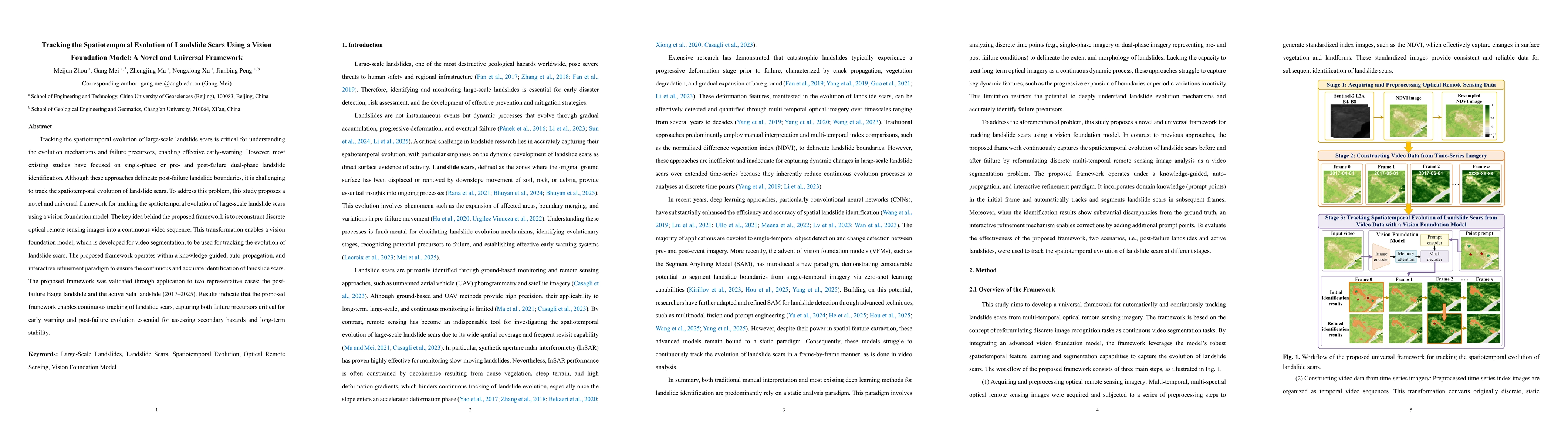
address this problem, this study proposes a novel and universal framework for tracking the spatiotemporal evolution of large-scale landslide scars using a vision foundation model. The key idea behind the proposed framework is to reconstruct discrete optical remote sensing images into a continuous video sequence. This transformation enables a vision foundation model, which is developed for video segmentation, to be used for tracking the evolution of landslide scars. The proposed framework operates within a knowledge-guided, auto-propagation, and interactive refinement paradigm to ensure the continuous and accurate identification of landslide scars. The proposed framework was validated through application to two representative cases: the post-failure Baige landslide and the active Sela landslide (2017-2025). Results indicate that the proposed framework enables continuous tracking of landslide scars, capturing both failure precursors critical for early warning and post-failure evolution essential for assessing secondary hazards and long-term stability.

AI Key Findings

Generated Nov 01, 2025

Methodology — What approach did the authors take?

The study proposes a novel framework using a vision foundation model to track the spatiotemporal evolution of landslide scars by reconstructing discrete optical remote sensing images into continuous video sequences for video segmentation.

Key Results — What are the main findings?

  • The framework achieved high accuracy with average IoU, precision, and recall values of 0.919, 0.963, and 0.952 for the Baige landslide case.
  • The framework successfully captured pre-failure progressive deformation and post-failure evolution, including failure precursors and long-term stability monitoring.
  • It demonstrated effectiveness in tracking active landslides like the Sela landslide with IoU, precision, and recall values of 0.774, 0.877, and 0.873 respectively.

Significance — Why does this research matter?

This research provides a robust method for continuous landslide monitoring, enabling early warning systems and long-term stability assessments, which is critical for disaster mitigation and infrastructure protection.

Technical Contribution — What is the technical contribution?

Developed a knowledge-guided, auto-propagation, and interactive refinement paradigm for continuous landslide scar tracking using vision foundation models.

Novelty — What is new about this work?

The framework uniquely reconstructs discrete remote sensing images into continuous video sequences for video segmentation, enabling continuous tracking of landslide scars with minimal manual intervention.

Limitations — What are the limitations of this study?

  • Current vision foundation models lack specialized geoscience feature representations leading to suboptimal performance.
  • The framework requires careful data preprocessing to handle issues like cloud cover and vegetation interference.

Future Work — What did the authors propose for future work?

  • Integrate with multi-source data like InSAR and LiDAR to create multimodal videos for better accuracy.
  • Explore parameter-efficient fine-tuning methods like LoRA for domain-specific adaptation with limited datasets.

Paper Details

Paper ID: 2510.10084
Categories:
cs.CV

How to Cite This Paper

BibTeX
@article{mei2025tracking,
  title         = {Tracking the Spatiotemporal Evolution of Landslide Scars Using a Vision
  Foundation Model: A Novel and Universal Framework},
  author        = {Mei, Gang and Peng, Jianbing and Zhou, Meijun and others},
  year          = {2025},
  eprint        = {2510.10084},
  archivePrefix = {arXiv},
  primaryClass  = {cs.CV},
}
APA 7
Mei, G., Peng, J., Zhou, M., Xu, N., & Ma, Z. (2025). Tracking the Spatiotemporal Evolution of Landslide Scars Using a Vision
  Foundation Model: A Novel and Universal Framework. arXiv. https://arxiv.org/abs/2510.10084
MLA 9
Mei, Gang, et al. "Tracking the Spatiotemporal Evolution of Landslide Scars Using a Vision
  Foundation Model: A Novel and Universal Framework." arXiv, 2025, arxiv.org/abs/2510.10084.

Comments (0)

This website uses cookies to ensure you get the best experience. Learn more