This study integrates machine learning, specifically transformer-based models, into urban aerial image analysis for identifying infrastructure surfaces related to cars and pedestrians. It presents a workflow for generating geospatial datasets from diverse sources, including WMS/WMTS links, vectorial cartography, and OpenStreetMap (OSM) overpass-turbo requests, enabling the creation of semantic segmentation datasets without manual labeling.
Publication
Metrics
AI Quick Summary
This study employs machine learning, specifically transformer-based models, to analyze historical trends in urban infrastructure surfaces in Madrid and Vienna using aerial imagery. The research demonstrates effective temporal trend analysis in car and pedestrian infrastructure without manual labeling.
Quick Answers
What is "Transport-Related Surface Detection with Machine Learning: Analyzing Temporal Trends in Madrid and Vienna" about?
This study employs machine learning, specifically transformer-based models, to analyze historical trends in urban infrastructure surfaces in Madrid and Vienna using aerial imagery. The research demonstrates effective temporal trend analysis in car and pedestrian infrastructure without manual labeling.
What methodology did the authors use?
This study integrates machine learning, specifically transformer-based models, into urban aerial image analysis for identifying infrastructure surfaces related to cars and pedestrians. It presents a workflow for generating geospatial datasets from diverse sources, including WMS/WMTS links, vectorial cartography, and OpenStreetMap (OSM) overpass-turbo requests, enabling the creation of semantic segmentation datasets without manual labeling. More in Methodology →
What are the key results?
Transformer-based models demonstrated good accuracy in detecting car and pedestrian surfaces in Madrid and Vienna. — Temporal trend analysis successfully identified changes in infrastructure for pedestrians and cars across different city areas using historical aerial images. More in Key Results →
Why is this work significant?
This research offers a cost-effective method for municipal governments to gather valuable data on urban infrastructure development and changes over time, facilitating informed urban planning and policy decisions. More in Significance →
What are the main limitations?
Ground truth data inaccuracies and incomplete data, particularly for parking spaces in both Madrid and Vienna datasets. — Differences in image resolution (10 cm/pix for Madrid vs. 15 cm/pix for Vienna) affecting model performance. More in Limitations →
Abstract
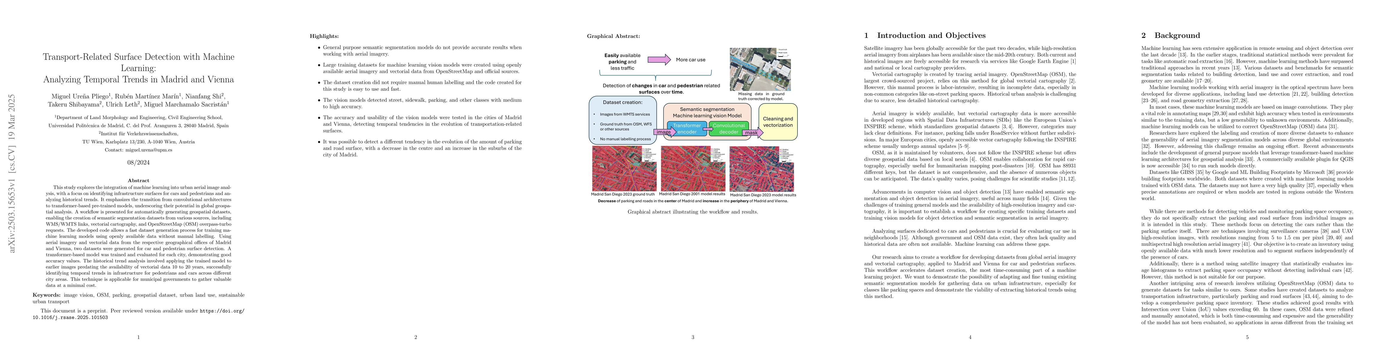
This study explores the integration of machine learning into urban aerial image analysis, with a focus on identifying infrastructure surfaces for cars and pedestrians and analyzing historical trends. It emphasizes the transition from convolutional architectures to transformer-based pre-trained models, underscoring their potential in global geospatial analysis. A workflow is presented for automatically generating geospatial datasets, enabling the creation of semantic segmentation datasets from various sources, including WMS/WMTS links, vectorial cartography, and OpenStreetMap (OSM) overpass-turbo requests. The developed code allows a fast dataset generation process for training machine learning models using openly available data without manual labelling. Using aerial imagery and vectorial data from the respective geographical offices of Madrid and Vienna, two datasets were generated for car and pedestrian surface detection. A transformer-based model was trained and evaluated for each city, demonstrating good accuracy values. The historical trend analysis involved applying the trained model to earlier images predating the availability of vectorial data 10 to 20 years, successfully identifying temporal trends in infrastructure for pedestrians and cars across different city areas. This technique is applicable for municipal governments to gather valuable data at a minimal cost.
Key Findings, in focus
Seven facets of this paper, analysed and brought into focus by AI.
This research offers a cost-effective method for municipal governments to gather valuable data on urban infrastructure development and changes over time, facilitating informed urban planning and policy decisions.
- Transformer-based models demonstrated good accuracy in detecting car and pedestrian surfaces in Madrid and Vienna.
- Temporal trend analysis successfully identified changes in infrastructure for pedestrians and cars across different city areas using historical aerial images.
This research offers a cost-effective method for municipal governments to gather valuable data on urban infrastructure development and changes over time, facilitating informed urban planning and policy decisions.
The development of a fast and adaptable dataset generation process using openly available data, along with the application of transformer-based models for urban aerial image analysis.
This work stands out by employing transformer-based models, which outperform convolutional architectures in global geospatial analysis, and by automating the generation of geospatial datasets for machine learning model training.
- Ground truth data inaccuracies and incomplete data, particularly for parking spaces in both Madrid and Vienna datasets.
- Differences in image resolution (10 cm/pix for Madrid vs. 15 cm/pix for Vienna) affecting model performance.
- Explore semi-supervised methods to correct errors within training datasets.
- Investigate the use of advanced deep learning techniques for improved accuracy in less common tasks or diverse environments.
Impact
Authors
PDF Preview
Citation Network
Current paper (gray), citations (green), references (blue)
Display is limited for performance on very large graphs.
Discussion 0