Turin3D: Evaluating Adaptation Strategies under Label Scarcity in Urban LiDAR Segmentation with Semi-Supervised Techniques

Source: ArXiv

AI Quick Summary

A new LiDAR dataset, Turin3D, is introduced for evaluating point cloud semantic segmentation techniques under label scarcity, offering a valuable resource for self-supervised learning approaches.

Share: Share on X LinkedIn

Summary

3D semantic segmentation plays a critical role in urban modelling, enabling detailed understanding and mapping of city environments. In this paper, we 
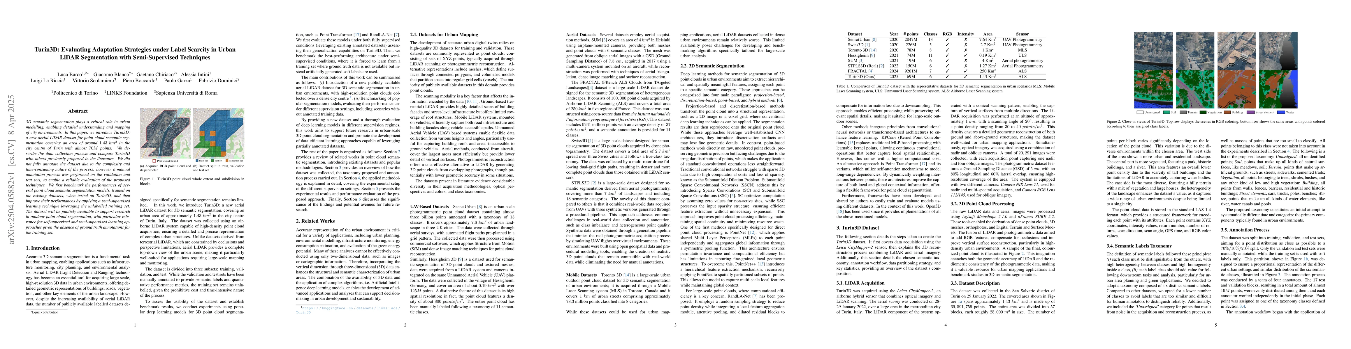
introduce Turin3D: a new aerial LiDAR dataset for point cloud semantic segmentation covering an area of around 1.43 km2 in the city centre of Turin with almost 70M points. We describe the data collection process and compare Turin3D with others previously proposed in the literature. We did not fully annotate the dataset due to the complexity and time-consuming nature of the process; however, a manual annotation process was performed on the validation and test sets, to enable a reliable evaluation of the proposed techniques. We first benchmark the performances of several point cloud semantic segmentation models, trained on the existing datasets, when tested on Turin3D, and then improve their performances by applying a semi-supervised learning technique leveraging the unlabelled training set. The dataset will be publicly available to support research in outdoor point cloud segmentation, with particular relevance for self-supervised and semi-supervised learning approaches given the absence of ground truth annotations for the training set.

AI Key Findings

Generated Jun 10, 2025

Methodology

This research evaluates different learning strategies for urban LiDAR segmentation, focusing on transfer learning and semi-supervised learning with pseudo-labeling to address label scarcity.

Key Results

  • Semi-supervised learning outperformed transfer learning, demonstrating the effectiveness of leveraging unlabeled target domain data through iterative pseudo-labeling.
  • RandLA-Net with augmentation achieved the best performance, showing resilience in classifying various urban elements like Vegetation, Buildings, and Street Elements.
  • Adaptive confidence thresholding strategy consistently improved performance, especially for Water classification, compared to fixed thresholding which led to the exclusion of low-confidence classes.

Significance

This work highlights the potential of data-efficient learning strategies in large-scale urban point cloud analysis, reducing reliance on extensive manual labeling.

Technical Contribution

The paper introduces Turin3D, a new aerial LiDAR dataset for urban semantic segmentation, and evaluates different learning strategies to address label scarcity.

Novelty

Turin3D offers a valuable benchmark for evaluating point cloud segmentation models under real-world conditions, with a balanced class taxonomy and a diverse urban landscape acquired with high-precision aerial LiDAR sensors.

Limitations

  • The study was limited by the manual annotation of only the validation and test sets, with the training set using soft labels only.
  • The performance could be further improved with a more extensive annotation effort on the training set for a fully supervised benchmark.

Future Work

  • Investigate the application of more recent deep learning architectures for point cloud segmentation.
  • Explore domain adaptation techniques specifically designed for point cloud segmentation to enhance model generalization to unseen urban environments.

Paper Details

PDF Preview

Download PDF

Citation Network

Current paper (gray), citations (green), references (blue)

Display is limited for performance on very large graphs.

Current Paper
Citations
References
Click to view

No citations found for this paper.

Comments (0)

This website uses cookies to ensure you get the best experience. Learn more