Summary
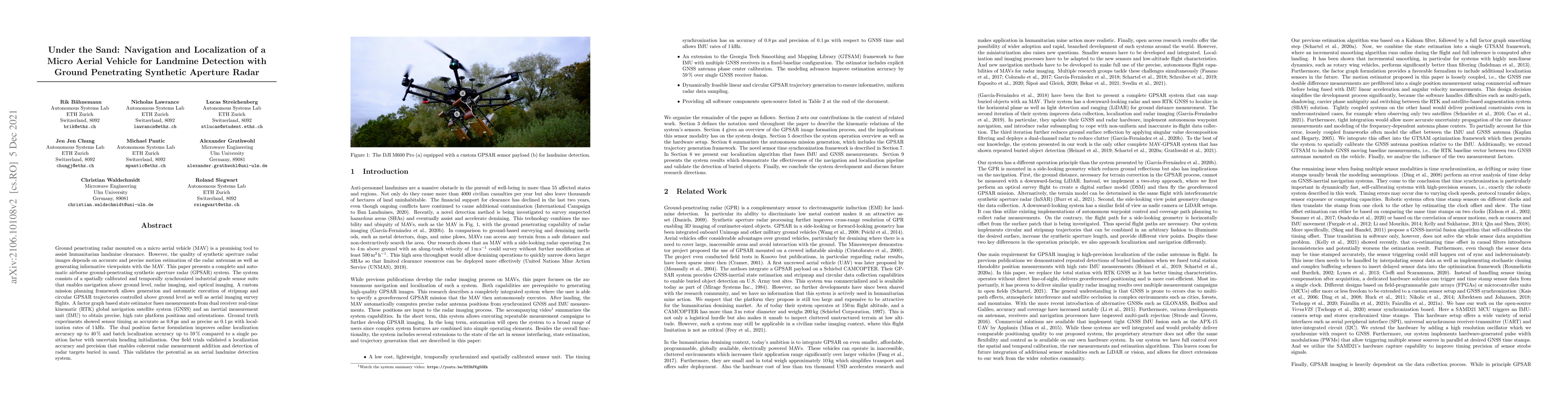
Ground penetrating radar mounted on micro aerial vehicle (MAV) is a promising tool to assist humanitarian landmine clearance. However, the quality of synthetic aperture radar images depends on accurate and precise motion estimation of the radar antennas as well as generating informative viewpoints with the MAV. This paper presents a complete and automatic airborne ground-penetrating synthetic aperture radar (GPSAR) system. The system consists of a spatially calibrated and temporally synchronized industrial grade sensor suite that enables navigation above ground level, radar imaging, and optical imaging. A custom mission planning framework allows generation and automatic execution of stripmap and circular (GPSAR) trajectories controlled above ground level as well as aerial imaging survey flights. A factor graph based state estimator fuses measurements from dual receiver real-time kinematic (RTK) global navigation satellite system (GNSS) and inertial measurement unit (IMU) to obtain precise, high rate platform positions and orientations. Ground truth experiments showed sensor timing as accurate as 0.8 us and as precise as 0.1 us with localization rates of 1 kHz. The dual position factor formulation improves online localization accuracy up to 40% and batch localization accuracy up to 59% compared to a single position factor with uncertain heading initialization. Our field trials validated a localization accuracy and precision that enables coherent radar measurement addition and detection of radar targets buried in sand. This validates the potential as an aerial landmine detection system.
AI Key Findings
Generated Sep 03, 2025
Methodology
The research presents a complete and automatic airborne ground-penetrating synthetic aperture radar (GPSAR) system for humanitarian landmine clearance, utilizing a spatially calibrated and temporally synchronized sensor suite for navigation, radar imaging, and optical imaging.
Key Results
- Sensor timing accuracy as low as 0.8 us and precision up to 0.1 us with localization rates of 1 kHz.
- Dual position factor formulation improves online localization accuracy by 40% and batch localization accuracy by 59% compared to a single position factor with uncertain heading initialization.
- Field trials validated localization accuracy and precision that enables coherent radar measurement addition and detection of radar targets buried in sand, validating the potential as an aerial landmine detection system.
Significance
This work is significant for its potential to enhance humanitarian landmine clearance efforts by providing a precise and automatic MAV-based GPSAR system, which could lead to safer and more efficient demining operations.
Technical Contribution
The paper introduces a factor graph-based state estimator that fuses measurements from dual receiver real-time kinematic (RTK) global navigation satellite system (GNSS) and inertial measurement unit (IMU) to obtain precise, high-rate platform positions and orientations.
Novelty
The proposed system's novelty lies in its complete automation, spatially calibrated sensor suite, and the use of a factor graph-based state estimator for high-precision localization, which significantly improves upon existing methods for MAV-based ground-penetrating radar systems.
Limitations
- The study was conducted in controlled environments and further real-world testing is required to validate its performance in diverse terrains and weather conditions.
- The research did not address the miniaturization and ruggedization of the system for practical deployment on small MAVs.
Future Work
- Investigate the system's performance in various real-world scenarios and terrains.
- Explore miniaturization and ruggedization of the sensor suite for practical deployment on small MAVs.
Paper Details
PDF Preview
Key Terms
Citation Network
Current paper (gray), citations (green), references (blue)
Display is limited for performance on very large graphs.
Similar Papers
Found 4 papersSynthetic aperture radar imaging below a random rough surface
Chrysoula Tsogka, Arnold D. Kim
| Title | Authors | Year | Actions |
|---|
Comments (0)