Summary

Forecasting urban phenomena such as housing prices and public health indicators requires the effective integration of various geospatial data. Current methods primarily utilize task-specific models, while recent foundation models for spatial representations often support only limited modalities and lack multimodal fusion capabilities. To overcome these challenges, we present 
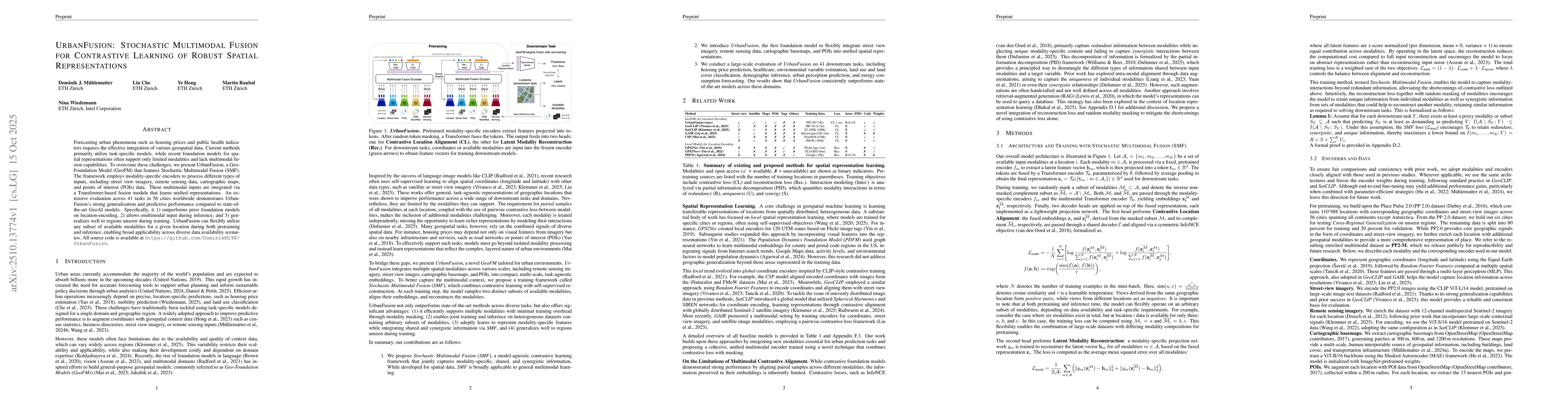
UrbanFusion, a Geo-Foundation Model (GeoFM) that features Stochastic Multimodal Fusion (SMF). The framework employs modality-specific encoders to process different types of inputs, including street view imagery, remote sensing data, cartographic maps, and points of interest (POIs) data. These multimodal inputs are integrated via a Transformer-based fusion module that learns unified representations. An extensive evaluation across 41 tasks in 56 cities worldwide demonstrates UrbanFusion's strong generalization and predictive performance compared to state-of-the-art GeoAI models. Specifically, it 1) outperforms prior foundation models on location-encoding, 2) allows multimodal input during inference, and 3) generalizes well to regions unseen during training. UrbanFusion can flexibly utilize any subset of available modalities for a given location during both pretraining and inference, enabling broad applicability across diverse data availability scenarios. All source code is available at https://github.com/DominikM198/UrbanFusion.

AI Key Findings

Generated Oct 29, 2025

Methodology

The research employs a multimodal fusion approach combining geographic coordinates, street view imagery, remote sensing data, and cartographic basemaps. It uses contrastive learning with InfoNCE loss and latent modality reconstruction to integrate diverse data sources.

Key Results

  • Achieved state-of-the-art performance in cross-regional geographic understanding
  • Demonstrated effective fusion of heterogeneous spatial data modalities
  • Enabled generalization to unseen regions through pre-trained encoders

Significance

This work advances geographic understanding by enabling comprehensive analysis of urban environments through multi-source data integration, with applications in urban planning, disaster response, and geographic information systems.

Technical Contribution

Development of a unified multimodal encoder framework with contrastive learning for spatial data fusion

Novelty

First comprehensive integration of diverse geographic data modalities with latent modality reconstruction and contrastive learning for cross-regional understanding

Limitations

  • Dependence on pre-trained models may limit adaptability to new domains
  • Performance may degrade with highly specialized or niche geographic data

Future Work

  • Exploring domain adaptation techniques for new geographic regions
  • Investigating integration with real-time data streams

Paper Details

PDF Preview

Download PDF

Comments (0)

This website uses cookies to ensure you get the best experience. Learn more