Vector-based Pedestrian Navigation in Cities

Source: ArXiv

AI Quick Summary

Researchers analyzed GPS traces to find that people deviate from shortest paths as distance increases and choose different paths when origin and destination are swapped, suggesting direction is a key factor in navigation.

Share: Share on X LinkedIn

Summary

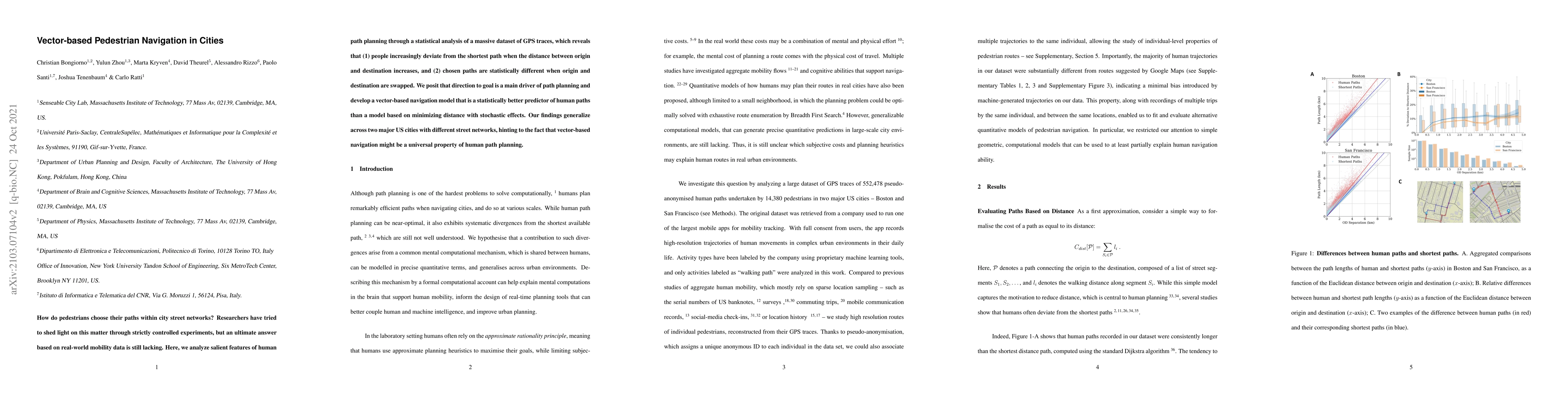
How do pedestrians choose their paths within city street networks? Researchers have tried to shed light on this matter through strictly controlled experiments, but an ultimate answer based on real-world mobility data is still lacking. Here, we analyze salient features of human path planning through a statistical analysis of a massive dataset of GPS traces, which reveals that (1) people increasingly deviate from the shortest path when the distance between origin and destination increases, and (2) chosen paths are statistically different when origin and destination are swapped. We posit that direction to goal is a main driver of path planning and develop a vector-based navigation model that is a statistically better predictor of human paths than a model based on minimizing distance with stochastic effects. Our findings generalize across two major US cities with different street networks, hinting to the fact that vector-based navigation might be a universal property of human path planning.

AI Key Findings

Generated Sep 02, 2025

Methodology

The study analyzed a large dataset of GPS traces from pedestrians in Boston and San Francisco, using statistical methods to understand human path planning in city street networks.

Key Results

  • People deviate from the shortest path as the distance between origin and destination increases.
  • Chosen paths differ significantly when origin and destination are swapped.
  • A vector-based navigation model better predicts human paths than a distance-minimizing model with stochastic effects.
  • Findings generalize across two major US cities with different street networks, suggesting vector-based navigation might be a universal property of human path planning.

Significance

This research provides insights into real-world mobility patterns, complementing laboratory studies of cognition and hinting at connections between human mobility, cognitive psychology, and neuroscience.

Technical Contribution

The paper introduces a vector-based navigation model that statistically outperforms a distance-minimizing model in predicting human paths, supported by empirical evidence from GPS traces.

Novelty

The study distinguishes itself by grounding findings in real-world mobility data, revealing behavioral trends that generalize across cities and suggesting a universal vector-based navigation property in human path planning.

Limitations

  • Lack of demographic information about users limits the applicability of findings.
  • The study couldn't account for individual differences, pre-planning, hierarchical map representations, route habits, and map learning.
  • Precise, falsifiable models restricted the study to measurable factors like direction and distance, with simplifying assumptions.

Future Work

  • Explore effects of individual differences, day of the week, weather, attractions, crowd presence, fatigue, time of day, neighborhood safety, and elevation gradient on navigation decisions.
  • Investigate mental representations of street networks, including larger streets and omitting secondary ones.
  • Develop models that account for walking speed, direction changes at traffic lights, and consistent orientation toward visual landmarks.

Paper Details

PDF Preview

Download PDF

Key Terms

street (0.272)
planning (0.261)
paths (0.251)
path (0.250)
navigation (0.240)
statistically (0.220)
human (0.208)
origin (0.179)

Citation Network

Current paper (gray), citations (green), references (blue)

Display is limited for performance on very large graphs.

Current Paper
Citations
References
Click to view
Title Authors Year Actions

Comments (0)

This website uses cookies to ensure you get the best experience. Learn more