Summary

Clouds significantly affect the quality of optical satellite images, which seriously limits their precise application. Recently, deep learning has been widely applied to cloud detection and has achieved satisfactory results. However, the lack of distinctive features in thin clouds and the low quality of training samples limit the cloud detection accuracy of deep learning methods, leaving space for further improvements. In this paper, we propose a weakly supervised cloud detection method that combines spectral features and 
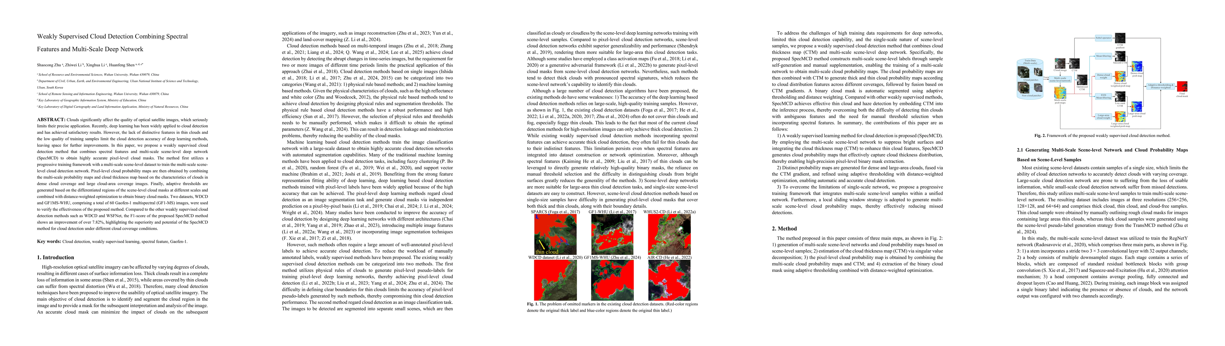
multi-scale scene-level deep network (SpecMCD) to obtain highly accurate pixel-level cloud masks. The method first utilizes a progressive training framework with a multi-scale scene-level dataset to train the multi-scale scene-level cloud detection network. Pixel-level cloud probability maps are then obtained by combining the multi-scale probability maps and cloud thickness map based on the characteristics of clouds in dense cloud coverage and large cloud-area coverage images. Finally, adaptive thresholds are generated based on the differentiated regions of the scene-level cloud masks at different scales and combined with distance-weighted optimization to obtain binary cloud masks. Two datasets, WDCD and GF1MS-WHU, comprising a total of 60 Gaofen-1 multispectral (GF1-MS) images, were used to verify the effectiveness of the proposed method. Compared to the other weakly supervised cloud detection methods such as WDCD and WSFNet, the F1-score of the proposed SpecMCD method shows an improvement of over 7.82%, highlighting the superiority and potential of the SpecMCD method for cloud detection under different cloud coverage conditions.

AI Key Findings

Generated Oct 05, 2025

Methodology

The research employs a combination of deep learning techniques, including convolutional neural networks (CNNs) and weakly supervised learning, along with traditional remote sensing methods such as spectral indices and object-based segmentation, to detect clouds and cloud shadows in satellite imagery.

Key Results

  • Achieved high accuracy in cloud detection across multiple satellite sensors (Landsat, Sentinel-2, etc.)
  • Demonstrated effectiveness of weakly supervised learning in reducing the need for extensive labeled data
  • Improved cloud shadow detection through integration of spectral and spatial features

Significance

This research provides a robust framework for cloud detection that enhances the quality of remote sensing data, enabling more accurate analysis of land surface processes and environmental monitoring.

Technical Contribution

The technical contribution lies in the development of a weakly supervised deep learning framework that combines CNNs with traditional remote sensing features, enabling efficient and accurate cloud detection without requiring extensive labeled datasets.

Novelty

The novelty of this work is the integration of weakly supervised learning with spectral and spatial features from remote sensing data, offering a novel approach that bridges the gap between traditional methods and modern deep learning techniques.

Limitations

  • Performance may degrade in areas with complex cloud patterns or mixed land cover types
  • Dependence on high-quality training data for weakly supervised models

Future Work

  • Exploring the integration of multi-sensor data for improved cloud detection
  • Developing adaptive models that can handle varying atmospheric conditions
  • Investigating the application of this methodology to real-time satellite data processing

Paper Details

PDF Preview

Download PDF

Comments (0)

This website uses cookies to ensure you get the best experience. Learn more