The latest version of the European Space Agency's Sea State Climate Change Initiative database adopts a dedicated algorithm (retracker) to reprocess two decades of satellite altimetry measurements and provide long time series of significant wave height in the global ocean. This paper describes the main characteristics of this algorithm, called WHALES, and analyzes the impact of algorithm choices on measurement physics, particularly the weighted analysis of residuals in the cost function. Moreover, the impact of WHALES on the sea state database is analyzed in terms of noise reduction and scatter index with in situ data, with a particular focus on the coastal zone, where WHALES primarily improves data quality and quantity compared to previous approaches. We found that valid data records increased by 30% at 5 km from the coast after applying the retracker discussed here.
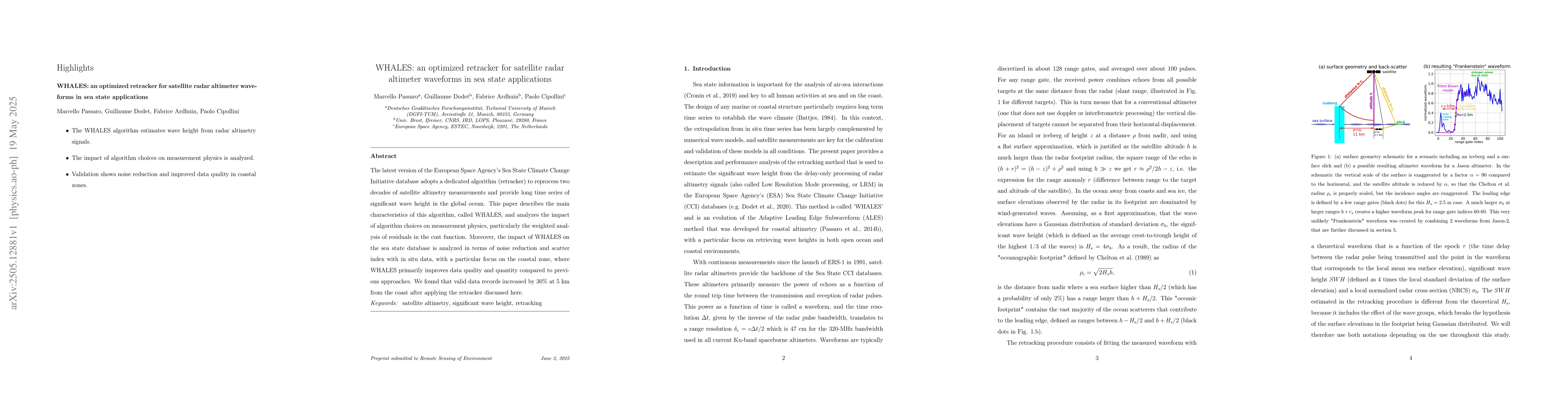
Generated Jun 08, 2025
The research describes the WHALES algorithm, an optimized retracker for satellite radar altimeter waveforms, focusing on its application in sea state measurements and its impact on the European Space Agency's Sea State Climate Change Initiative database.
This research is important for providing long-term, accurate significant wave height measurements in the global ocean, which is crucial for climate change studies and sea state applications.
The main technical contribution is the development and validation of the WHALES retracker algorithm, which optimizes waveform processing for sea state measurements from satellite radar altimetry data.
WHALES stands out due to its weighted analysis of residuals in the cost function, leading to improved noise reduction and scatter index compared to previous approaches, particularly in coastal zones.
Current paper (gray), citations (green), references (blue)
Display is limited for performance on very large graphs.
S. Vignudelli, J. Gomez-Enri, R. Abileah et al.
Ying Wang, Jarret Rock
Claire Monteleoni, Saumya Sinha, John Fasullo et al.
No citations found for this paper.
Comments (0)