ArxivLens

Publication

Published: Apr 06, 2026
Categories: cs.CV, cs.LG, cs.RO

Metrics

Source: ArXiv

Quick Answers

What methodology did the authors use?

ZeD-MAP processes UAV image streams by grouping overlapping frames into clusters, performing lightweight three‑view bundle adjustment to obtain metrically accurate camera poses and sparse 3‑D tie‑points, projecting these anchors into a representative frame, and feeding them as conditioning cues to a test‑time zero‑shot diffusion depth model (Murre) that produces dense depth maps; the resulting depth maps are fused incrementally into... More in Methodology →

What are the key results?

Achieves sub‑meter metric accuracy on a ground‑marker dataset with 0.87 m XY error and 0.12 m Z error, matching classical photogrammetry while running in real time (1.47–4.91 s per image). — Demonstrates strong cross‑frame consistency, suppressing the stochastic scale drift typical of unguided diffusion and maintaining coherent depth across wide‑baseline UAV imagery. More in Key Results →

Why is this work significant?

By fusing sparse geometric optimization with zero‑shot diffusion, ZeD‑MAP delivers metrically consistent, temporally stable dense depth maps for UAV mapping without the need for extensive training data or offline SfM, enabling rapid, real‑time 3‑D reconstruction for time‑critical geospatial applications such as disaster response. More in Significance →

What are the main limitations?

Relies on diffusion inference, which remains computationally intensive and limits scalability to very high‑resolution images. — The approach depends on the quality of sparse tie‑points; in low‑texture or highly specular scenes, BA may produce insufficient anchors, reducing depth accuracy. More in Limitations →

Paper Preview

Abstract

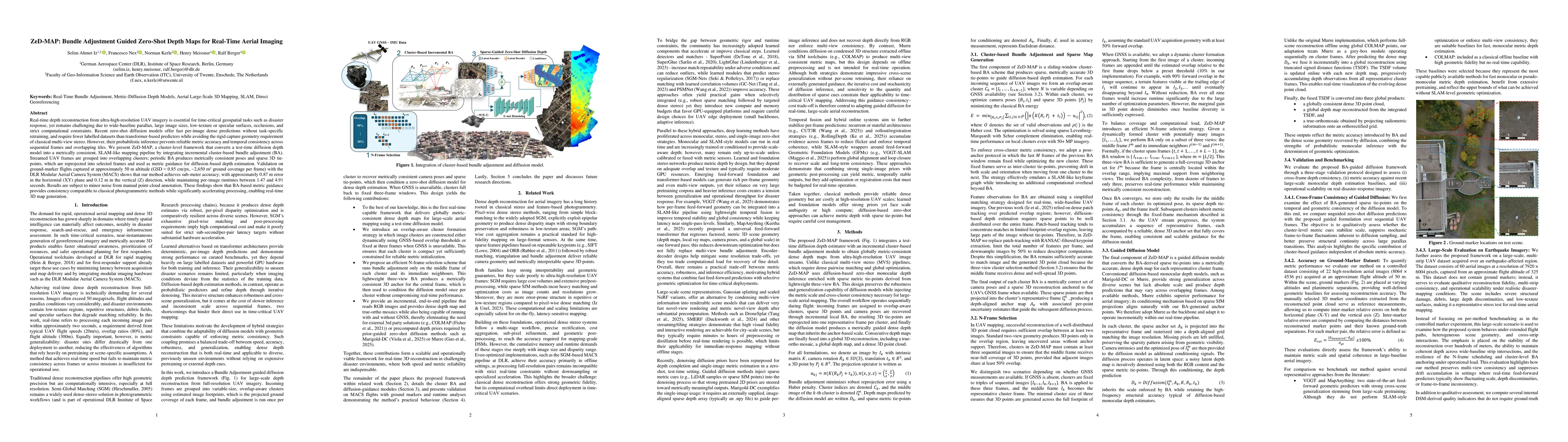
Real-time depth reconstruction from ultra-high-resolution UAV imagery is essential for time-critical geospatial tasks such as disaster response, yet remains challenging due to wide-baseline parallax, large image sizes, low-texture or specular surfaces, occlusions, and strict computational constraints. Recent zero-shot diffusion models offer fast per-image dense predictions without task-specific retraining, and require fewer labelled datasets than transformer-based predictors while avoiding the rigid capture geometry requirement of classical multi-view stereo. However, their probabilistic inference prevents reliable metric accuracy and temporal consistency across sequential frames and overlapping tiles. We present ZeD-MAP, a cluster-level framework that converts a test-time diffusion depth model into a metrically consistent, SLAM-like mapping pipeline by integrating incremental cluster-based bundle adjustment (BA). Streamed UAV frames are grouped into overlapping clusters; periodic BA produces metrically consistent poses and sparse 3D tie-points, which are reprojected into selected frames and used as metric guidance for diffusion-based depth estimation. Validation on ground-marker flights captured at approximately 50 m altitude (GSD is approximately 0.85 cm/px, corresponding to 2,650 square meters ground coverage per frame) with the DLR Modular Aerial Camera System (MACS) shows that our method achieves sub-meter accuracy, with approximately 0.87 m error in the horizontal (XY) plane and 0.12 m in the vertical (Z) direction, while maintaining per-image runtimes between 1.47 and 4.91 seconds. Results are subject to minor noise from manual point-cloud annotation. These findings show that BA-based metric guidance provides consistency comparable to classical photogrammetric methods while significantly accelerating processing, enabling real-time 3D map generation.

Key Findings, in focus

Seven facets of this paper, analysed and brought into focus by AI.

AI-generated · verify against source Generated Apr 07, 2026
In focus · one-line synthesis

By fusing sparse geometric optimization with zero‑shot diffusion, ZeD‑MAP delivers metrically consistent, temporally stable dense depth maps for UAV mapping without the need for extensive training data or offline SfM, enabling rapid, real‑time 3‑D reconstruction for time‑critical geospatial applications such as disaster response.

01
MethodologyHow they did it

ZeD-MAP processes UAV image streams by grouping overlapping frames into clusters, performing lightweight three‑view bundle adjustment to obtain metrically accurate camera poses and sparse 3‑D tie‑points, projecting these anchors into a representative frame, and feeding them as conditioning cues to a test‑time zero‑shot diffusion depth model (Murre) that produces dense depth maps; the resulting depth maps are fused incrementally into a TSDF volume to generate a global point cloud, depth map and orthomosaic.

02
ResultsWhat they found
  • Achieves sub‑meter metric accuracy on a ground‑marker dataset with 0.87 m XY error and 0.12 m Z error, matching classical photogrammetry while running in real time (1.47–4.91 s per image).
  • Demonstrates strong cross‑frame consistency, suppressing the stochastic scale drift typical of unguided diffusion and maintaining coherent depth across wide‑baseline UAV imagery.
  • Outperforms state‑of‑the‑art feed‑forward monocular depth predictors (VGGT, MapAnything) in both accuracy and runtime, and rivals offline COLMAP in local precision while being orders of magnitude faster.
03
SignificanceWhy it matters

By fusing sparse geometric optimization with zero‑shot diffusion, ZeD‑MAP delivers metrically consistent, temporally stable dense depth maps for UAV mapping without the need for extensive training data or offline SfM, enabling rapid, real‑time 3‑D reconstruction for time‑critical geospatial applications such as disaster response.

04
Technical ContributionsWhat's new technically

A novel cluster‑based bundle adjustment guided zero‑shot diffusion framework that injects metrically accurate sparse anchors into a diffusion depth estimator, enabling real‑time, globally consistent dense depth reconstruction from ultra‑high‑resolution UAV imagery.

05
NoveltyWhat sets it apart

First to combine test‑time diffusion depth estimation with incremental cluster‑based bundle adjustment for UAV mapping, achieving real‑time metric depth without offline SfM or per‑scene retraining, and demonstrating that sparse BA anchors can effectively steer diffusion models to produce globally consistent, accurate 3‑D reconstructions.

06
LimitationsWhat to be cautious about
  • Relies on diffusion inference, which remains computationally intensive and limits scalability to very high‑resolution images.
  • The approach depends on the quality of sparse tie‑points; in low‑texture or highly specular scenes, BA may produce insufficient anchors, reducing depth accuracy.
07
Future WorkWhere it goes next
  • Develop more efficient diffusion back‑ends or model pruning to further reduce inference latency and enable larger frame processing.
  • Integrate tighter SLAM‑style loop closure and multi‑view consistency checks to improve robustness under extreme viewpoints, rapid motion, and low‑texture environments.

Paper Details

Paper ID: 2604.04667
Categories:
cs.CV cs.LG cs.RO

How to Cite This Paper

Reference manager: RIS EndNote

Related Papers

4 found


Discussion 0

This website uses cookies to ensure you get the best experience. Learn more