ArxivLens
ArXiv cs.CV

3D Surface Reconstruction From Multi-Date Satellite Images

Christoph Bodensteiner, Michael Arens, Sebastian Bullinger

2102.02502 Published Apr 6, 2021
View PDF

Publication

Published: Apr 06, 2021
Categories: cs.CV

Metrics

Source: ArXiv

AI Quick Summary

This paper proposes an extension of Structure from Motion (SfM) to reconstruct detailed three-dimensional watertight meshes from multi-date satellite images, incorporating texture information. The method includes advanced calibration, skew correction, and depth map recovery techniques, and outperforms existing point cloud reconstruction algorithms in completeness and accuracy.

Quick Answers

What methodology did the authors use?

The paper proposes an extension of an SfM-based pipeline for 3D surface reconstruction from multi-date satellite images, enabling the generation of watertight meshes with texture information. More in Methodology →

What are the key results?

The proposed pipeline outperforms state-of-the-art point cloud reconstruction algorithms in terms of completeness and median error when evaluated on multi-date satellite images. — The method successfully leverages current state-of-the-art dense and surface reconstruction libraries for computing dense point clouds and non-textured meshes. More in Key Results →

Why is this work significant?

This research is significant as it enhances the reconstruction of accurate 3D models from satellite imagery, which is crucial for applications like urban planning, environmental monitoring, and disaster management. More in Significance →

What are the main limitations?

The method relies on high-quality metadata from satellite images, which might not always be available or accurate. — Computational requirements for high-resolution imagery might still pose challenges. More in Limitations →

Paper Preview

Abstract

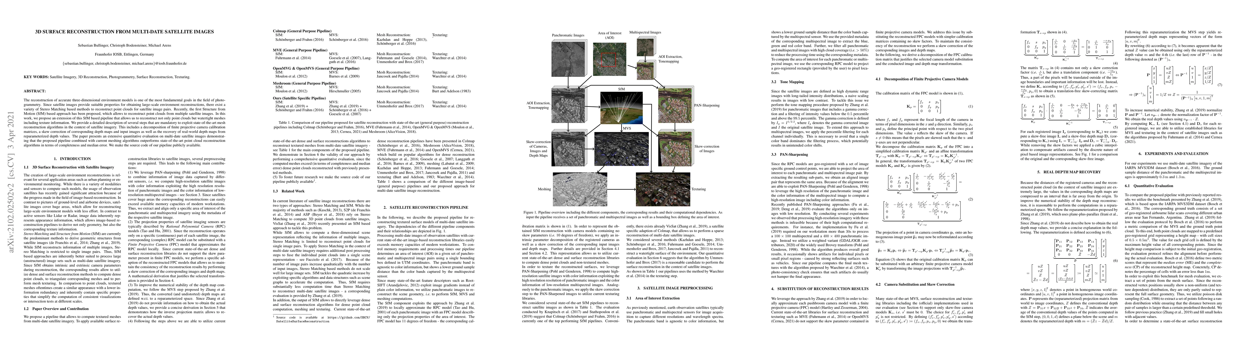
The reconstruction of accurate three-dimensional environment models is one of the most fundamental goals in the field of photogrammetry. Since satellite images provide suitable properties for obtaining large-scale environment reconstructions, there exist a variety of Stereo Matching based methods to reconstruct point clouds for satellite image pairs. Recently, the first Structure from Motion (SfM) based approach has been proposed, which allows to reconstruct point clouds from multiple satellite images. In this work, we propose an extension of this SfM based pipeline that allows us to reconstruct not only point clouds but watertight meshes including texture information. We provide a detailed description of several steps that are mandatory to exploit state-of-the-art mesh reconstruction algorithms in the context of satellite imagery. This includes a decomposition of finite projective camera calibration matrices, a skew correction of corresponding depth maps and input images as well as the recovery of real-world depth maps from reparameterized depth values. The paper presents an extensive quantitative evaluation on multi-date satellite images demonstrating that the proposed pipeline combined with current meshing algorithms outperforms state-of-the-art point cloud reconstruction algorithms in terms of completeness and median error. We make the source code of our pipeline publicly available.

Key Findings, in focus

Seven facets of this paper, analysed and brought into focus by AI.

AI-generated · verify against source Generated Sep 02, 2025
In focus · one-line synthesis

This research is significant as it enhances the reconstruction of accurate 3D models from satellite imagery, which is crucial for applications like urban planning, environmental monitoring, and disaster management.

01
MethodologyHow they did it

The paper proposes an extension of an SfM-based pipeline for 3D surface reconstruction from multi-date satellite images, enabling the generation of watertight meshes with texture information.

02
ResultsWhat they found
  • The proposed pipeline outperforms state-of-the-art point cloud reconstruction algorithms in terms of completeness and median error when evaluated on multi-date satellite images.
  • The method successfully leverages current state-of-the-art dense and surface reconstruction libraries for computing dense point clouds and non-textured meshes.
  • A skew correction of input images and depth maps is introduced to utilize current texturing libraries effectively.
03
SignificanceWhy it matters

This research is significant as it enhances the reconstruction of accurate 3D models from satellite imagery, which is crucial for applications like urban planning, environmental monitoring, and disaster management.

04
Technical ContributionsWhat's new technically

The paper presents a detailed description of several steps necessary to exploit state-of-the-art mesh reconstruction algorithms in the context of satellite imagery, including decomposition of finite projective camera calibration matrices, skew correction of images and depth maps, and recovery of real-world depth maps from reparameterized depth values.

05
NoveltyWhat sets it apart

The novelty of this work lies in extending the SfM-based approach for 3D surface reconstruction from multi-date satellite images to generate watertight meshes with texture information, outperforming existing point cloud reconstruction algorithms.

06
LimitationsWhat to be cautious about
  • The method relies on high-quality metadata from satellite images, which might not always be available or accurate.
  • Computational requirements for high-resolution imagery might still pose challenges.
07
Future WorkWhere it goes next
  • Exploration of more efficient algorithms to handle high-resolution satellite imagery.
  • Investigating the method's performance with various types of satellite sensors and imaging conditions.

Impact

41
References

Paper Details

Paper ID: 2102.02502
License: http://arxiv.org/licenses/nonexclusive-distrib/1.0/
Comments: Accepted at ISPRS Congress 2021
Categories:
cs.CV

How to Cite This Paper

Reference manager: RIS EndNote

Key Terms

satellite (0.265)
satellite (0.253)
point clouds (0.242)
reconstruct (0.231)
reconstruct (0.213)
pipeline (0.212)
clouds (0.204)
pipeline (0.199)

Citation Network

Current paper (gray), citations (green), references (blue)

Display is limited for performance on very large graphs.

Current Paper
Citations
References
Click to view


Discussion 0

This website uses cookies to ensure you get the best experience. Learn more