The research uses a Random Forest machine learning model to predict pedestrian destinations from density heatmaps generated from simulated pedestrian trajectories using the Vadere microscopic simulator.
Publication
Metrics
AI Quick Summary
This research investigates whether machine learning can predict pedestrian destinations from video data, using density heatmaps as inputs. A Random Forest model trained on a simulator dataset shows potential for inferring destination distributions, suggesting further exploration into camera placement and methodology.
Quick Answers
What is "Can we learn where people go?" about?
This research investigates whether machine learning can predict pedestrian destinations from video data, using density heatmaps as inputs. A Random Forest model trained on a simulator dataset shows potential for inferring destination distributions, suggesting further exploration into camera placement and methodology.
What methodology did the authors use?
The research uses a Random Forest machine learning model to predict pedestrian destinations from density heatmaps generated from simulated pedestrian trajectories using the Vadere microscopic simulator. More in Methodology →
What are the key results?
The methodology achieved an accuracy of up to 90% in predicting pedestrian destination distributions. — The study found that the position of the camera cutout has little effect on prediction quality, but the size significantly influences it, with a cutout covering at least 75 m² yielding optimal results. More in Key Results →
Why is this work significant?
This research demonstrates the potential of extracting pedestrian destination information from video data using machine learning, which could be valuable for urban planning, crowd management, and agent-based simulation improvement. More in Significance →
What are the main limitations?
The study is based on simulated data rather than real video footage. — The analysis did not consider the time dependency of consecutive snapshots fully. More in Limitations →
Abstract
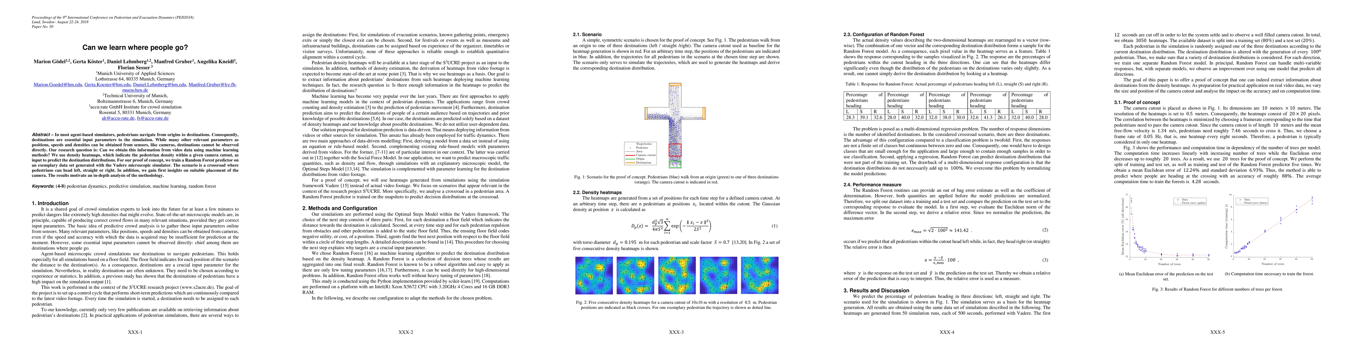
In most agent-based simulators, pedestrians navigate from origins to destinations. Consequently, destinations are essential input parameters to the simulation. While many other relevant parameters as positions, speeds and densities can be obtained from sensors, like cameras, destinations cannot be observed directly. Our research question is: Can we obtain this information from video data using machine learning methods? We use density heatmaps, which indicate the pedestrian density within a given camera cutout, as input to predict the destination distributions. For our proof of concept, we train a Random Forest predictor on an exemplary data set generated with the Vadere microscopic simulator. The scenario is a crossroad where pedestrians can head left, straight or right. In addition, we gain first insights on suitable placement of the camera. The results motivate an in-depth analysis of the methodology.
Key Findings, in focus
Seven facets of this paper, analysed and brought into focus by AI.
This research demonstrates the potential of extracting pedestrian destination information from video data using machine learning, which could be valuable for urban planning, crowd management, and agent-based simulation improvement.
- The methodology achieved an accuracy of up to 90% in predicting pedestrian destination distributions.
- The study found that the position of the camera cutout has little effect on prediction quality, but the size significantly influences it, with a cutout covering at least 75 m² yielding optimal results.
This research demonstrates the potential of extracting pedestrian destination information from video data using machine learning, which could be valuable for urban planning, crowd management, and agent-based simulation improvement.
The paper presents a novel approach to predict pedestrian destinations using density heatmaps and Random Forest, overcoming the limitation of directly observing destinations in video data.
This work differs from existing research by focusing on predicting pedestrian destinations from heatmaps using machine learning, rather than traditional classification or direct observation methods, and by analyzing the impact of camera placement on prediction accuracy.
- The study is based on simulated data rather than real video footage.
- The analysis did not consider the time dependency of consecutive snapshots fully.
- Investigate the robustness of the methodology across various scenarios.
- Study the impact of parameters like the number of pedestrians on prediction quality.
- Adapt the method to real video footage for practical applications.
Impact
Paper Details
Authors
PDF Preview
Key Terms
Citation Network
Current paper (gray), citations (green), references (blue)
Display is limited for performance on very large graphs.
Discussion 0