The study trained lightweight U‑Net and U‑Net++ convolutional decoders on 10 m AlphaEarth embeddings to regress Digital Surface Model heights, using a ResNet‑18 encoder and AdamW optimizer, and evaluated performance on an independent test set.
Inferring Height from Earth Embeddings: First insights using Google AlphaEarth
Publication
Metrics
Quick Answers
What methodology did the authors use?
The study trained lightweight U‑Net and U‑Net++ convolutional decoders on 10 m AlphaEarth embeddings to regress Digital Surface Model heights, using a ResNet‑18 encoder and AdamW optimizer, and evaluated performance on an independent test set. More in Methodology →
What are the key results?
Both U‑Net and U‑Net++ achieved R² = 0.97 on training, indicating embeddings encode strong height signals. — On the test set U‑Net++ outperformed U‑Net (R² = 0.84 vs. 0.78) with a lower RMSE (~16 m) and smaller bias, demonstrating better generalization. More in Key Results →
Why is this work significant?
The work shows that pre‑trained Earth embeddings can be leveraged for accurate regional height mapping with lightweight deep learning models, offering a computationally efficient alternative to expensive terrain‑specific training. More in Significance →
What are the main limitations?
Performance drops on unseen regions due to height distribution shifts between training and test areas. — Residual bias and RMSE (~16 m) indicate challenges in achieving high‑precision generalization across diverse terrains. More in Limitations →
Abstract
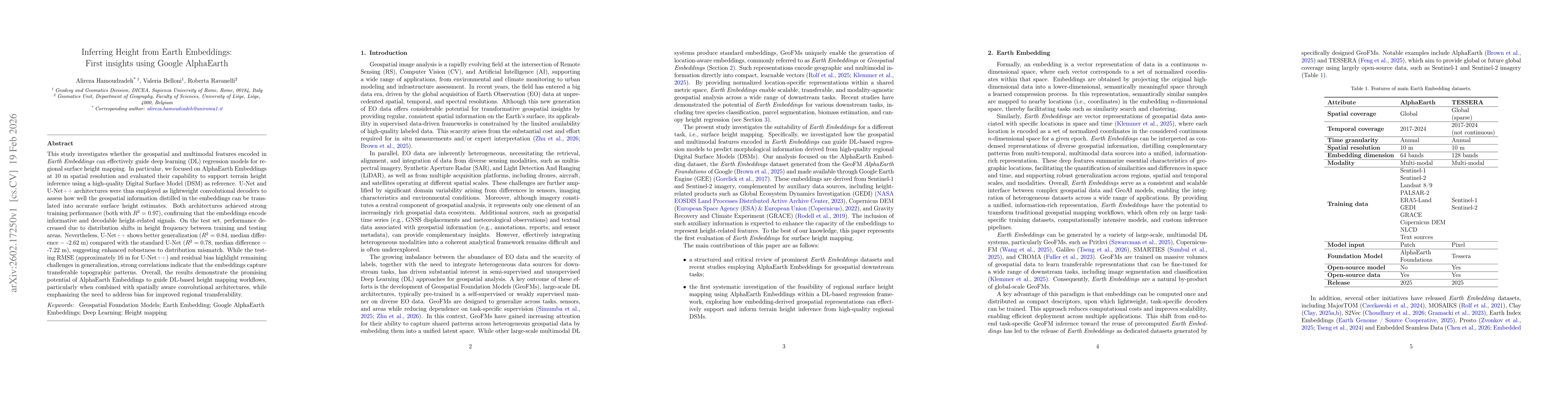
This study investigates whether the geospatial and multimodal features encoded in \textit{Earth Embeddings} can effectively guide deep learning (DL) regression models for regional surface height mapping. In particular, we focused on AlphaEarth Embeddings at 10 m spatial resolution and evaluated their capability to support terrain height inference using a high-quality Digital Surface Model (DSM) as reference. U-Net and U-Net++ architectures were thus employed as lightweight convolutional decoders to assess how well the geospatial information distilled in the embeddings can be translated into accurate surface height estimates. Both architectures achieved strong training performance (both with $R^2 = 0.97$), confirming that the embeddings encode informative and decodable height-related signals. On the test set, performance decreased due to distribution shifts in height frequency between training and testing areas. Nevertheless, U-Net++ shows better generalization ($R^2 = 0.84$, median difference = -2.62 m) compared with the standard U-Net ($R^2 = 0.78$, median difference = -7.22 m), suggesting enhanced robustness to distribution mismatch. While the testing RMSE (approximately 16 m for U-Net++) and residual bias highlight remaining challenges in generalization, strong correlations indicate that the embeddings capture transferable topographic patterns. Overall, the results demonstrate the promising potential of AlphaEarth Embeddings to guide DL-based height mapping workflows, particularly when combined with spatially aware convolutional architectures, while emphasizing the need to address bias for improved regional transferability.
Key Findings, in focus
Seven facets of this paper, analysed and brought into focus by AI.
The work shows that pre‑trained Earth embeddings can be leveraged for accurate regional height mapping with lightweight deep learning models, offering a computationally efficient alternative to expensive terrain‑specific training.
- Both U‑Net and U‑Net++ achieved R² = 0.97 on training, indicating embeddings encode strong height signals.
- On the test set U‑Net++ outperformed U‑Net (R² = 0.84 vs. 0.78) with a lower RMSE (~16 m) and smaller bias, demonstrating better generalization.
- Ridge regression performed poorly (R² = 0.38 on test), confirming the necessity of spatially aware decoders for height inference.
The work shows that pre‑trained Earth embeddings can be leveraged for accurate regional height mapping with lightweight deep learning models, offering a computationally efficient alternative to expensive terrain‑specific training.
Demonstrated that AlphaEarth embeddings can guide lightweight U‑Net‑based regressors to predict surface heights, providing a novel, efficient pipeline for regional height mapping.
First application of AlphaEarth embeddings for continuous height inference, combining them with nested‑skip U‑Net++ architecture to achieve superior generalization compared to linear baselines and prior embedding studies.
- Performance drops on unseen regions due to height distribution shifts between training and test areas.
- Residual bias and RMSE (~16 m) indicate challenges in achieving high‑precision generalization across diverse terrains.
- Expand the training dataset to cover broader spatial and morphological diversity, improving robustness to distribution shifts.
- Benchmark alternative embedding representations and evaluate the framework across geographically distinct regions to assess transferability.
Discussion 0