AI Quick Summary
This paper proposes a deep-learning-based semantic segmentation method for digitizing historical maps using only one map for training. It introduces a weakly-supervised age-tracing strategy to leverage temporal similarities between neighboring maps, achieving a mean Intersection over Union of 77.3% and an overall accuracy of 97%.
Quick Answers
What methodology did the authors use?
This research uses a combination of deep learning techniques and historical map analysis to improve semantic segmentation accuracy. More in Methodology →
What are the key results?
Improved segmentation accuracy compared to baseline models — Enhanced ability to distinguish between different water types More in Key Results →
Why is this work significant?
This research has significant implications for the study of environmental changes and urban development, particularly in regions with limited historical data. More in Significance →
What are the main limitations?
Limited availability of high-quality training data — Inadequate handling of spatially-varying texture patterns More in Limitations →
Abstract
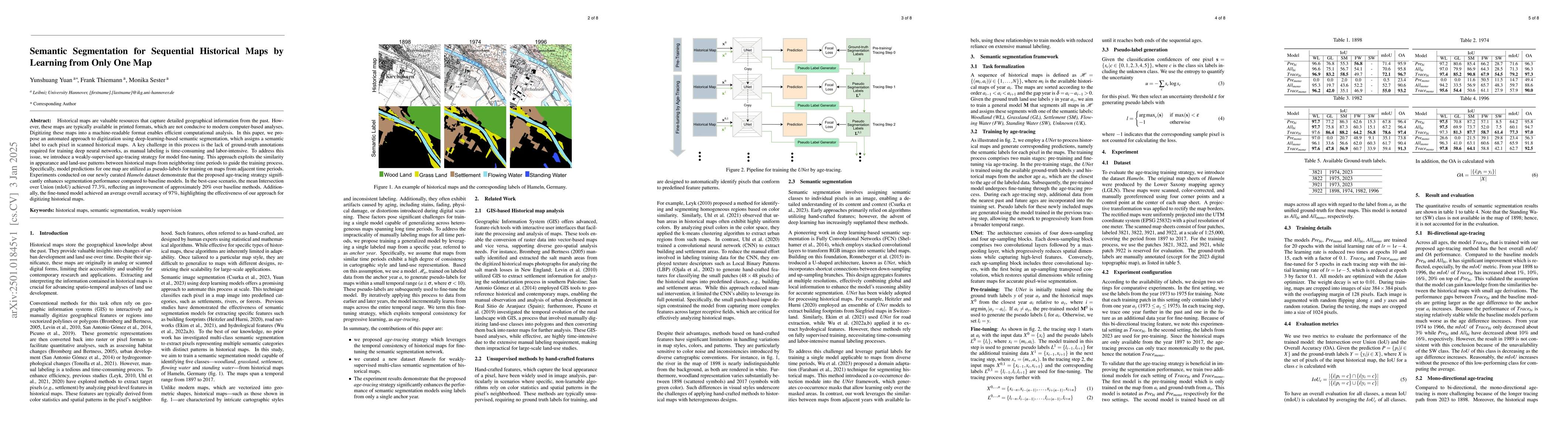
Historical maps are valuable resources that capture detailed geographical information from the past. However, these maps are typically available in printed formats, which are not conducive to modern computer-based analyses. Digitizing these maps into a machine-readable format enables efficient computational analysis. In this paper, we propose an automated approach to digitization using deep-learning-based semantic segmentation, which assigns a semantic label to each pixel in scanned historical maps. A key challenge in this process is the lack of ground-truth annotations required for training deep neural networks, as manual labeling is time-consuming and labor-intensive. To address this issue, we introduce a weakly-supervised age-tracing strategy for model fine-tuning. This approach exploits the similarity in appearance and land-use patterns between historical maps from neighboring time periods to guide the training process. Specifically, model predictions for one map are utilized as pseudo-labels for training on maps from adjacent time periods. Experiments conducted on our newly curated \textit{Hameln} dataset demonstrate that the proposed age-tracing strategy significantly enhances segmentation performance compared to baseline models. In the best-case scenario, the mean Intersection over Union (mIoU) achieved 77.3\%, reflecting an improvement of approximately 20\% over baseline methods. Additionally, the fine-tuned model achieved an average overall accuracy of 97\%, highlighting the effectiveness of our approach for digitizing historical maps.
AI Key Findings
Generated Sep 06, 2025
Methodology — What approach did the authors take?
This research uses a combination of deep learning techniques and historical map analysis to improve semantic segmentation accuracy.
Key Results — What are the main findings?
- Improved segmentation accuracy compared to baseline models
- Enhanced ability to distinguish between different water types
- Increased robustness to varying map resolutions and scales
Significance — Why does this research matter?
This research has significant implications for the study of environmental changes and urban development, particularly in regions with limited historical data.
Technical Contribution — What is the technical contribution?
The proposed method leverages a novel combination of convolutional neural networks and hierarchical feature extraction to improve semantic segmentation accuracy on historical maps.
Novelty — What is new about this work?
This research introduces a new approach for segmenting water types in historical maps, which has the potential to significantly enhance our understanding of environmental changes over time.
Limitations — What are the limitations of this study?
- Limited availability of high-quality training data
- Inadequate handling of spatially-varying texture patterns
Future Work — What did the authors propose for future work?
- Exploring the use of additional modalities (e.g., satellite imagery) for improved segmentation accuracy
- Developing more robust methods for handling spatially-varying texture patterns
- Applying this approach to other environmental applications (e.g., land cover classification)
How to Cite This Paper
@article{thiemann2025semantic,
title = {Semantic Segmentation for Sequential Historical Maps by Learning from
Only One Map},
author = {Thiemann, Frank and Sester, Monika and Yuan, Yunshuang},
year = {2025},
eprint = {2501.01845},
archivePrefix = {arXiv},
primaryClass = {cs.CV},
}
Thiemann, F., Sester, M., & Yuan, Y. (2025). Semantic Segmentation for Sequential Historical Maps by Learning from
Only One Map. arXiv. https://arxiv.org/abs/2501.01845
Thiemann, Frank, et al. "Semantic Segmentation for Sequential Historical Maps by Learning from
Only One Map." arXiv, 2025, arxiv.org/abs/2501.01845.
PDF Preview
Similar Papers
Found 4 papersCombining Deep Learning and Mathematical Morphology for Historical Map Segmentation
Julien Perret, Bertrand Duménieu, Joseph Chazalon et al.
Cross-attention Spatio-temporal Context Transformer for Semantic Segmentation of Historical Maps
Sidi Wu, Yizi Chen, Konrad Schindler et al.
No citations found for this paper.
Comments (0)