The study proposes a geometry‑aware UAV geo‑localization framework that reconstructs a local 3D scene from multi‑view UAV sequences using a Visual Geometry Grounded Transformer (VGGT), renders a virtual Bird’s‑Eye View (BEV) to align with satellite imagery, and employs a Satellite‑wise Attention Block to isolate candidate interactions while performing geometric and feature‑based validation for pose regression.
Unifying UAV Cross-View Geo-Localization via 3D Geometric Perception
Publication
Metrics
Quick Answers
What methodology did the authors use?
The study proposes a geometry‑aware UAV geo‑localization framework that reconstructs a local 3D scene from multi‑view UAV sequences using a Visual Geometry Grounded Transformer (VGGT), renders a virtual Bird’s‑Eye View (BEV) to align with satellite imagery, and employs a Satellite‑wise Attention Block to isolate candidate interactions while performing geometric and feature‑based validation for pose regression. More in Methodology →
What are the key results?
Achieves state‑of‑the‑art recall@1 and mAP on the recalibrated University‑Pose and SUES‑200 benchmarks, outperforming zero‑shot and supervised baselines; — Demonstrates meter‑level absolute pose accuracy with a 3‑DoF error below 3 m for 80% of queries; More in Key Results →
Why is this work significant?
By unifying coarse place recognition and fine pose estimation within a single 3D‑geometric pipeline, the work enables robust, zero‑shot geo‑localization for UAVs in GNSS‑denied environments, facilitating autonomous navigation and mapping in complex urban scenes. More in Significance →
What are the main limitations?
Relies on multi‑view image sequences, limiting applicability to single‑frame scenarios; — Explicit BEV rendering introduces quantization loss and increases computational overhead for large candidate sets. More in Limitations →
Abstract
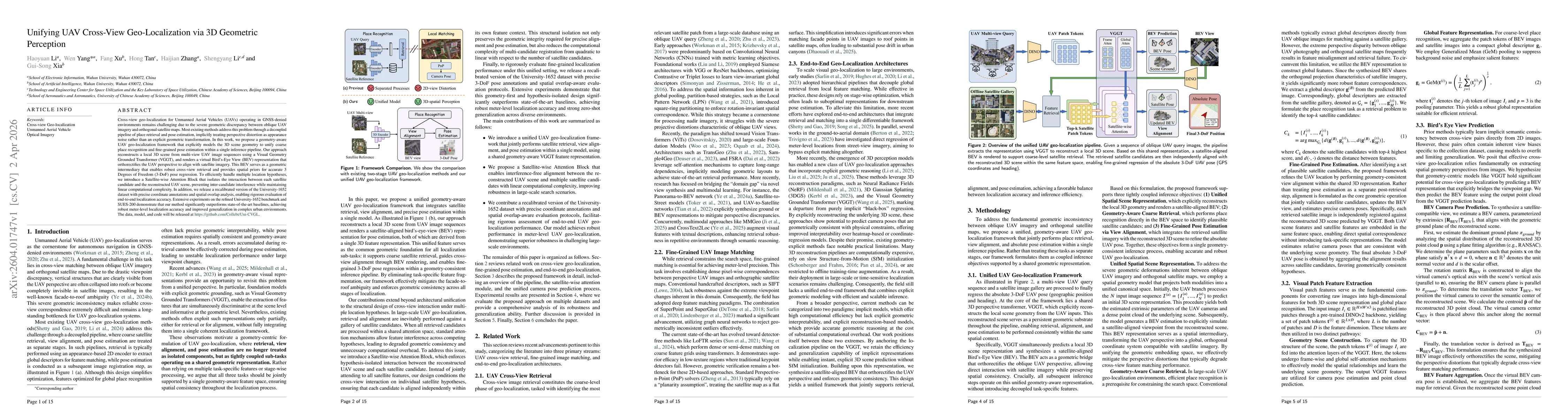
Cross-view geo-localization for Unmanned Aerial Vehicles (UAVs) operating in GNSS-denied environments remains challenging due to the severe geometric discrepancy between oblique UAV imagery and orthogonal satellite maps. Most existing methods address this problem through a decoupled pipeline of place retrieval and pose estimation, implicitly treating perspective distortion as appearance noise rather than an explicit geometric transformation. In this work, we propose a geometry-aware UAV geo-localization framework that explicitly models the 3D scene geometry to unify coarse place recognition and fine-grained pose estimation within a single inference pipeline. Our approach reconstructs a local 3D scene from multi-view UAV image sequences using a Visual Geometry Grounded Transformer (VGGT), and renders a virtual Bird's-Eye View (BEV) representation that orthorectifies the UAV perspective to align with satellite imagery. This BEV serves as a geometric intermediary that enables robust cross-view retrieval and provides spatial priors for accurate 3 Degrees of Freedom (3-DoF) pose regression. To efficiently handle multiple location hypotheses, we introduce a Satellite-wise Attention Block that isolates the interaction between each satellite candidate and the reconstructed UAV scene, preventing inter-candidate interference while maintaining linear computational complexity. In addition, we release a recalibrated version of the University-1652 dataset with precise coordinate annotations and spatial overlap analysis, enabling rigorous evaluation of end-to-end localization accuracy. Extensive experiments on the refined University-1652 benchmark and SUES-200 demonstrate that our method significantly outperforms state-of-the-art baselines, achieving robust meter-level localization accuracy and improved generalization in complex urban environments.
Key Findings, in focus
Seven facets of this paper, analysed and brought into focus by AI.
By unifying coarse place recognition and fine pose estimation within a single 3D‑geometric pipeline, the work enables robust, zero‑shot geo‑localization for UAVs in GNSS‑denied environments, facilitating autonomous navigation and mapping in complex urban scenes.
- Achieves state‑of‑the‑art recall@1 and mAP on the recalibrated University‑Pose and SUES‑200 benchmarks, outperforming zero‑shot and supervised baselines;
- Demonstrates meter‑level absolute pose accuracy with a 3‑DoF error below 3 m for 80% of queries;
- Shows that iterative BEV refinement and IoU‑based retrieval significantly boost recall and reduce relative pose error.
By unifying coarse place recognition and fine pose estimation within a single 3D‑geometric pipeline, the work enables robust, zero‑shot geo‑localization for UAVs in GNSS‑denied environments, facilitating autonomous navigation and mapping in complex urban scenes.
Introduction of a Satellite‑wise Attention Block that isolates candidate interactions, a geometry‑aware BEV intermediary for cross‑view alignment, and a combined geometric and feature validation strategy for robust pose estimation.
First framework to jointly perform coarse cross‑view retrieval and fine 3‑DoF pose regression via explicit 3D scene reconstruction, leveraging a Satellite‑wise attention mechanism and IoU‑based retrieval, achieving zero‑shot performance superior to existing methods.
- Relies on multi‑view image sequences, limiting applicability to single‑frame scenarios;
- Explicit BEV rendering introduces quantization loss and increases computational overhead for large candidate sets.
- Develop end‑to‑end differentiable training that jointly optimizes retrieval and pose regression;
- Explore single‑view unified perception by integrating monocular depth priors or neural feature fields to replace explicit BEV construction.
Discussion 0