The research presents a navigation solution for planetary rovers that augments camera and wheel-based robot odometry in low visibility and high slippage environments using UWB anchors distributed by the mobile system itself.
Publication
Metrics
AI Quick Summary
Researchers developed a novel UWB-based localization system for planetary rovers, using anchor nodes to create a reference coordinate system and supplement traditional SLAM techniques.
Quick Answers
What is "UWB Anchor Based Localization of a Planetary Rover" about?
Researchers developed a novel UWB-based localization system for planetary rovers, using anchor nodes to create a reference coordinate system and supplement traditional SLAM techniques.
What methodology did the authors use?
The research presents a navigation solution for planetary rovers that augments camera and wheel-based robot odometry in low visibility and high slippage environments using UWB anchors distributed by the mobile system itself. More in Methodology →
What are the key results?
UWB-based localization provides robust, accurate, and absolute positioning data, improving reliable localization and mapping in planetary exploration. — The system was successfully applied during the AMADEE-24 mission, demonstrating sufficient accuracy to complement SLAM methods. More in Key Results →
Why is this work significant?
This research is important as it motivates the use of UWB-based localization for planetary exploration, addressing challenges posed by unknown terrains, difficult lighting conditions, and the lack of global reference systems. More in Significance →
What are the main limitations?
The current implementation is limited to planar calculations, requiring significant altitude change for one anchor to obtain reliable 3D measurements. — Wheel odometry is restricted to planar poses, limiting the expected improvement in accuracy. More in Limitations →
Abstract
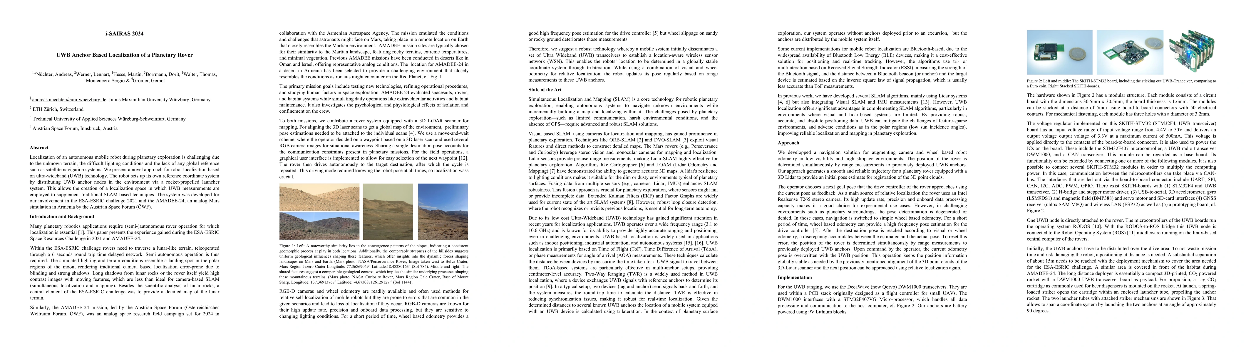
Localization of an autonomous mobile robot during planetary exploration is challenging due to the unknown terrain, the difficult lighting conditions and the lack of any global reference such as satellite navigation systems. We present a novel approach for robot localization based on ultra-wideband (UWB) technology. The robot sets up its own reference coordinate system by distributing UWB anchor nodes in the environment via a rocket-propelled launcher system. This allows the creation of a localization space in which UWB measurements are employed to supplement traditional SLAM-based techniques. The system was developed for our involvement in the ESA-ESRIC challenge 2021 and the AMADEE-24, an analog Mars simulation in Armenia by the Austrian Space Forum (\"OWF).
Key Findings, in focus
Seven facets of this paper, analysed and brought into focus by AI.
This research is important as it motivates the use of UWB-based localization for planetary exploration, addressing challenges posed by unknown terrains, difficult lighting conditions, and the lack of global reference systems.
- UWB-based localization provides robust, accurate, and absolute positioning data, improving reliable localization and mapping in planetary exploration.
- The system was successfully applied during the AMADEE-24 mission, demonstrating sufficient accuracy to complement SLAM methods.
- In-lab experiments showed that range measurements have an inaccuracy of about 40 to 70 centimeters, which subsequent processing algorithms must handle.
This research is important as it motivates the use of UWB-based localization for planetary exploration, addressing challenges posed by unknown terrains, difficult lighting conditions, and the lack of global reference systems.
The main technical contribution is a mobile robot system capable of distributing up to 5 UWB sensor nodes in an environment before exploration, providing a globally stable coordinate system for localization.
This work is novel as it proposes a UWB-based localization solution for planetary rovers that complements SLAM algorithms, particularly in environments where visual and lidar-based systems are limited.
- The current implementation is limited to planar calculations, requiring significant altitude change for one anchor to obtain reliable 3D measurements.
- Wheel odometry is restricted to planar poses, limiting the expected improvement in accuracy.
- Integration of results in an Extended Kalman Filter framework for robotic mapping.
- Exploration of using more than one receiver at the mobile robot for increased stability and orientation estimation.
Impact
Paper Details
Authors
PDF Preview
Citation Network
Current paper (gray), citations (green), references (blue)
Display is limited for performance on very large graphs.
Discussion 0